Substantial, fire season-mitigating late-October precipitation in NorCal? Plus: present drought breaks new records in CA
Offshore winds and high wildfire risk in recent days, but also some mountain snow
The weather has actually been rather active across much of California over the past week or so, but exactly what kind of active weather depends very much on where you were. Bands of heavy lake-effect snowfall blanketed parts of the Lake Tahoe basin with a few inches of powder while, simultaneously, very strong winds fueled massive dust storms in the San Joaquin Valley and SE deserts as well as new wildfires throughout the state. Fortunately, all but one of those new fires were contained rather quickly–the singular exception being the now ~17,000 acre Alisal Fire in Santa Barbara County. Additionally, the searing record heat of recent months (and years) has disappeared, at least for now: conditions have been near (or even slightly below) average across much of CA over the past couple of weeks. These relatively benign weather conditions, minus the occasional offshore winds, have allowed the state and region-wide fire situation to de-escalate substantially.
CA drought intensity breaks new records
Despite this relatively quiescent weather in recent days, the extreme California drought has continued to intensify in the meantime. In fact, by some key metrics, the present event is now the singularly most severe drought in California’s >100 year long direct observational record–surpassing even the maximum intensity of the last drought (2012-2016). This is a fairly alarming statistic, as we’re really only in the second year of the present drought yet it took three years for the last one to become so severe. A third consecutive very dry and/or very warm year would push California into historically unseen territory–and right now, there’s a non-negligible risk that this actually happens in 2022.
Some good news in the short term: fairly strong signs of widespread NorCal precip
But, for once, I do have some good news to share in the short term: it does appear increasingly likely that it’s going to rain substantially, at least in NorCal, before the end of October! In decades past, that would have been a fairly unremarkable occurrence–but following recent bone dry autumns, this event would mark a bit of a departure.
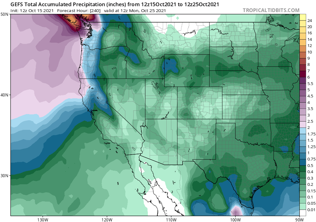
Right now, both the ECMWF and the GFS ensembles are pointing toward high odds of significant precipitation over the northern half of California beginning about 7 days from now, and perhaps continuing until the end of the month. Some precipitation is also possible over SoCal, though confidence is lower and amounts probably would be as well. Now, as many Weather West readers have remarked in recent days, the “operational/control runs” of both the ECMWF and GFS models have been bouncing all over the map–producing inconsistent solutions ranging from more dry conditions to enormous deluges. That’s not really unexpected behavior for single members of the large ensemble during the transition season (i.e., autumn)–and I’m encouraged by the relative consistency of the overall ensemble pointing toward at least a 5-7 day wet period ahead. I’m not sure I fully believe the actual predicted amounts–numerical models do tend to overestimate the amount of precipitation that occurs when the first storms of the season finally erode the very dry airmass over the state–but I still think that widespread light to moderate rain/snow is very plausible and perhaps even some heavy precip over far NorCal.
To be clear: this is not expected to be a major precipitation event in the context of the now record-breaking drought. But where it will help greatly, if it occurs as currently predicted, is with ending or at least greatly mitigating fire season across the northern 2/3 of the state. While SoCal often still sees significant fire activity for at least another month or so, NorCal’s fire season rarely lasted past mid-October historically. Recent trends have greatly expanded fire season through autumn and even into winter during dry years–so widespread autumn precipitation would be quite a blessing in that regard compared to most years in the past decade. My fingers…are tightly crossed.
Seasonal outlook is still dry, unfortunately, with strengthening La Niña conditions
Another month, another set of seasonal predictions from the multi model ensemble. And unfortunately, they continue to point toward substantially higher than average odds of a drier than average winter across most of California. In fact, if anything, the number of model members and magnitude of the respective dry signal has actually increased since this time last month–especially for the core of the rainy season from January-March. La Niña conditions have now officially re-developed, and models are also hinting at another substantial event at its eventual peak later this winter. The tropical West Pacific continues to be warmer than average, too–so basin-wide tropical ocean conditions remain in a favorable configuration for North Pacific winter ridging and drier than average conditions in California.
As discussed in the last post, seasonal predictions remain far from perfect–so there will always be a wide range of possible outcomes. And it may be that the next couple of months are not especially dry; models have been hinting for a while that either Nov or Dec could actually be fairly wet. But the prediction for increased odds for a dry winter overall would hold even if we do see some decent precipitation in the coming weeks. That’s obviously not great news, given the extremity of the ongoing drought in California and adjacent states.
And finally, I want leave folks with this closing thought (and a spectacular image from the ongoing volcanic eruption on La Palma in the Canary Islands):