Strong “Pineapple Express” atmospheric river to bring heavy rain, snowmelt, and a wide range of impacts to northern California
After extreme snowfalls in Feb, the antecedent conditions are primed
The past 3 weeks have featured extraordinary, even historic snowfalls across an unusually broad swath of California. Multiple rounds of sea level accumulations occurred along the North Coast, and repeated snowfalls down to 500-1000 feet in elevation have occurred throughout NorCal. The hills and mountains around the SF Bay Area retained a substantial snowpack for days; folks in the Mendocino and Lake County interiors have now been snowed in for a week or more; interstates have frequently closed in the Sierra and roofs have started to collapse under the extreme weight of accumulated snow. In the SoCal mountains, particularly the San Bernardinos, what was arguably the worst blizzard since the late 1980s in this part of the state has led to a widespread state of emergency, with folks trapped for extended periods without food or electricity (and resulting in a National Guard activation).
Suffice it to say: February 2023 was an extraordinary month for snow in California. And with a near-record snowpack in some places (though not others–notably including the northern Sierra) comes the reality that there’s a lot of water stored up in them thar hills. That water stored in the snowpack (known as snow water equivalent, or SWE) is going to melt eventually. And, based on the forecast, some of it (particularly at elevations below about 4,500 feet) might melt sooner rather than later. That always raises the specter of flooding at some later date–and, beyond the event that will likely unfold in the coming days, this very large snowpack will mostly remain intact until later in the spring (when it might pose the risk of more substantial and widespread snowmelt flooding later in the season).
Strong & warm “Pineapple Express”-type storm late Thu-Fri
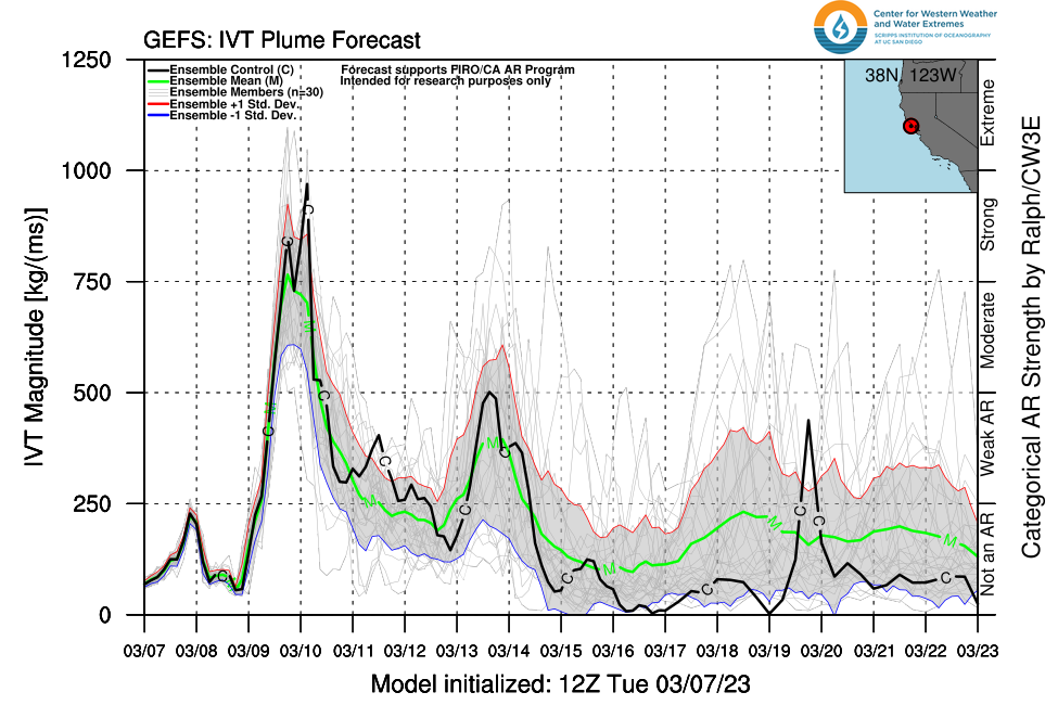
It’s been all over the news, and I’m here to tell you this much is true: a moderate to strong atmospheric river, with origins in the subtropics near Hawaii (hence, a “Pineapple Express” type event), is headed for California. ETA: late Thursday along the NorCal coast, and Friday further inland. This event will most likely be a “strong” (but not “extreme” or “exceptional”) event–comparable in magnitude (from an integrated water vapor transport perspective) with multiple events that occurred back in Dec and Jan in California.
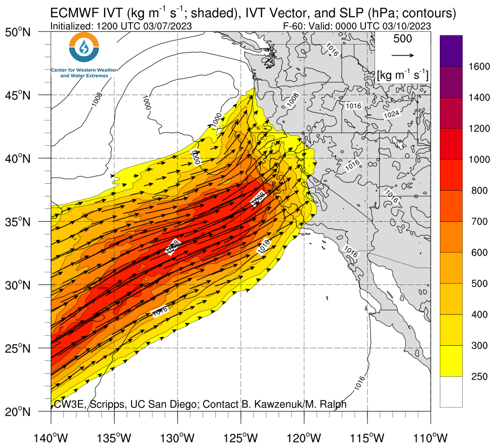
But in this instance, I think the impacts will likely be quite different than during the remarkable Dec-Jan storm sequence. First of all: this will be a warm and wet storm, with snow levels rising potentially above 6-7k feet (locally 8k+ at the storm’s warmest point). That’s going to result in a lot of snowmelt with the unusually substantial snowpack below ~4,000 feet or so (discussed more below). There will also be widespread moderate to heavy rain across much of NorCal and parts of central CA, leading to moderate rises on larger rivers and perhaps sharper rises on smaller rivers and streams. Some (minor to moderate) flooding is possible on various NorCal rivers this weekend, particularly smaller tributaries of the San Joaquin draining the central/southern Sierra western slope watersheds. Urban/small stream flooding is also likely to be pretty widespread elsewhere across NorCal.
Overall, the precipitation during the upcoming AR (and probably also during any that follow next week) will be more strongly orographic than the Dec-Jan ARs–there could be some pretty strong rain shadowing in lee side locations. This storm probably isn’t going to be quite as dynamic as the Dec/Jan storms, either–the surface low will be weaker and farther away, and the jet stream won’t be in quite as favorable a position. That means that maximum rainfall rates, as well as maximum wind gusts, will likely be lower during this event than previous events this season. So although there will be flooding, and probably some minor wind damage (power outages/limbs down and etc.), this might not be all that remarkable a storm in most of NorCal’s major urban areas (and it won’t be a major storm for SoCal at all).
However…
Impacts from snowmelt (and snow loading): flooding and mountain structural issues possible
…However, what makes this storm stand out is primarily its context with respect to very snowy and cold antecedent conditions. There is unusually much snow on the ground at places as low as 2,000 feet elevation in NorCal. In these places, the snowpack is still relatively “shallow” relative to that in the High Sierra (1-3 feet vs *dozens* of feet). In places where there’s 2-3 feet or less of snow on the ground right now, the inbound warm storm has a good potential to melt most or all of the snow. This is likely to be the case in the Coast Ranges, as well as the Sierra foothills–and that’s where I think the greatest risk of flooding will come from with this event (more so than at lower elevations and in urban areas). At higher elevations (i.e., 5-6 thousand feet or higher), the snowpack is so deep and so cold that even 18+ hours or rainfall will likely be mostly absorbed by the existing snow without generating much additional runoff.
That, however, is both a blessing (from a downstream flood risk perspective) and a curse (if you own property with a roof on it in the mountains). That’s because adding a bunch of liquid water to an already very deep snowpack can greatly increase its volumetric density and therefore the mass of snow plus water on structures–potentially causing already heavily snow-loaded roofs to collapse. This is potentially dangerous, and is a fairly widespread risk through the NorCal mountains with this event. Various local governments and emergency management groups have strongly suggested doing what you can in such locations to remove existing snow from roofs prior to Thursday evening to mitigate these risks (and watch out for your neighbors, too!). It is quite possible that structural damage from increasing snow loading (from rain atop snow) could end up causing more problems than the flooding with this Friday storm, so please take this threat seriously if you live in a place expected to see warm rain atop an existing heavy snowpack!
The highest river flood risk, right now, appears to be on tributaries to the San Joaquin both in the Valley itself and on the central/southern Sierra western slope. The risk does not currently appear to be severe, but that is always subject to change locally especially if the storm comes in stronger than currently anticipated or stalls over a particular watershed for longer than expected. So this would be a good week to pay close attention to forecasts if you live in such an area.
Finally: the risk of avalanches will probably high during this event in places that see rain-on-snow (for the same “snow loading” reasons mentioned above). This might even include some populated places outside of the backcountry.
Active pattern, including potential for additional warm ARs, continues next week
Right now, there are pretty strong indications that the active pattern will continue for the foreseeable future–though conditions will likely be wetter in NorCal vs. SoCal most of the time. The ensembles are suggesting the potential for a second warm atmospheric river event around the middle of next week, although right now indications are that while it would most likely be weaker than this weekend’s and produce relatively fewer flood impacts (though that is NOT a high confidence statement–and if next week’s AR potential increases, there could once again be a substantial risk of flooding, especially given compounding effects from residual runoff from this weekend’s storm.
The Pacific weather setup causing all this chaos is a pretty classic one from a Pineapple Express perspective: a strong ridge of high pressure in the Gulf of Alaska is being “undercut” by a strengthening subtropical jet stream–allowing subtropical moisture from near Hawaii to “phase” with moderately strong but colder low pressure systems diving southward on the east side of the GOA ridge. This puts California squarely in the path of warm ARs that form over the Northeastern Pacific.
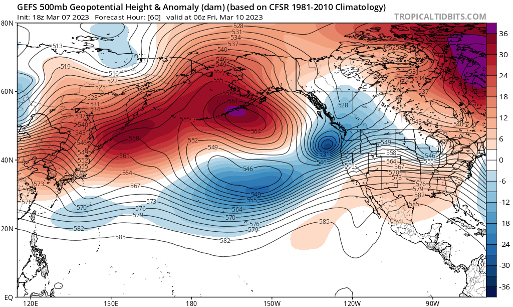
This overall pattern will probably continue at least into mid-March, although the GOA ridge will eventually weaken and the undercutting will no longer be sustained. That still leaves the storm door open overall, and in particular the risk of subtropical moisture incursions will be elevated. How much flood risk this ultimately produces beyond this weekend remains to be seen: if ARs are mainly weak to moderate and are spaced out widely enough in time, flood concerns would be pretty minor. If said ARs manage to synch up with a stronger surface cyclone, and/or several arrive in quick succsion, then it could very well be off to the races with flood potential given our very large Sierra snowpack. For now, it’s a waiting game; at the moment, I don’t see an obvious severe flood threat in the next 10 days–but the conditional risk will generally be present through April or May given the snow water storage already present.
A brief reflection on communicating risk to diverse audiences
It’s safe to say that the upcoming warm atmospheric river pattern in California has generated a lot of online buzz. Some of that is justified–it’s certainly notable when a warm rain event follows multiple extreme snowfall events, and there likely will be both flood and structure snow loading-related impacts (as discussed above). This will, very likely, cause genuine problems for real people.
But some of that chatter has, unfortunately, verged on misinformation. There are various social media accounts, and even some newspaper headlines, that have used language up to and including “extreme” or “catastrophic” to describe the flood risk from the Friday storm (or the broader sequence of storms that may (or may not) follow).
Let me be clear: there is absolutely no indication, at this time, of widespread severe flooding in California that would come anywhere close to being fairly characterized as “extreme” or “catastrophic.” As of this writing, the official river stage forecast from the California-Nevada River Forecast Center (a branch of NOAA) suggests that while quite a few rivers may exceed monitor stage this weekend, only a few will reach flood stage–and mostly minor (to perhaps moderate) flood stage at that. There will be additional flooding on smaller ungauged rivers and streams that that could well cause some locally serious problems. There is some potential for further atmospheric rivers next week to yield a second flood peak then, as well. But on the whole, and as far as the available evidence suggests at this juncture, it just doesn’t look like California’s going to see a historically severe event this time around.
Some additional perspective: the use of “catastrophic” language in operational weather prediction and emergency management circles is generally reserved for events that have a genuinely high potential to cause widespread loss of life and/or widespread severe property damage. The National Weather Service, for example, does not shy away from using the word “catastrophic” when it is actually justified–during declared flash flood or tornado emergencies, for example (among other hazards). But there has long been a principle in hazard and public safety communication that if people are “over-warned”–that is, if they repeatedly hear dire warnings that don’t ultimately come to fruition, they’ll be much less likely to respond constructively in the future when there there is a genuine emergency.
Someday, California will actually experience a catastrophic statewide flood event. It’s happened before, and it’ll happen again–but since climate change is raising the odds, and because the last “Big One” occurred in the mid 1800s, there’s a real risk that people won’t take those warnings seriously when they ultimately come. That’s one reason why it’s really important to keep things in perspective–and to be honest about both the range of possible outcomes but also to emphasize the most likely one (which is rarely the most extreme possibility).
Another YouTube live office hours session on Wed PM
I’ll be discussing the upcoming Pineapple Express event in more detail, including updates on potential impacts and thoughts regarding how much further flood risk might rise next week and beyond given the potential for additional warm storms and a very large Sierra snowpack.