Much needed & beneficial (and possible September record-breaking!) rain in NorCal this weekend! Then…warm and dry conditions resume.
A record-shattering September heat event…and a tropical storm.
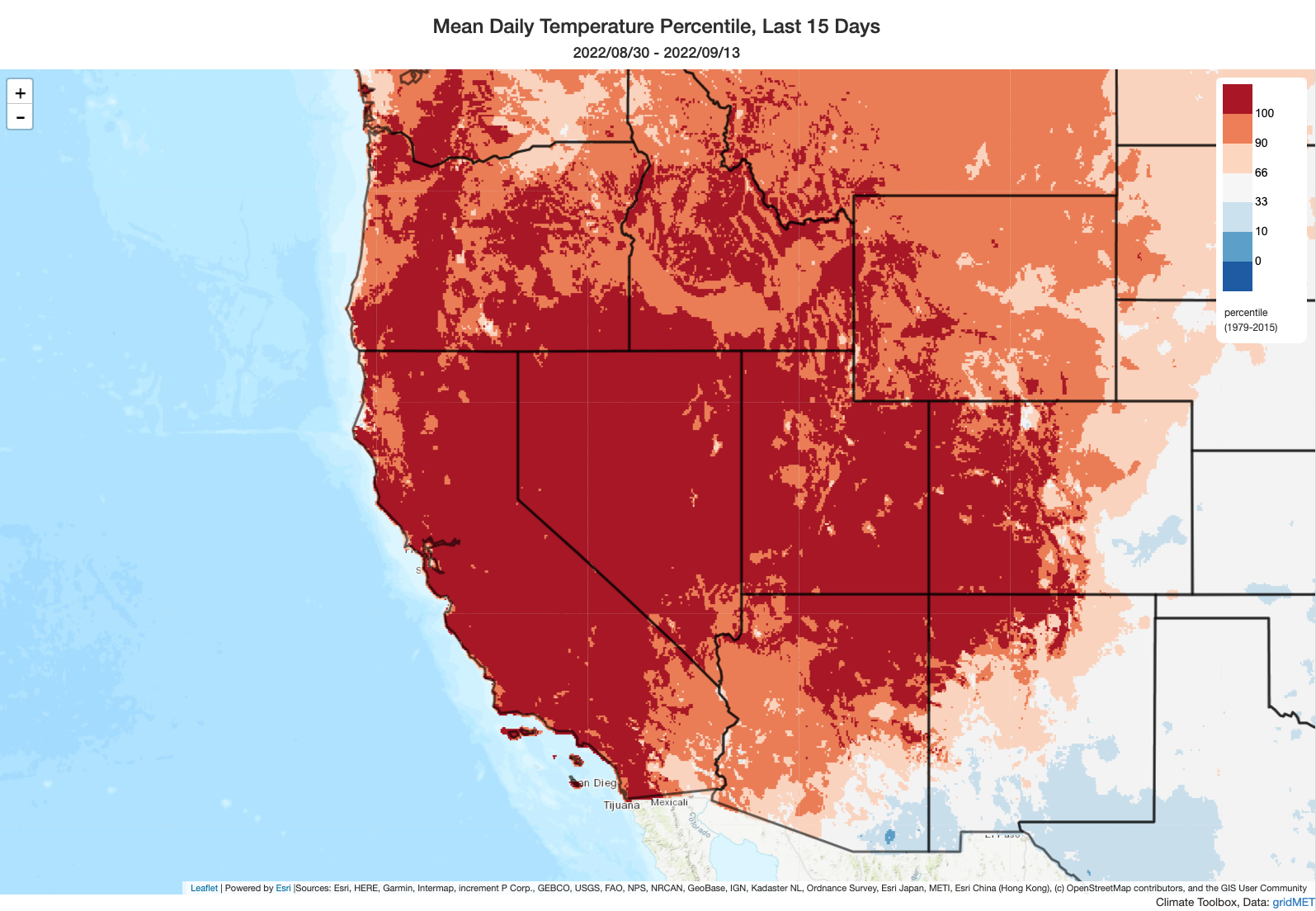
Well, it sure has been a September to remember in California, weather-wise. To start the month, the most severe September heatwave on record in the Western United States (and the worst heatwave in any calendar month, in some places) roasted California and adjacent states for 7-10 days. In Southern California, this was an unbearably humid heatwave; in Northern California, this was a much drier but even hotter event. Countless cities from northern Mexico to western Canada broke long-standing September monthly temperature records–some on multiple days–and some locations in northern California experienced their singularly hottest days on record…period. This includes the state capitol of Sacramento, as well as portions of the northern and eastern San Francisco Bay Area (Santa Rosa and Livermore) and the Mendocino County interior (Ukiah), where temperatures reached a truly extraordinary 115F to 118F. Many other locations set records for the greatest cumulative/consecutive number of 100 degree days (Sacramento set a similar record for consecutive 110F degree days). California’s power grid was pushed to the brink–logging an all-time record for statewide power consumption, but although there were some regional power outages rolling blackouts were narrowly avoided thanks to successful demand response actions (that is, people and commercial power users temporarily and voluntarily conserving for a few peak hours each day).
In the midst of this extreme heat, as well as ongoing severe drought, wildfire activity in both northern and southern California escalated dramatically. Multiple large (and even deadly) fires blew up in Southern California; in NorCal, the also deadly Mill Fire consumed an entire neighborhood in Weed, CA. Then, on the western slopes of the Sierra Nevada, the Mosquito Fire ignited near Foresthill–rapidly becoming the largest fire in California to date this season. This fire, which has also destroyed dozens of structures, experienced a period of exceptionally intense fire behavior at the peak of the heatwave–generating an extremely large pyrocumluonimbus cloud that likely generated multiple fire vortices and injected smoke into the stratosphere. The Mosquito Fire is, today, still marching steadily upslope amid record dry vegetation conditions.
As if all of that were not enough, Tropical Storm (and former hurricane) Kay made a historically close approach to Southern California at the same time huge fires were burning up north. This system brought strong winds to San Diego County and widespread rainfall elsewhere, although the heaviest rains were concentrated in the southeastern deserts of California where some very dry parts of the state saw 1-2 years’ worth of precipitation in a 1-2 day period (2-4 inches of rain). Significant flash flooding and debris flows also resulted on a more localized basis in some steep canyons and near recently burned areas. Quite the contrast between northern and southern California during this event, that’s for sure!
Widespread soaking rainfall headed for Northern California later this weekend! You can thank former West Pacific Typhoon Merbok for this one.
Well, the recent California whiplash is set to continue in the coming days. And for once, this particular whiplash iteration brings mainly good news to Northern California–it’s going to rain, rather substantially in some spots, right at the peak of fire season. Let me dig into the details.
The origins of this interesting and very unusual early season rain event are actually all the way over in the tropical Western Pacific Ocean, thousands of miles from California. That’s where soon-to-be former Typhoon Merbok originated, and its remnant low pressure center will undergo dramatic transition to a powerful extratropical cyclone over the Aleutian Islands that may result in a severe and damaging coastal storm (with massive waves, storm surge, and hurricane-force sustained winds) in some parts of coastal Alaska. In this instance, that particular storm is not headed for California. However, its presence in western Alaska will induce a sudden amplification of the downstream flow pattern. A strong ridge will rapidly develop in response over the eastern Gulf of Alaska in precisely such a position that favors the subsequent downstream development of an unusually deep early season trough and associated low pressure system just to the west of California this weekend.
Improbably for September, this system will be associated with relatively cold air aloft and a pretty favorable synoptic/jet stream setup to deliver healthy precipitation to a broad swath of northern California Sunday into Monday. A 24-48 hour long period of precipitation can be expected in many areas, beginning with a fairly robust cool/cold frontal rainband and subsequently by some convective showers (and, very possibly, isolated thunderstorms too). Light September showers are not that unusual in NorCal, but rainfall of the magnitude currently predicted for this upcoming event would be very rare to unprecedented for this early in the season. In fact, it is possible that some locations in/near the San Francisco Bay Area (including San Francisco itself) could break all-time daily or even monthly precipitation records if as little 1 inch of rain falls in a 24 hr period–which appears possible! That would probably ensure 2022 clinches the title as the weirdest Water Year on record in California, with record-breaking October rainfall in 2021, record-breaking mid-winter/peak season dryness yet a damp early spring/summer, then record wet conditions again the following September.
A fire season-alleviating, but not fire season-ending, precipitation event. And what about the Mosquito Fire?
The rain expected this weekend is, quite frankly, excellent news from a short-term wildfire risk perspective in the northern half of California. Sep-Oct are increasingly seen as the peak of fire season in NorCal, so this event could not be better timed from that perspective. And it is likely to help substantially tamp down the ongoing Mosquito Fire on the Sierra west slope–probably extinguishing pockets of the fire entirely, although some areas in heavy and drought-killed fuels will likely continue burning or smoldering until after the rain event, and could pop back to life then. This is one of the occasions where a storm is far more likely to produce net societal and ecological benefits than harms, and it’ll allow folks in NorCal to take a serious heatwave and wildfire breather.
There is one fire-related concern in the meantime, though: as the storm approaches, and prior to any rainfall, strong south to west winds (25-35 mph, with higher gusts) will occur along the western Sierra Nevada slopes. This may cause the Mosquito Fire to make a big run upslope in the general direction of the northern Tahoe Basin–although I *think* it’s still too far away for the fire to reach the basin itself prior to the arrival of rains (fortunately). So, be prepared for a big blowup on the eastern flank of the Mosquito Fire Fri into Sat before activity greatly diminishes amid damp conditions late Sun into Mon.
It is also important to emphasize, contrary to a headline today from at least one major national news outlet, that this upcoming rainfall (as beneficial as it will be!) will not singularly end fire season in California. Far from it, given the fact that vegetation conditions are presently at record dry levels for the date in NorCal and at/near record dry levels for *any* calendar date in the wake of the record-shattering heat event earlier this month. The upcoming rainfall will certainly reduce fire risk nearly everywhere in NorCal and push fuel moistures well above record dry levels in the short term. But it would take multiple consecutive events like the upcoming one to truly end fire season. And that’s not likely to be in the cards–in fact, much warmer and drier/windier conditions are expected to immediately follow the upcoming rain event. So unless there is another significant rain event in the first half of October, I’d expect wildfire risk to gradually ratchet back upward by early-mid October (but things are looking quite good for the second half of September, regardless of what happens after that, and that’ll take a big bite out of the peak of fire season).
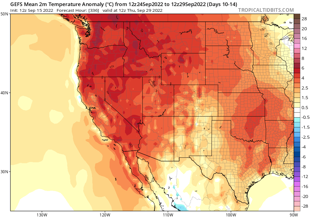
Following the Merbok-induced excitement, California (and the broader West Coast) will see a return to regular programming. Multi-model ensembles strongly suggest a return to anomalous ridging and well above average temperatures to finish out the month, along with the potential for some modest offshore wind events. (This is, decidedly, a less nerve-wracking prediction than it would have been were soaking rainfall not in the forecast prior to that sequence.) That might actually end up being a pretty pleasant late-season heatwave, given the likely lack of wildfire smoke or substantial wildfire risk (at least in NorCal). Stay tuned.
A brief note about the winter to come
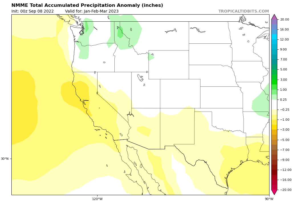
Alas, despite the good news in the short term, I have no such good news to share regarding the winter outlook. There is quite strong ensemble agreement, at the moment, regarding elevated odds of a drier than usual winter across most of California and the southern Colorado Basin–two places that could really, really use a wet winter about now. The usual caveats apply: this is a probabilistic, vs deterministic, prediction; seasonal outlooks are only modestly skillful; and there are some factors (including random good/bad luck) that the seasonal models can’t capture. That said, we’re going to be in the third consecutive year of a “Triple Dip” La Niña event, and the reliability of ENSO teleconnections does seem to increase in successive years (so predictions for persistent North Pacific ridging are not surprising). This is especially true in light of continued very warm ocean conditions in the far tropical western Pacific, which also favor northeastern Pacific ridges in winter (on top of the La Niña influence). So, I’ll continue to follow this in the coming weeks and months–but right now I’m not seeing much indication of medium term drought relief (if anything, the opposite).