Swing and a miss: anticipated October rain evaporates, and more adverse fire weather on horizon
September: record warm in California
It was a September to remember across California, and not in a good way. Following an extraordinary lightning fire siege and record heat in August, September brought…an even more destructive second surge in wildfire activity, and yet more record heat. In fact, following the hottest August on record in California, September was also the warmest on record in California. A few spots even reached new all-time record high temperatures (for any month) during the Labor Day heatwave.
And then, of course, there was the relentless smoke. Terrible air quality and frequent daylight-dimming “smokestorm” conditions actually resulted in a slightly cooler month than would otherwise have been the case (and, again, September was still *record* warm). The near daily occurrence of unhealthy or even dangerous particulate air pollution in many regions has resulted in a sustained public health crisis across California and other Western states–compounding that of the ongoing COVID19 pandemic. While there are still numerous fires contributing to the pervasive smoke cover, one in particular–the August Complex in northwestern California–is particularly of note. As of this writing, this now-contiguous fire complex has burned over a million acres of land–the first such true “megafire” (some say “gigafire”) in modern California history.
I’m very sorry to report that it’s not going to rain this weekend; offshore winds possible next week
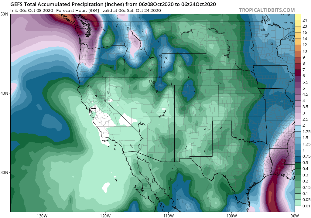
There was a lot of excitement on social media (and the Weather West comments section) regarding the potential for a significant and wildfire-mitigating rain event this weekend. The models struggled for many days with the evolution of this extremely complex pattern–sometimes generating copious rain and thunderstorms, other times suggesting the possibility for a bone-dry outcome if everything didn’t come together right. The model *ensembles*, meanwhile, suggested far more muted precipitation changes–including about a 1 in 3 chance of little to no precipitation.
Very unfortunately, that 1 in 3 possibility has come to fruition: little to no rain is now expected anywhere in California during this weekend’s transient “pattern shift.” The original tropically-infused system will likely fall apart as it veers southward off the CA coast, and the more traditional Pacific Northwest frontal system is now expected to largely “wash out” to the north of California. The net effect? Lots of clouds today through Sunday with some onshore flow and possible coastal drizzle from an enhanced marine layer, plus the lingering possibility of a few sprinkles/light showers (with little/no accumulation) mainly across the North Coast and northern Sierra.
All of this is still net positive news from a wildfire perspective: fire risk and behavior will be moderated near the coast for at least a few days, and the wind shift is still expected to clear out smoke over much of CA. But it will do little or nothing to slow fire season in the long run in most places. And the departing system on Sunday is now expected to be followed by some weak to moderate offshore winds–especially in northern California–as cold air moves into the Great Basin.
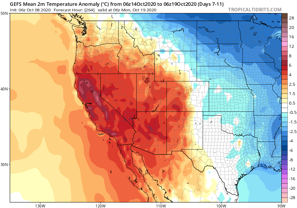
Looking forward a bit, the news does not get much better for foreseeable future. There is strong multi-model ensemble agreement that a pretty strong ridge will once again rebuild along the West Coast–leading to another extended period of above-average temperatures possibly punctuated by occasional offshore wind events over the next 2 weeks. In fact, the CFS foresees this continued spell of overall anomalous warmth and below average precipitation continuing for 2-3 more weeks.
Winter outlook: unfortunately, it’s looking dry with strong La Niña conditions
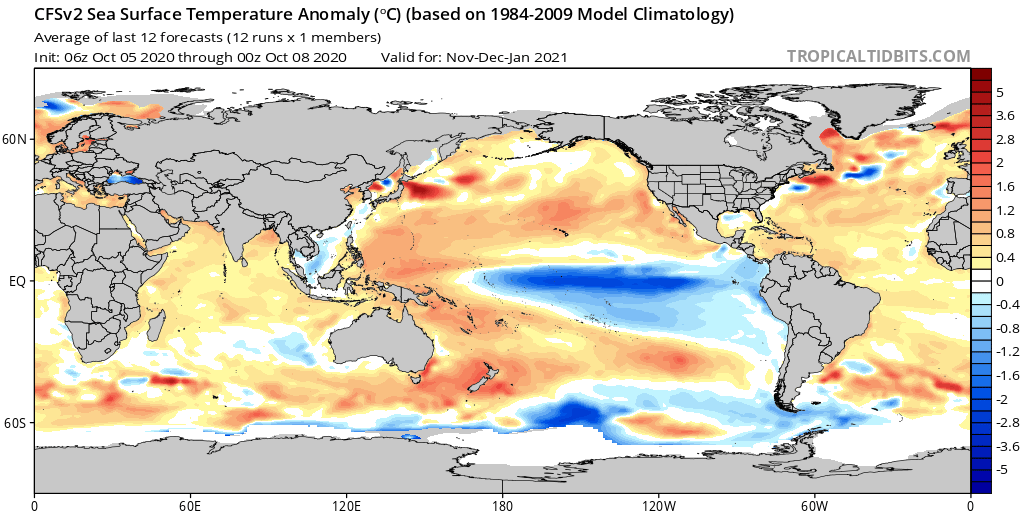
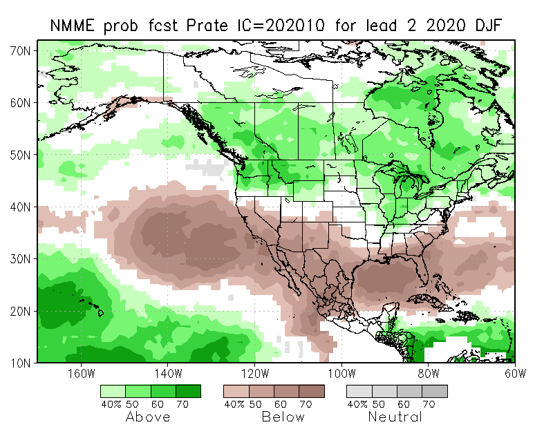
I’ve been holding off having this discussion for weeks, since I was hoping I could temper the seasonal outlook with some good short term news. Well, I guess that was not to be. There is now growing confidence that moderate to strong La Niña event will continue to strengthen and persist for much of the coming winter–substantially increasing the odds of a dry winter across most of California. Seasonal predictions are increasingly looking like a classic “strong La Niña” composite, with anomalous East Pacific mid-latitude ridging, increased precipitation over the Pacific Northwest, and decreased precipitation over California (especially the southern 2/3 of the state, but possibly also including far NorCal). This, combined with the likely emergence of a very “warm blob” of ocean water in the western tropical Pacific, are likely why the seasonal predictive models are in near unanimous agreement that the odds are tilted toward a dry winter in California this year.
It’s worth noting three things here. First, while seasonal precipitation outlooks in California do not (on average) have a very good track record, they actually perform reasonably well *during strong ENSO years.* That’s likely because a strong El Niño or La Niña event gives a big enough “kick to the system” to yield some meaningful predictive skill months in advance. Second, increased *odds* of a dry winter do not mean that the winter is definitely going to be dry–it just means the chance is substantially higher than it would be otherwise.
Third, even if we *do* see a dry winter in California, that does not mean we won’t see any major storms and rain events. (Indeed: we have some research currently in progress that suggests that certain kinds of “one off” extreme storms in California may be *more* common during La Niña years!). This is especially important to keep in mind given that hundreds of thousands of folks in California are currently living downhill from recent large and/or high-intensity wildfire burn scars with major debris flow/flash flood risk. It would only take one big event to cause major problems in that regard. I guess the only good news at the moment is that there’s nothing on the immediate horizon of concern from a post-fire debris flow perspective.
Research highlight: new work on California hydroclimate extremes in warming climate
I wanted to highlight some new work on California hydroclimate in a warming climate led by Geeta Persad along with co-authors Pablo Ortiz, Claire Kouba, and me. In this work, we find that there is pretty high agreement across different climate models regarding changes in California precipitation extremes and seasonality–even in cases when those same models disagree regarding whether the state will see more or less precipitation overall! Using a new set of data, we corroborate earlier findings regarding trends toward a shorter but more more intense rainy season, increasing precipitation whiplash, and dramatically reduced mountain snowpack as temperatures rise (among other important shifts). Collectively, we find that there’s actually higher confidence regarding changes in California hydroclimate extremes and seasonality than has often been assumed in a planning and climate adaptation context. If you’re interested in the details, you can check out the Twitter thread below or access the freely-available paper directly.