After a very active Dec-Jan, a (much) calmer start to Feb
A (brief) debrief on the Dec-Jan storm sequence in CA
Well, that was quite an intense period of California weather from late December into mid-January! A roughly three week-long sequence of moderate to strong storms buffeted most of California–ultimately bringing historically significant precipitation and widespread water and wind-related impacts. One of the first storms in the sequence, on New Year’s Eve, brought record-breaking daily precipitation along an axis just south of I-80 from near San Francisco into the Central Sierra foothills. Subsequent storms were aimed along a broader swath of the California coast. Widespread wind damage, with major tree damage and power outages, were especially pronounced in the southern Sacramento Valley and along portions of the Coast Ranges from about Santa Cruz County northward. Flood impacts were more broadly felt; although mainstem river flooding was mostly minor, more damaging localized flash flooding was reported in a large number of urban areas and along smaller creeks, streams, and rivers (particularly in El Dorado, Santa Cruz, and Santa Barbara/Ventura counties).
These storms were notable for their remarkably convective nature: an unusually high level of atmospheric instability yielded almost continuous lightning during some of these events. This is highly unusual for California winter storms, although has been known to occur during previous stormy episodes characterized by a strong low-latitude zonal jet and cold air aloft. There were even some strong to severe thunderstorms at times–which produced damaging winds and at least one confirmed tornado. In fact, some of the most intense localized wind damage in the above mentioned areas likely originated from these strong convective bands that swept across much of the state.
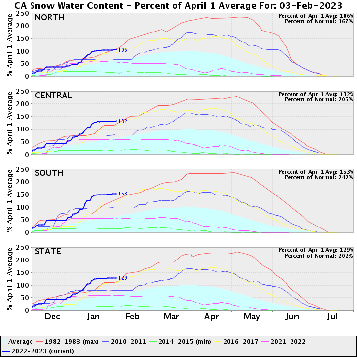
These storms also brought massive snowfalls to the Sierra Nevada. Statewide snowpack is now around 200% of average for the calendar date, and slightly over 100% of average relative to the historical average April 1 maximum! That equates to a lot of stored water up in the mountains, and a very substantial increment of drought relief (even as it raises the possibility of significant snowmelt flood risk in the San Joaquin watershed later this season–stay tuned on that front).
As dramatic, disruptive, and even deadly (the cumulative statewide death toll is around 20) as these storms were–I do want to contextualize them a bit relative to the historical record and our recent ARkStorm 2.0 scenarios. There have been multiple other statewide cumulative 3-week precipitation events comparable to the Dec 2022-Jan 2023 sequence since the 1950s, including: Dec 1995, Jan 1995, and Jan 1969. The recent sequence did somewhat exceed the statewide values seen during Jan 1998 and Jan 2017. But relative to both ARkStorm 2.0 scenarios, the recent sequence fell short: the 2022-2023 event was equivalent to ~75-80% of our smaller ARkHist scenario, and only about 50% of our far more severe ARkFuture scenario.
Future studies will quantify this more precisely, but a reasonable ballpark estimate is that climate warming to date likely increased the amount of precipitation during the 2022-23 event anywhere from ~5% to 15% (yielding an increase in likelihood for an event of similar magnitude of perhaps 50% relative to the climate of the 20th century–consistent with our estimate that climate change has already doubled increased the risk of an ARkHist-level storm sequence).
Pattern to come: modestly active, though probably drier than average for Feb
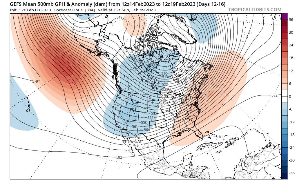
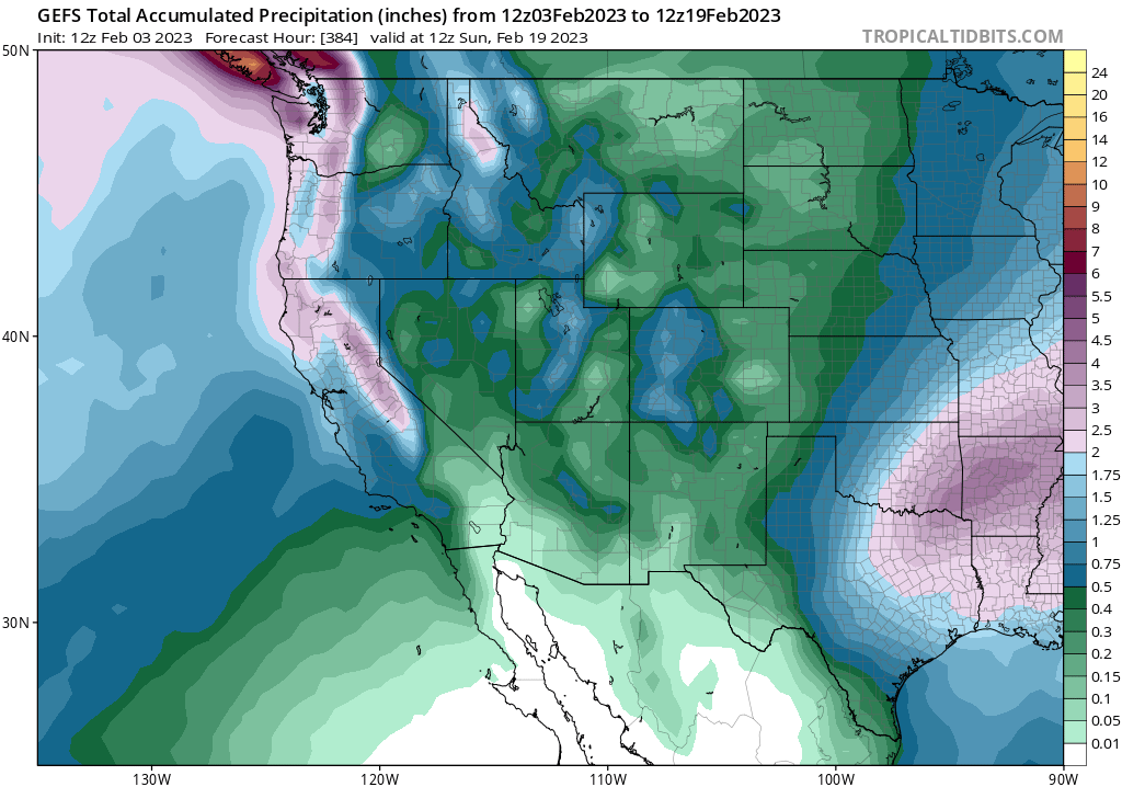
After a 2-ish week dry spell (or mostly dry spell) across much of California, a modestly more active pattern is currently developing and will likely continue for the next couple of weeks. A strong and persistent ridge in the Gulf of Alaska will further strengthen during this period, but is expected to be just far enough upstream (to the west) of California to allow the Golden State to remain under the primary influence of a weak trough. This setup will favor the occasional incursion of mainly weak but cold storms across California, especially the northern half of the state. These will likely be decent snow producers, though will probably only produce light (to locally moderate) precipitation accumulations overall.
For this reason: the upcoming period will probably still be drier than average for this time of year, despite the occurrence of occasional precipitation. That’s because early to mid February is one of the climatologically wettest periods of the year across much of California–so the likely absence of any heavy precipitation events would actually mean that somewhat less than the average amount of precipitation will accumulate over this period. Still, given the very wet antecedent conditions in December and the first part of January, this represents a pretty favorable weather pattern: there will be near zero additional flood risk, while Sierra snowpack will receive yet another top-up.
Temperatures during this period will likely remain close to average, though perhaps trending slightly below average toward mid-Feb again as the trough axis shifts slightly westward. In short: the next couple of weeks will likely feature a pretty benign weather period, with neither very cold nor very warm temperatures and a notable lack of major storm systems (despite occasional weaker ones).
For some fun weather and climate discussion: check this out!
If you’re into podcasts, weather, Adam Conover, or any combination of the above–check out my recent conversation with Adam on his Factually! podcast. We recorded this one right in the middle of the Dec-Jan storm onslaught, but there’s plenty of discussion that I suspect will be of broad interest to the blog readership!
After a very active Dec-Jan, a (much) calmer start to Feb Read More »