Major heatwave to bring increased wildfire risk, and (finally!) a substantive monsoonal surge to California & Southwest
August has been considerably warmer than July in most spots–and will likely end up above average statewide
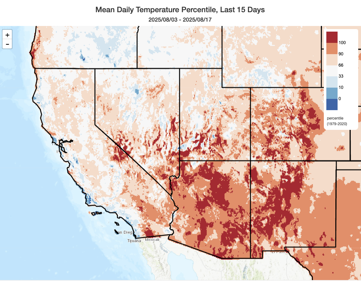
The latter portion of June and most of July was a notably cool summer period for much of California–contrary to both short- and medium-term expectations. But the first half of August has, once again, seen a return to warmer than even the recent (climate-warmed) average for August, at least across inland areas. The central and northern California immediate coastal zone did remain cooler than average during most of this period, though that has begun to change in recent days.
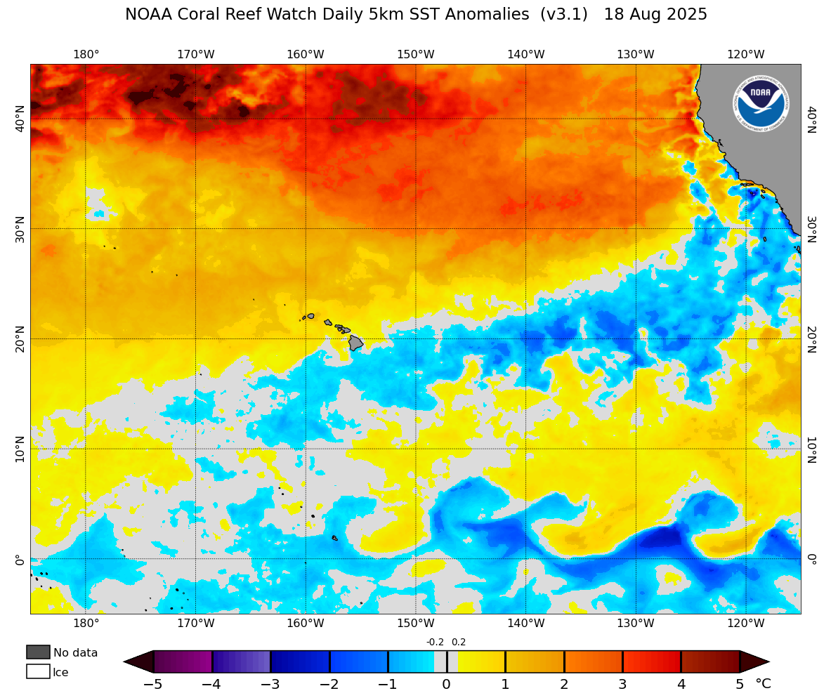
In fact: the enormous and exceptional (and in some cases record-breaking) “warm blob” of surface ocean water that has been present all summer across most of the North Pacific has finally made it all the way to the central and northern California coast in the past few days. For the first time this year, warmer than average ocean temperatures are present not just along the immediate coastline of SoCal but also along the upwelling zone west of NorCal–including near the SF Bay Area and North Coast region. This means the exceptionally persistent upwelling that has been present nearly all summer so far is essentially gone, at least for the moment, and the upcoming heatwave will reinforce this recent near-shore ocean warming trend. For this reason, the striking coolness and deep marine layer along the coast that have persisted longer than expected this season do appear to have dramatically faded in recent days. And with anomalous heat expected to persist across nearly all of California for the rest of August, it’s likely that the month overall–and, thus, the canonical summer period of Jun-Aug–will indeed end up be warmer than average except possibly along the immediate coast.
Major heatwave across Southwest later this week; daily record highs possible SoCal and Desert SW
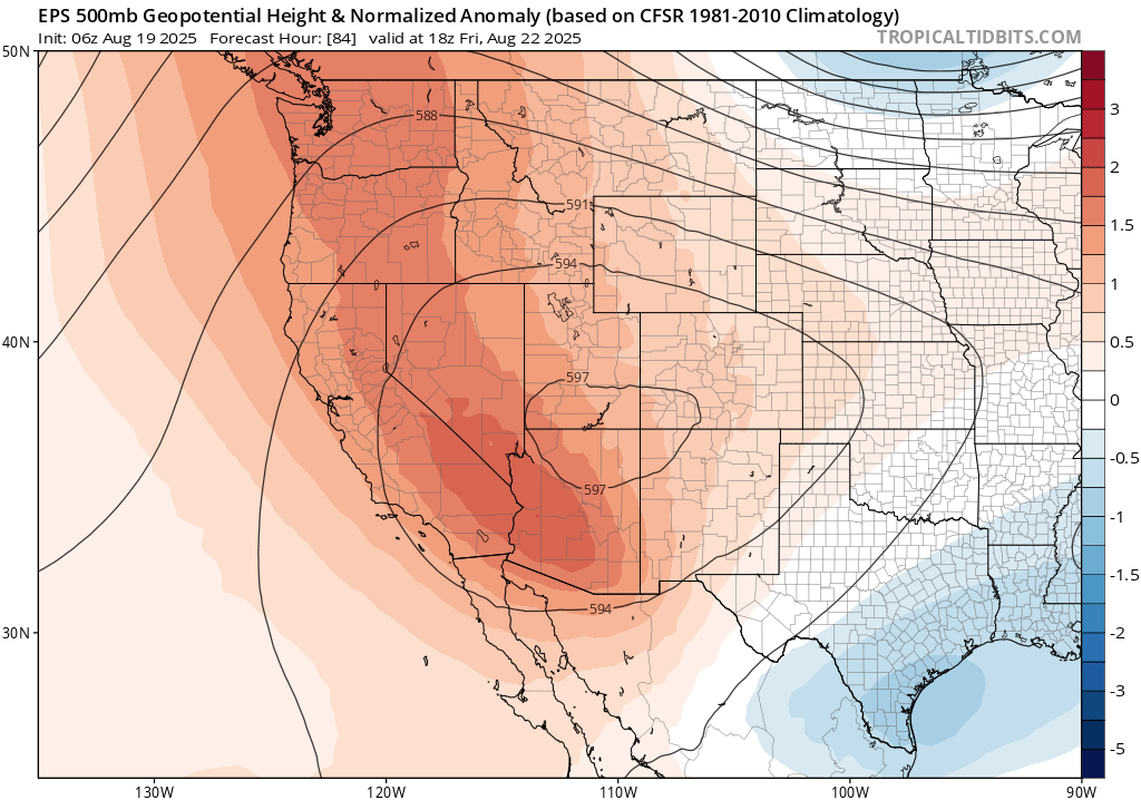
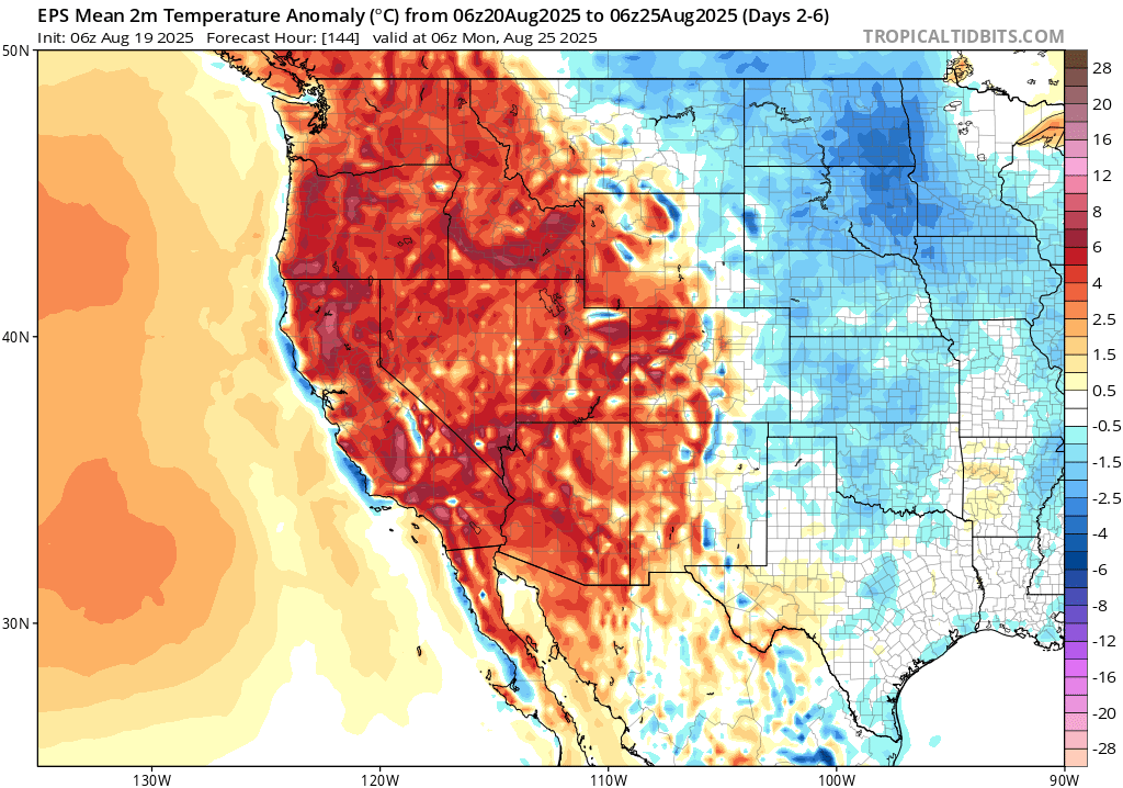
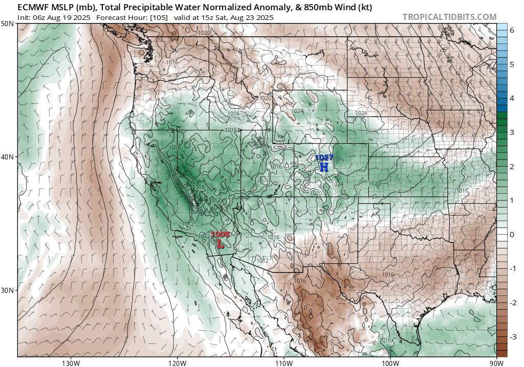
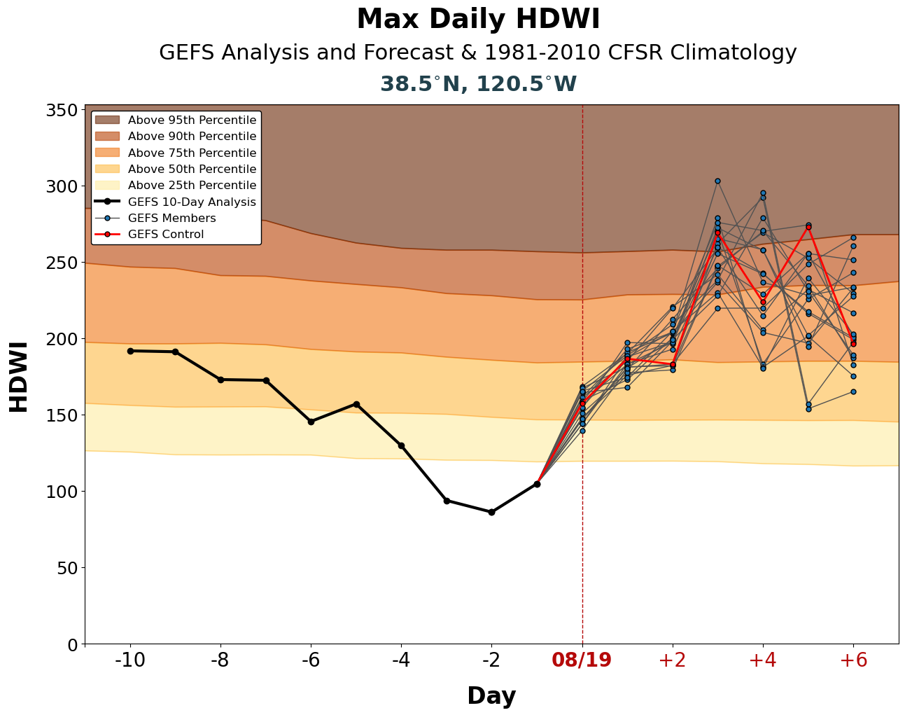
Starting Wednesday, a major heatwave will develop across the Southwest U.S. and extend northward along the Pacific Coast into British Columbia by late week. In some places, especially closer to the coast in California, this will be the hottest/longest heatwave of the season to date. Although this will likely not be an extreme heatwave, it may yet break some temperature records–including daily high temperature records for mid-late Aug in parts of SoCal (possibly including DTLA) and across much Arizona and far more widespread record warm overnight minimum temperatures (possible throughout much of the West, and even including the NorCal coastal region–especially if the recent SST warming trend continues). In fact, this heatwave may be most notably for sustained overnight warmth in some cases, with minimum temperatures not dropping below 70-80 degrees under a strong ridge and amid a relatively humid/cloudy airmass aloft.
Peak heat will likely be from Thursday through Saturday, but warmer than average temperatures will linger into next week and possibly beyond (with the ECMWF ensemble warmer than the GFS ensemble at the moment, and both not fully capturing the recent near-coastal SST warming).
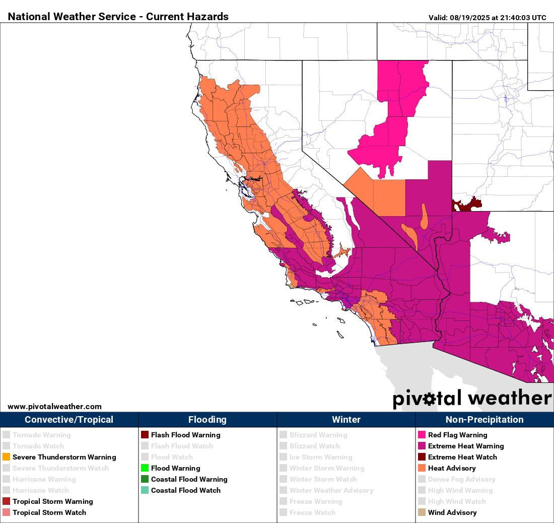
The NWS has, accordingly, issued multiple extreme heat products (watches, warnings, and advisories) for southern/central CA, AZ, and adjacent regions. In places that have not seen significant heat yet this season, especially along the SoCal coastal strip, heat-related impacts may be amplified by lack of acclimation. But in many places, the more notable impacts of this major pattern shift will be with respect to the greatly increased wildfire risk and possibly monsoonal moisture/thunderstorm potential (see below).
Heading into early September, it’s likely that ridging will weaken from this weekend’s peak, but there is presently considerable disagreement between the (ridge-ier and hotter) ECMWF ensemble and the (less ridge-y and cooler) GFS ensemble. We shall see…
For the first time this season, a substantial westward monsoonal push into southern/eastern CA!
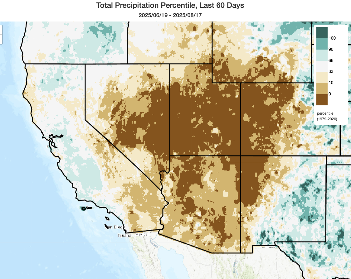
2025 has featured a very weak monsoon on the western fringe of the typical summer wind reversal region–so much so that summer 2025 to date has been among (if not singularly) the driest on record to date across a broad swath of the Great Basin. This anemic start has caused major wildfire activity to persist across NV, AZ, UT, and western CO much longer into summer than would usually be the case during a robust monsoonal moisture/summer thunderstorm regime–and has raised concerns that Great Basin and southern Rockies wildfire risk could persist much later into autumn than was historically typical.
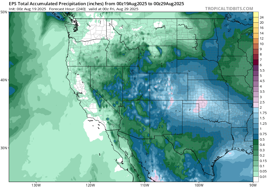
Fortunately, it does appear that a late monsoonal surge will slightly ease these concerns. I don’t expect a dramatic “saved by the bell” moment, but a substantial and more western-oriented monsoonal surge now appears likely over the next 7-10 days across the Great Basin and even extending into portions of southern and eastern California. As the anomalously strong Desert SW ridge expands westward over SoCal, easterly flow aloft will allow mid-upper level atmospheric moisture to overspread the region in the coming days. In these sorts of patterns, there is usually an uptick in mountain/desert thunderstorm activity in SoCal and in the Sierra Nevada–and this week appears to be no exception. There is sometimes also at least a slight chance of some isolated shower/thunderstorm activity “west of the mountains” (i.e., on the coastal side) in this kind of monsoonal easterly flow can persist for long enough, and that too appears to be a possibility in this pattern (especially in its later days). As a result, a range of monsoonal thunderstorm hazards may occur in typical mountain/desert settings into the weekend and beyond (including localized flash flooding under heavy cells, and possible dry lightning/downburst winds posing a fire hazard outside of heavy rain cores; see below).
It’s too early to tell whether or to what degree this activity might make it west of the mountains–most likely in coastal SoCal, but with a very slight chance up in central/NorCal as well. While unlikely, it’s something to keep an eye on given the rising heat and ambient wildfire burning conditions given the potential for some drier lightning strikes. I’ll follow this potential via social media, and YouTube updates, in the coming days.
Sharp uptick in wildfire risk across California, especially SoCal; wildfire activity likely to spike West-wide
This upcoming major heatwave will spike wildfire risk across a broad region of the American West–but especially in Southern California. This will not be a primarily wind-drive wildfire weather event, though breezy to windy conditions are locally quite possible (and there could be some erratic convective winds from downbursts/outflows). The main risk will be a combination of exceptional vegetation dryness and fuel loading in some mountain/desert parts of SoCal (a legacy of a failed-thus-far monsoon, very dry winter/spring preceding, and the wet-dry hydroclimate whiplash event previously discussed from 2024 into 2025, respectively) and rapid fuel drying in some presently less-than-critical regions elsewhere in CA as the longest/hottest heatwave thus far this season persists. In the Great Basin and southern Rockies, where wildfire conditions remain unusually elevated and where multiple large fires are already burning, there will be a mix of fire risk trends through the combined effects of extreme August heat tempered by at least scattered wetting thunderstorm activity.
CA wildfire risk will likely reach its peak during this event between Thursday and Saturday. During this period, very hot (locally record-breaking) temperatures across mountain/desert regions, combined with very dry antecedent fuel conditions, will combine with a conditionally unstable atmosphere (characterized by dry/hot low levels but increasingly humid and buoyant mid-upper levels) to produce ideal conditions for plume-dominated wildfires (i.e., those propelled largely by local and self-reinforcing fire-induced wind currents as opposed to strong ambient winds). This means that any significant local wildfire heat source will likely produce large pyrocumulus or even pyrocumulonimbus (“fire thunderstorm”) clouds–allowing for potentially extreme fire behavior. We last saw this set-up in September 2024, and that event yielded both record-breaking temperatures and multiple destructive wildfires throughout SoCal. Hopefully this occasion will be less eventful, but similar historical events have often coincided with major plume-dominated fire events in SoCal.
In NorCal, conditions are not as dry as in SoCal and wildfire risk will not be as extremely high–but it will still be much higher than it has been recently. And with the coastal zone warming up and clearing out, vegetation conditions will begin to dry out in places where they have thus far remained pretty damp so far this season. So we’ll likely see a NorCal fire uptick in the coming days, as well, though with no major wind events or extreme near-coastal heat expected, the risk will not be as high as elsewhere. But late Aug/Sep heat often sets the stage for more potentially concerning fire weather events in NorCal later in autumn, during stronger wind events–a general sequence with which the upcoming heat would be consistent.
Join me for a YouTube livestream discussing the upcoming heatwave, wildfire risk, and monsoonal surge on Wed @ 3pm PT!
See many of you then (and you will be able to view the recorded version if you can’t catch it live, as always!) As a bonus, I may discuss Atlantic hurricane activity at the end of the session if folks prompt me in the live chat…
Some honest thoughts on 1.5°C as an atmospheric and Earth system scientist
Last week, I published a video focused on my perspective on the 1.5°C temperature target and what it will mean to exceed it. This monologue is an honest (and unvarnished) scientifically-informed personal reflection, so I hope you’ll give it a listen.