Very dry weather across California through mid-December
Despite some recent NorCal precip, conditions remain dry statewide
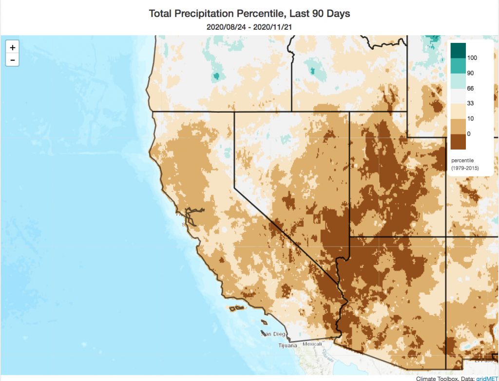
The good news: there has been some rain and snow across most of Northern California over the past two weeks. The higher elevations of the Sierra Nevada have seen a nice blanket of the white stuff, and the typically wet parts of NorCal have seen several inches of cumulative rainfall. In the wettest locations, that precipitation may well be considered “fire season ending”–and rains elsewhere have significantly dampened wildfire risk. But true season-ending rains have still not yet arrived across some parts of NorCal, and certainly not yet across most of SoCal. Indeed–autumn 2020 is shaping to to be among the top-5 driest on record across a wide swath of California. This comes immediately following the warmest August-October period on record in California.
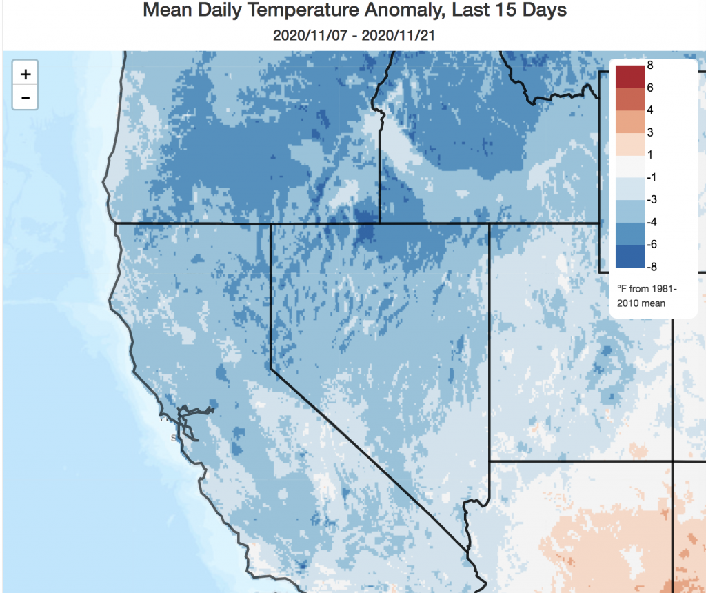
And although temperatures have (mercifully) been slightly on the *cool* side of average for the past couple of weeks, along with some modest NorCal precipitation–it’s quite clear that Fire Season (locally mitigated though it may be) is not going out without a fight. This was illustrated in fairly dramatic (and tragic) fashion last week, when a series of fires along the Hwy 395 corridor broke out amid a severe downsloping windstorm on the lee (eastern) side of the Sierras in far eastern CA/western NV. The worst of these fires was the deadly Mountain View Fire, which exploded to over 25,000 acres over the course of just a few hours and largely destroyed the community of Walker, CA. While lee-side wildfires are not unheard of in late autumn/early winter, fires this large, fast-spreading, and destructive are extraordinary at this time of year and serve as yet another reminder of the extreme dryness and record warmth experienced in 2020.
To summarize: wildfire risk has been greatly mitigated in far NorCal and in the usual wet spots along the western slopes south to about a Monterey to Yosemite line–though occasional fire activity will still be possible here until more widespread heavy rains arrive. South of that, and especially in coastal SoCal, wildfire risk remains quite anomalously high and could become critical under any offshore wind regimes that develop for the foreseeable future. One such moderate event may occur as early as this Thurs/Fri.
Short to medium range outlook: high confidence in a very dry period ahead
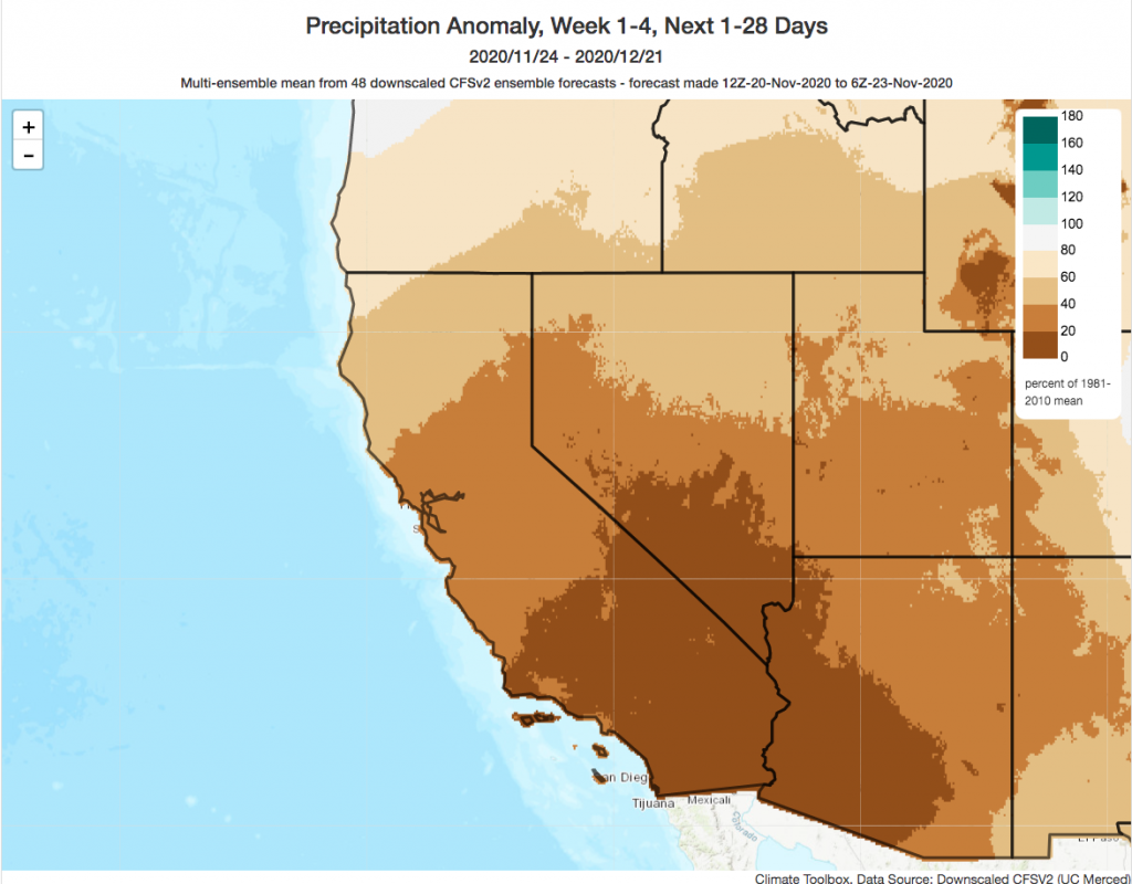
I’m afraid that the next 2-3 weeks look very dry across nearly all of CA. In fact: SoCal may see no precip at all over this period, while even far NorCal may see only 20-30% of average. Now that we’re approaching December, each passing dry week becomes progressively more consequential–as climatological average precipitation increases steadily throughout California from November into December. This potentially prolonged upcoming dry spell will add to already substantial rainfall deficits accumulated both during the autumn and over the calendar year more broadly.
It’s actually somewhat striking just how high confidence in a prolonged dry spell is across all the major model ensembles. Some individual ensemble members from the ECMWF and GFS are completely dry through mid-December for all of California. While I don’t think that’s especially likely, it is not out of the question and the odds of an unusually dry period are very high.
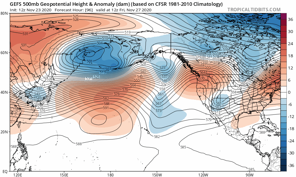
Assuming this evolution comes to pass, I think it’s fair to say we’ll be entering “resilient ridge” territory. I’m not quite willing to dig out the “ridiculous” modifier again just yet–but it’s not out of the question that’ll happen later this winter given the seasonal outlook. Interestingly, it appears that the storm track over most of the North Pacific will be quite active over this period–it’s just that the cyclonic activity south of Alaska will be in exactly the right position to produce episodes of successive ridge-building along the West Coast for the foreseeable future–keeping California (and much of the West, really) dry for some time to come).
Long-range: still looks pretty dry
I don’t really have much good news to pass along for the month of December. Right now, both traditional dynamical ensemble predictions and experimental statistical outlooks point to high odds of a substantially drier-than-average month across California–especially the southern 3/4 of the state. Given the already moderately strong La Nina event ongoing in the tropical Pacific, and predictions of further strengthening into “strong” territory, I don’t really see any reason to doubt these outlooks. That said: “drier than average” does not equate to a total shut-out in the precipitation department. There should eventually be more rain and snow across California this winter. But when all is said and done, the odds that the seasonal total will be below average looks pretty high–and increases with each passing dry week.
New research highlight: Increasing population exposure to flood risk due to climate change
It feels a bit strange to be talking about flood risk in the midst of a deepening drought across California, but if we’ve learned anything from 2020 it’s that extreme event risk mitigation is most effective when it’s done proactively–before the proverbial horses have left the barn, so to speak. So while flood risk in California may be near zero for the foreseeable weather future, there’s no time like the present to consider future possibilities.
My colleagues and I recently published new research on increasing flood risk across the contiguous United States as a result of climate change-caused increases in extreme downpours. By combining a large climate model ensemble with a high-resolution hydrodynamic model, we estimated the frequency and severity of future floods and quantified the population exposed to these potentially larger and more extensive future events. We find substantial increases in extreme precipitation events–and, strikingly, that largest projected increases occur for the very largest events (downpours or storm sequences with recurrence intervals of 50-200 years). These increases translate into widespread and potentially large increases in the number of people potentially affected by severe flood events in a warmer climate–though the exact extend depends strongly upon both how much warming actually occurs and future urban development patterns. These increases in potential flood risk are quite substantial in California–which is consistent to a growing body of prior work suggesting that the region is likely to experience both more severe droughts and flood events in a warming climate.
Our research is focused broadly across the entire contiguous U.S., but there are some California-specific numbers and maps available in the paper and its supplements. For those interested, this paper is fully open access and may be downloaded directly from Earth’s Future here. I also wrote an extensive accompanying Twitter thread. Many thanks to my colleagues at the University of Bristol (Ollie Wing and Paul Bates), the Capacity Center for Climate and Weather Extremes at the National Center for Atmospheric Research (James Done), and the Nature Conservancy (Dick Cameron and Kris Johnson) who made this collaboration possible!
Very dry weather across California through mid-December Read More »