Modest late-season rain headed for California; powerful El Nino event may be brewing in the Pacific
Recent Weather Summary
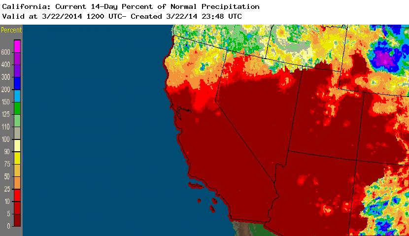
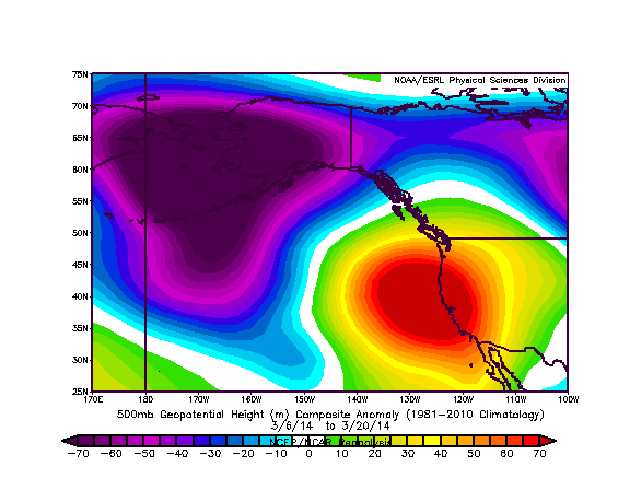
Unusually warm and dry conditions–which have been prevalent throughout California for the past 15 months (with a couple of major, if brief, exceptions)–have once again been the dominant feature of our weather over the past couple of weeks. Occasional record-high temperatures and far-below-normal precipitation have been observed across most of the state for much of March, although the northernmost part of the state has fared better in terms of precipitation as a series of modest cold frontal passages brought light to moderate precipitation to coastal areas. Interestingly, a fairly persistent region of high pressure has once again developed over the northeastern Pacific–a familiar pattern reminiscent of the Ridiculously Resilient Ridge that has been widely recognized as the proximal cause of California’s current drought. However, the good news is that unlike in recent months, the current ridging appears to be far less resilient, and will largely break down over the next few days. Most of California will experience two more days of warm and dry weather before a significant shift to wetter and more unsettled conditions occurs later this week, especially across the north.
Drought Update: Still exceptionally dry out there
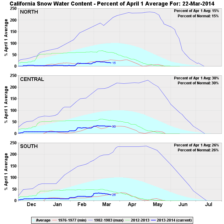
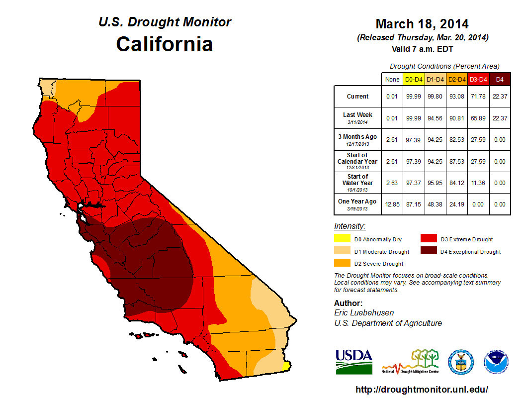
After February’s welcome rainfall brought California the first month of near-normal precipitation in over a year, March is once again tracking well below average. Sierra snow water equivalent–despite receiving a substantial boost by February’s storms–is once again at record-low levels, and in the Northern Sierra is beating the previous record low (set in spring 1977) by a considerable margin. The most recent Drought Monitor update depicts a re-expansion of “extreme to exceptional” drought conditions in Northern California after brief excursion during February into merely “severe to extreme” territory. While beneficial late-season precipitation is expected over the next 1-2 weeks (at least in NorCal), California’s rainy season is already winding down: climatologically speaking, 90% or more of California’s Water Year precipitation normally falls by late March. Therefore, barring a truly exceptional barrage of extreme precipitation events between now and May (which, I would like to emphasize, is extraordinarily unlikely), it appears that California’s ongoing extreme drought is unlikely to be substantially alleviated before next winter.
Welcome late-season precipitation over next 10 days
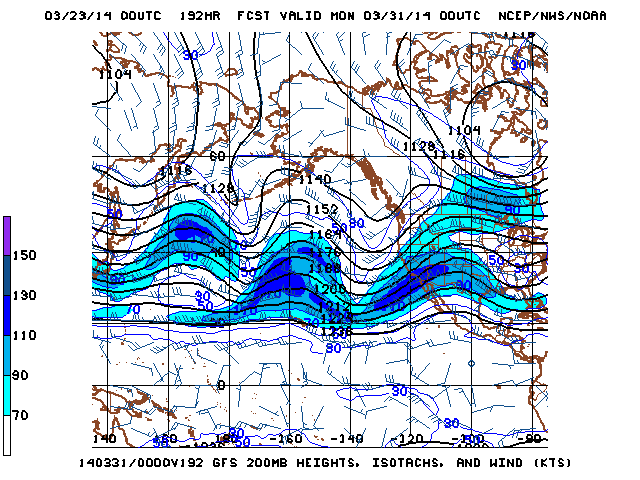
There is a bit of good news in the short term: the East Pacific ridging will break down in the coming days and allow a series of late-season storms to bring beneficial rain and snow to at least the northern half of the state over the next 5-10 days. Heavy precipitation is not expected; however, many areas are likely to experience a good soaking. Given the time of year (suggestive of a high sun angle and higher surface warming potential by solar radiation) and the relatively cold origin of the incoming, there will most likely be at least a slight risk of thunderstorms with each of these systems, and it’s possible that there could be slightly more widespread coverage at some point between now and early April. There is some suggestion that ridging will return once again after that, which is unfortunately a favored outcome as we get this late in the season.
Big changes in the equatorial Pacific: is the Big One on the way?
The meteorological community has been abuzz over the past couple of months regarding the possible development of a significant El Nino event in the tropical Pacific Ocean in 2014. The first hint that something interesting might be going on in the Pacific occurred all the way back in December 2013, when some of the long-range coupled ocean-atmosphere models were suggesting the potential for elevated sea surface temperatures by spring 2014. Of course, it’s necessary to have a healthy dose of skepticism regarding ENSO projections that far in the future, especially when one is on the wrong side of the so-called “spring predictability barrier.”
Since January 2014, however, observational evidence from buoys and Earth-observing satellites have started to paint an increasingly coherent and eyebrow-raising picture of the recent evolution of the coupled atmosphere-ocean system. A series of westerly wind bursts that occurring initially in the West Pacific have recently started to occur further east in the Central Pacific, which is acting to push much of the very warm water that has accumulated in the West Pacific since the last big El Nino event toward the east. In fact, buoy data suggests that a huge slug of anomalously warm water below the ocean surface is moving rapidly eastward and slowly beginning to surface in the East Pacific. At the time of this writing, a new westerly wind burst appears to be developing, which finally push East Pacific SSTs above normal.
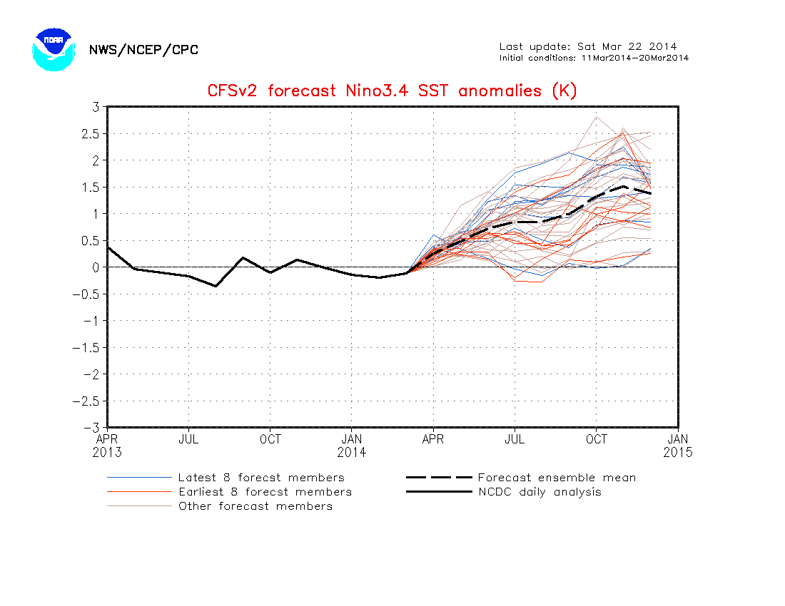
All of this evidence–combined with the fact that the dynamical models have become increasingly bullish regarding the development of a significant SST anomalies by mid-summer 2014–suggests that El Nino conditions will probably develop over the next 3 months. Since the observed subsurface anomalies are currently larger than those that preceded the previous strongest event on record (the 1997-1998 event), there is good reason to believe that the potential exists for a powerful El Nino event to occur during 2014-2015.
While it’s still too early to be confident in a specific prediction that strong El Nino conditions will occur this year, I think it’s safe to say that the chances are better this year than in any other year since 1997. It’s still possible that the ongoing series of westerly wind bursts suddenly die off and mitigate the incipient event (similar to what happened in summer 2012), but at this point I’d say that all signs point to a continued evolution toward El Nino conditions.
© 2014 WEATHER WEST
