Powerful El Nino likely to bring heavy precipitation—and possible flooding—to California over the next several months
Summary of recent conditions
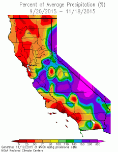 There continues to be much conversation surrounding the relative lack of major storms in California so far this autumn. Precipitation so far this season has been somewhat below average across the more populated coastal parts of the state, although very early Sierra Nevada snowpack numbers are actually looking pretty good at the moment. Temperatures have (finally!) cooled from their record-shattering October values, and have been fairly close to average over the past couple of weeks.
Recent modest rains and cooler temperatures, though, have so far done little to mitigate California’s worst drought on record. Iconic drought-related milestones are still being reached, from Folsom Lake’s all-time record low level to the recent discovery that as many as 20% of California’s trees could eventually die as a result of the drought and bark beetle stresses already experienced.
Interactions between El Niño and the jet stream’s seasonal cycle
Should we be worried that California has yet to experience an epic deluge so far this fall? What happened to the ostensible “parade of storms” that is so often talked about in the context of major El Niño events? I would argue that the most appropriate answers to these questions are “no” and “it’s coming,” respectively.
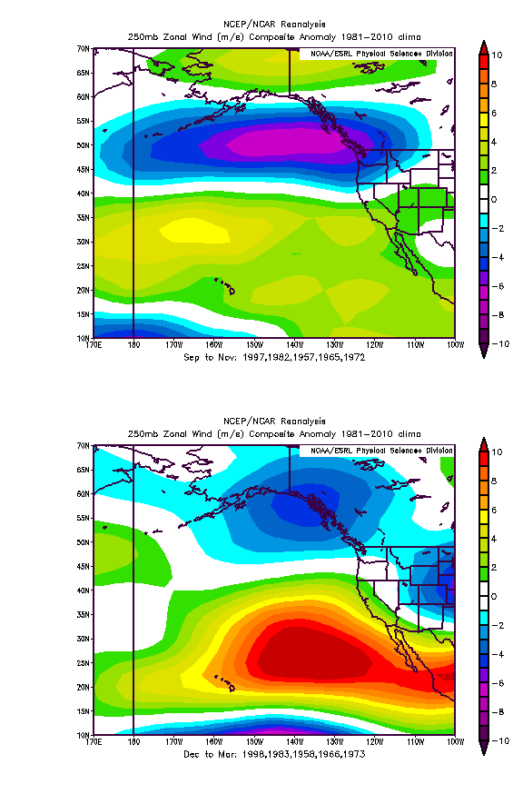
After four consecutive years characterized by a remarkable lack of storms in California at any time of year, it’s easy to forget that the autumn can be an extremely variable period from a meteorological perspective. Transitions seasons (autumn and spring) in tend to be highly volatile throughout the Earth’s middle latitudes as cold, dry polar and warm, moist tropical airmasses interact with high frequency. But California is a bit unique in the sense that it lies near the southern margin of the Pacific jet stream, and is therefore quite susceptible to relatively subtle shifts in the storm track. This is especially true during the September to November period, as during these months the Pacific jet stream is often quite strong but tends to be focused well to the north of the state, up in Washington and the Pacific Northwest. California does sometimes experience major storminess this time of year due to transient, temporary shifts in the jet, but in general sustained wet periods are the exception rather than the norm.
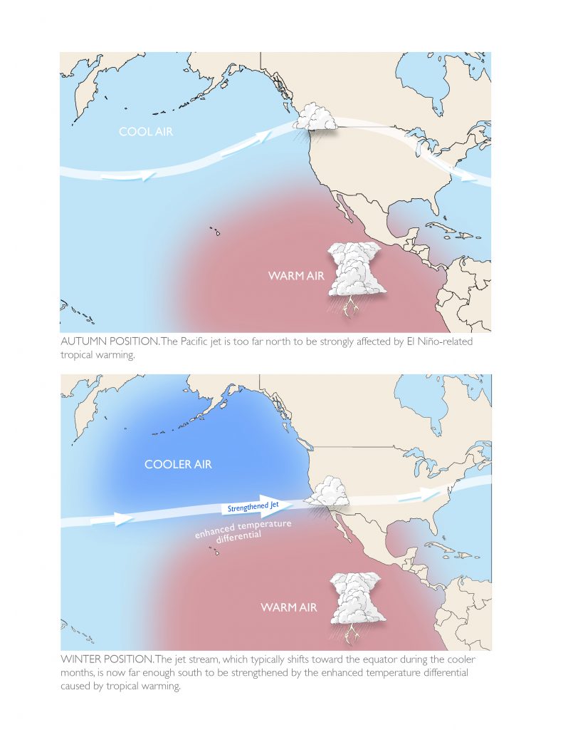
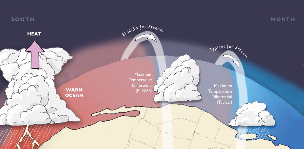
Since the west-to-east flowing jet stream is fundamentally driven by the large temperature differences that exist between the warm equatorial region and cold polar region, its location, strength, and trajectory depends strongly on the orientation and magnitude of temperature variations across the Earth’s surface. With the approach of winter, temperatures in Northern Hemisphere begin to cool more rapidly—and the region of maximum north-south temperature differential over the Pacific Ocean starts to shift southward. The net result: the jet stream’s typical latitude from December through March is much reliably further south—and closer to California—than during the autumn.
Why is this seasonal cycle critically important during an El Niño year? Well, the primary means by which El Niño affects California precipitation is by enhancing the low-latitude (subtropical) branch of the jet stream. The subtropical jet stream is not always a totally distinct feature in the weather charts—it tends to be weaker and more discontinuous than its more robust northern cousin (the subpolar jet). Sometimes, the subtropical jet is not discernable at all in a particular region, and at other times it effectively merges with the northern stream. But during major El Niño years, the subtropical jet over the northern Pacific Ocean tends to be stronger, better defined, and further to the south.
This strengthening and southward shift of the subtropical jet during El Niño occurs primarily because strong warming of an already warm region (the eastern tropical Pacific) tends to enhance the north-south temperature differential across the Pacific basin. Heat from anomalously warm ocean temperatures is transported vertically and eventually northward by unusually active tropical convection (thunderstorms), warming the upper atmosphere in the lower latitudes. (Climatological sidebar: this effectively leads to a regionally-enhanced Hadley Cell circulation). Anomalous El Niño-induced upper-atmospheric warming occurs only so far north, and during the autumn months the jet stream tends to be too far north to “take advantage” of this strong lower-latitude temperature gradient. As the jet shifts southward during winter, however, the subtropical branch of the jet is in a favorable position for intensification. It is this effect that can bring California its infamous “parade” of winter storms—and, in some years, excessive precipitation and eventually flooding and mudslides.
One sentence summary: A strengthened subtropical jet stream—which is the primary means by which El Niño brings increased precipitation to California—is unlikely to occur prior to winter due to the intrinsic seasonal cycle of temperature variations across the Pacific Basin.
El Niño now appears to be strongest in modern observational record
Over the past 8 or 9 months, there has been a lot of animated discussion over whether the tropical Pacific could possibly warm as much as was being indicated by the dynamical models. A more than +3C anomaly—which was foreseen by most of the flagship international seasonal forecast models (like the American CFS and the European ECMWF), seemed, to many atmospheric scientists, to be an implausibly high outcome. Even in recent weeks, there were concerns that the critically important Niño 3.4 region may have “leveled off,” or perhaps had already peaked.
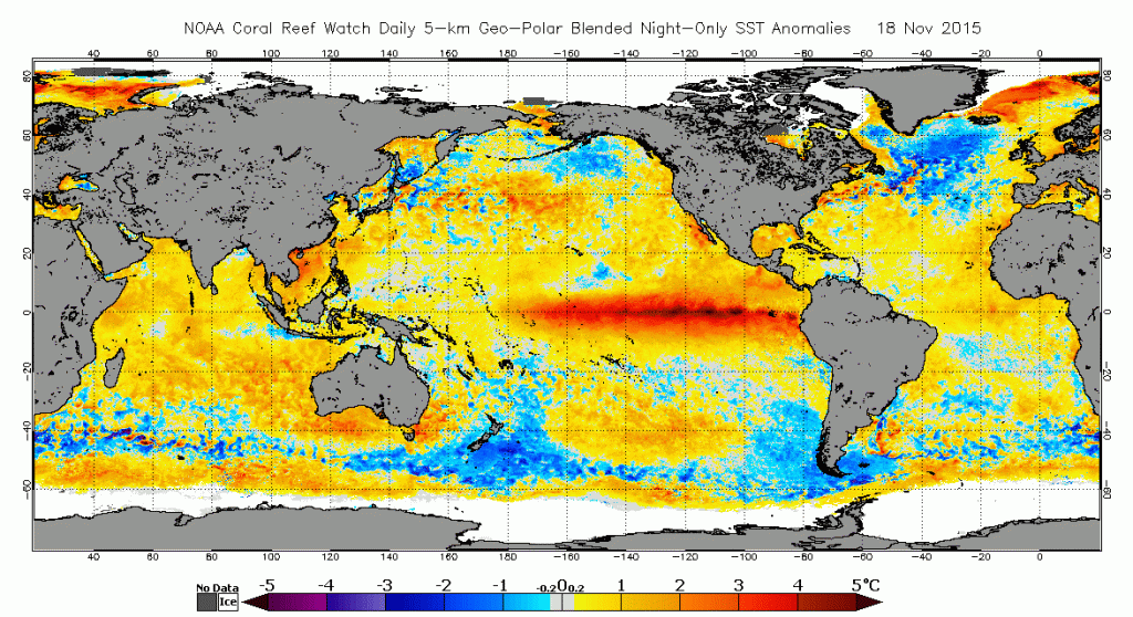
Those concerns ultimately turned out to be unfounded, as earlier this week ocean surface temperatures in the canonical Niño 3.4 region reached 3C above average for the first time in recorded history, validating dynamical model forecasts made many months earlier. This weekly value exceeds the maximum weekly value recorded even during the so-called “super El Niño” events of 1982-1983 and 1997-1998. While El Niño impacts do not correlate directly with the magnitude of SST anomalies in any particular section of ocean (and we’re still some way off from an all-time record 3-monthly peak), this is still a major geophysical milestone—and one that has significant implications for the coming winter in California.
El Niño continues to pick up steam, sets a weekly record https://t.co/JGh8JcRfY0 pic.twitter.com/hvZtdrlY1c
— Climate Central (@ClimateCentral) November 20, 2015
Outlook for California Winter 2015-2016
Top-tier El Niño conditions are now an observational reality, not a prediction. As discussed above, we are now approaching the time of year when El Niño’s influence upon the Pacific storm track tends to be more pronounced. So, with that in mind, how does the upcoming winter look?
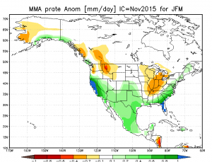
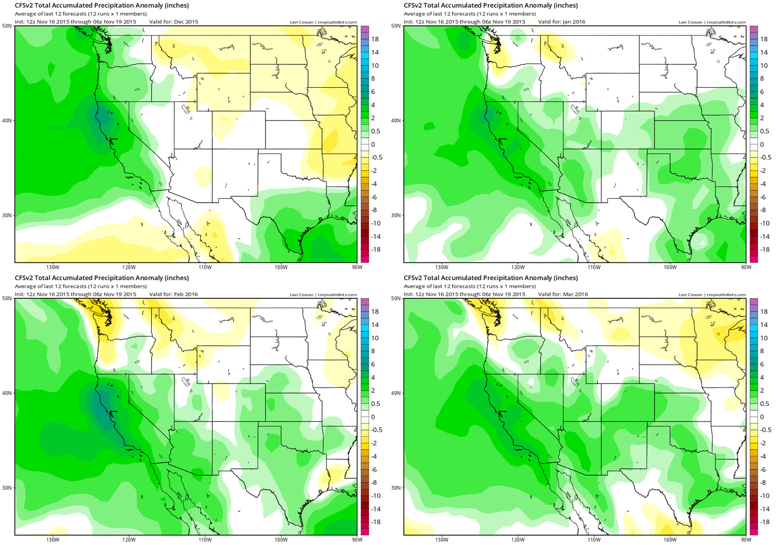
In a word: wet. In fact, it’s hard to envision a set of mid-November observations and model output that would lead to higher confidence in a wetter-than-average California winter than the ones currently in place. The latest dynamical model forecasts are calling for well above average precipitation throughout California during the January-March period, and the recent forecasts from the CFS model have shifted towards a wet December as well. These same models are suggesting a large-scale atmospheric pressure pattern that is strikingly similar to that which occurred during California’s wettest historical winters (including the 1982-1983 and 1997-1998 El Niño events).
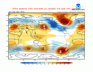
Ultimately, it is this latter point that matters more for the conditions that might evolve later this winter. While the models used for seasonal forecasting incorporate the same basic physics as those used to predict day-to-day weather, for reasons of computational efficiency they do not have anywhere near the same spatial resolution as weather models. This means that seasonal forecast models can’t resolve California’s complex topography (in fact, in most of these, the Coast Ranges don’t even exist, and the Central Valley is part of a gradual upward slope toward the Sierra Nevada). Ultimately, this makes it impossible for seasonal forecast models to accurate simulate the dramatic orographic enhancement that occurs in California’s mountainous terrain during major storm events. Seasonally simulated precipitation anomalies, therefore, are very likely lower bounds on what might actually fall during the coming winter if the simulated atmospheric setup actually occurs.
It’s not possible, at this point, to be more specific about how much rain might accumulate in California this winter. But previous top-tier El Niño events have brought annual totals on the order of ~175-200% of average in many spots—and this number is consistent with recent forecasts made by the CFS.
Heavy seasonal precipitation totals don’t always lead to major flooding if there are substantial breaks between incoming storms. In fact, some of California’s most widespread and most damaging individual flood events did not occur during El Niño years. But in general, high seasonal totals mean that heavy storms are more likely to coincide with wet/saturated antecedent soil conditions, and El Niño-induced increases in storm frequency make it more likely for several intense events to occur in rapid succession. Thus, flood (and mudslide) risk will likely be greatly elevated this winter, and certainly will be higher than it has been in the past five years. This risk may also be enhanced by the legacy of California’s ongoing, record drought. Chief concerns include increased flash flood/debris flow risk near high-intensity wildfire burn scars and increased risk of levee failures and river flooding due to dramatic land surface subsidence in the Central Valley.
Very strong El Niño + record warm Pacific = wild California winter
The eastern tropical part of the Pacific basin is extremely warm due to El Niño, but oceanic warmth further to the north has been even more anomalous in recent months. Virtually every ocean temperature record in existence for the northeastern Pacific has been shattered over the past six months or so. As I’ve discussed previously, some of this incredible warmth has to do with the present El Niño event, as well as dissipated energy from the “El Niño that wasn’t” in 2014. But it’s also broadly believed in the scientific community that at least some of this phenomenal Pacific Ocean warmth is due to Earth’s long-term warming trend.
The super-warm North Pacific has the potential to add extra moisture to the atmosphere this winter. While this more generalized warming is unlikely to affect the frequency of storms, it may well act to add “extra juice” to incoming systems this winter. When we consider this effect in combination with the likely increase in storm frequency due to El Niño, it’s clear the potential exists for a very active winter overall.
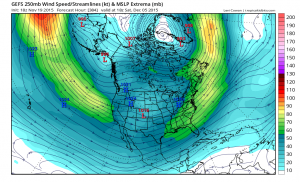
There are currently some early signs of the long-awaited shift towards a more southerly and zonally (west-to-east) oriented jet stream over the next few weeks as we head into December. Various model forecasts are suggesting an imminent transition from the present “wavy jet” configuration to a more consolidated one reminiscent of the classic El Niño pattern. In the lead-up to this pattern shift, Californians should probably expect highly variable conditions (and rather unreliable weather forecasts in the short term), as these kinds of transitions are notoriously hard to capture. But there is now pretty high confidence that a fairly dramatic change in the weather is on the horizon—most likely days or weeks, rather than months, in the future.
Finally, it’s important to point out that the planet has experienced nearly 20 years’ worth of global warming since the last big El Niño event in 1997-1998, and nearly 35 years’ worth of warming since the 1982-1983 event before it. In general, this means that there’s more moisture over the world’s major ocean basins than there used to be—which can increase the potential intensity of precipitation when it does occur. But other more complex changes have occurred in the coupled ocean-ice-atmosphere system over the past four decades that are harder to quantify, and may have less obvious (and less predictable) impacts upon overall Pacific climate. These influences could hypothetically add to (or subtract from) the overall impact of El Niño in California in the future.
Despite these added uncertainties, however, it appears quite likely that the present El Niño will exert a powerful (and likely dominant) influence upon California weather this coming winter. There has never been a year in California’s history with this much advance warning regarding the potential for very heavy precipitation, and there is still time for individuals and government agencies to take steps to mitigate the related hazards likely to emerge in the coming weeks and months (fortunately, all evidence suggests that the relevant authorities are taking this El Niño seriously). And—as California’s state government and water agencies have gone to great lengths to emphasize—even a very wet winter in California is unlikely to erase the profound effects of California’s multi-year drought. In many ways, the present situation resembles a conundrum that the Golden State is likely to face more often in the future: how to manage a greatly increased risk of extreme precipitation and flooding despite the presence of long-term water deficits.
One sentence summary: One of the strongest El Niño events on record will very likely bring a wetter than usual winter to California, and there will be a substantially increased risk of heavy precipitation events and associated flooding.
Special thanks are due to artist and naturalist Emily Underwood, who distilled several complex geophysical concepts into two beautiful scientific illustrations produced specifically for this post.
© 2015 WEATHER WEST