Major early-season heatwave across interior NorCal early next week; extreme drought continues to worsen
Relative cool reprieve may be ending, especially away from coast
The last couple of weeks have featured rather comfortable conditions across much of California, with near average temperatures (even slightly cooler than average) temperatures along the immediate coast due to chilly near shore ocean temperatures and a robust marine layer. Rather dry and cool low pressure systems have repeatedly brought bouts of mainly light mountain showers in recent days–not hydrologically significant precipitation by any means, but still welcome. There has been a notable lack of hot temperatures even across inland areas, as well.
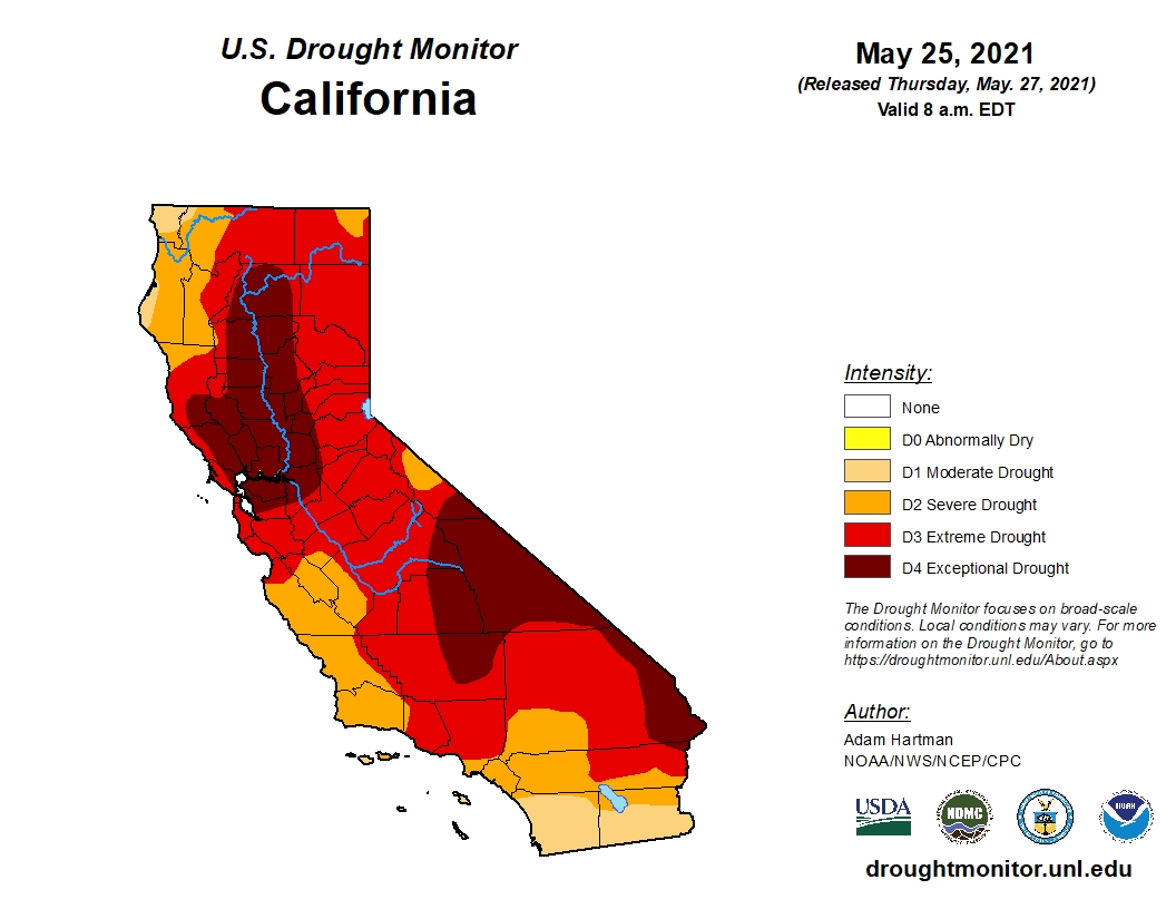
All of that is about to change pretty dramatically as a major pattern change develops along the West Coast. But first, I just wanted to update everyone on the status of the drought. As will be a surprise to absolutely no one reading this, the drought in California is already quite severe, and continues to worsen. The Drought Monitor, the useful (if imperfect) drought monitoring tool put out by UNL and the USDA, suggests in its most recent update that much of Northern California is now experiencing “exceptional drought”–a step above “extreme drought,” and the highest possible drought designation. Many folks in NorCal will point out that some of the more subjective drought monitoring tools and metrics may just be catching up to reality–streamflow, soil moisture, and vegetation dryness have been at record dry levels for some time already. But the steady ramp up of these formal drought classifications has been generating an increasing level of public attention, and for good reason: conditions across a large portion of Northern California are already drier than they were at the *peak* of the 2013-2016 drought, and we’re just now entering the long dry season. Snowpack, such as it was, is now “officially” gone–with less than 0.5% of average remaining. That is an exceptionally early total melt-out, and even more concerningly this very rapid melting apparently contributed very little to runoff on CA’s rivers and streams.
I won’t belabor the increasingly obvious point about the potential for exceptional wildfire risk and behavior, especially in NorCal and especially in/near forests from August through October. But I really do recommend that people be as prepared as they can be for what could be quite a serious wildfire season. Whether or not we see as many extremely large and destructive fires as we did in 2020 remains to be seen. I am reasonably optimistic that last year remains an outlier, even by 21st century climate-changed standards. But we very well could see behavior on individual fires that matches/exceeds last year as vegetation is even drier than it was a year ago. And if we see any major dry lightning outbreaks in the next 5 months–watch out.
Major, possible record-breaking heatwave across NorCal Sun-Tues
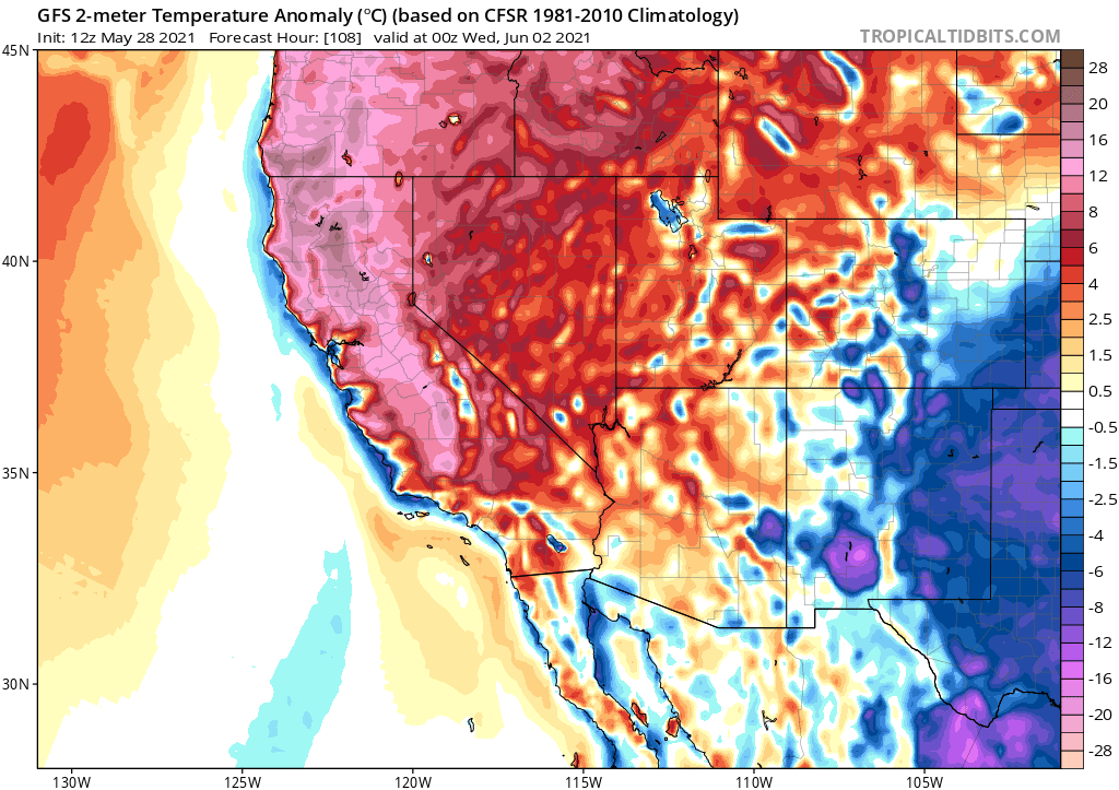
Well, the cool weather reprieve is officially coming to an end. Strong high pressure will build along the West Coast this weekend, bringing a dome of very high 500mb geopotential heights and downward motion in the atmosphere. This will produce a very hot early season airmass over the NorCal interior that will try (with only modest success) to spread toward the coast. Monday and Tuesday will likely feature the first triple digit temperatures across the Central Valley this season, and some spots could approach 110 in the hotter locations. Many places will likely see their hottest Memorial Day on record across NorCal, and a handful of locations could even set new May monthly temperature records. This will be a pretty sudden transition from relatively mild to very hot temperatures in some places, so the potential for heat-related illness will be a bit higher than usual for temperatures of this magnitude as well.
SoCal will be warm, but not nearly so anomalously hot as NorCal and I don’t expect record temperatures in the southern part of the state during this event.
As noted previously, vegetation is already at mid-late July-like dryness levels–so fire risk will be much higher than usual for a late May heatwave. No significant winds are expected, so fire risk probably won’t be extreme, but fuels are now dry enough to sustain very active fire behavior during hot/dry conditions just about everywhere–so be careful out there.
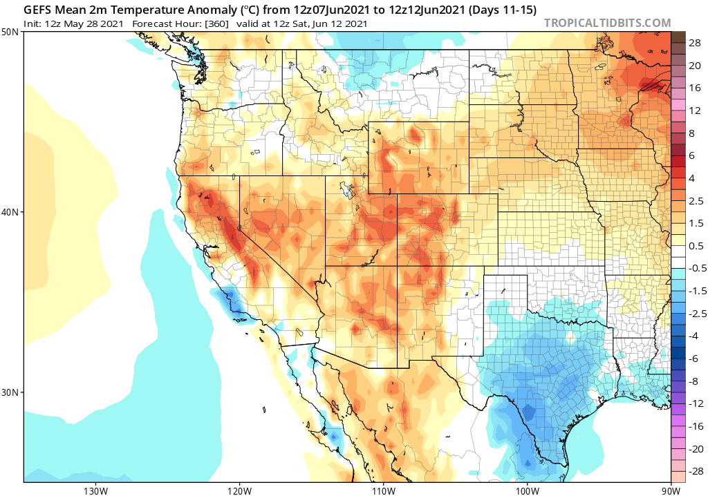
Cooler by mid-June, but still warmer than average?
We have, unfortunately, reached the time of year when I usually don’t bother discussing precipitation chances unless something unusual is going on. Right now, there’s nothing on the horizon. At the moment, multi-model ensembles do suggest that temperatures will decrease somewhat from their early June record levels–cooling nearly statewide. That said, warmer than average temperatures may persist across most of the CA interior, with continued cool conditions along only the immediate coast as cool near-shore SSTs persist.