Stormy and cold pattern across California, and the broader West, through mid-December.
Notably cool conditions continue across California and PacNW this month
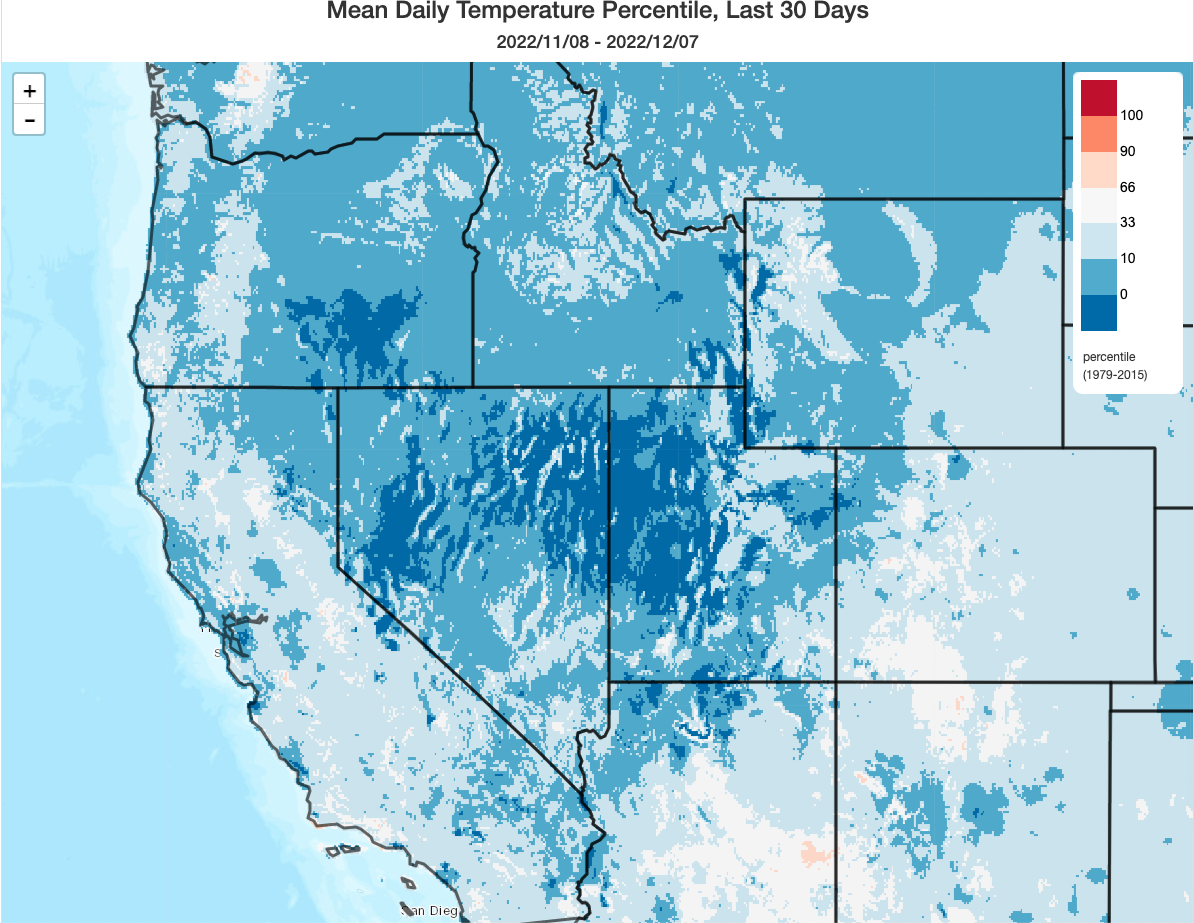
As noted in the last blog post, a notably cool streak has continued across most of the Western U.S. over the past month. This has included some significant snowfall to near sea level as far south as Washington and parts of Oregon as well as persistently cold temperatures in other areas. In fact, in some parts of the interior Great Basin, the past 30 days appear to have been the coldest such period in the past 40 years or so. In California, conditions have not been quite so anomalously cold in relative terms–but it has still been among the top 10 coolest Nov-early Dec periods since the late 1970s, which is especially noticable given how much record warmth this part of the world has experienced in recent years.
Multiple significant, cold, and classic winter storms over the next 7-10 days
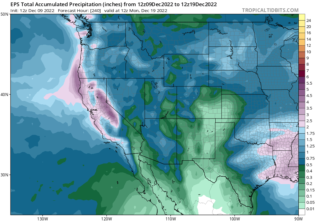
A couple of robust “good old” winter storms will affect essentially all of California over the next 7-10 days. The first and possibly strongest of which is due in this weekend: essentially taking the form of a moderate-strength, cold atmospheric river. This event will feature a classic cold frontal passage, complete with locally strong and gusty winds, moderate to heavy rain near the time of frontal passage, and perhaps some isolated thunderstorms along/behind the front. Very heavy snow rates can be expected to relatively low elevations–not just in the Sierra and northern Mountains, but also in the higher elevations (above 3,000-3,500 feet or so) of the Coast Ranges and Transverse Ranges–leading to widespread mountain travel disruptions this weekend.
Dynamics (jet positioning and curvature) and thermodynamics (instability) will both be pretty favorable for a fairly intense cold frontal passage, which may feature a NCFR (narrow cold frontal rainband)-type feature, especially in NorCal. If a NCFR develops, it could produce a brief period of enhanced winds, torrential rainfall, and perhaps isolated lightning. This band could produce some minor urban/stream flooding in NorCal, but overall flood risk is expected to be low. The only other exception will be some of the recent wildfire burn areas in California, which could see a modest flash flood/debris flow threat if one of these heavier bands spends a significant amount of time over one of those regions.
And speaking of SoCal: this will be a decent rain event for much of the southern third of the state, although probably not an especially dramatic storm. So the vast majority of the California should get pretty soaked (or snow buried, depending on elevation) by this one–a nice statewide soaker right when we need it. (But if you’re planning on driving over even the lower mountain passes in northern or central CA this weekend–good luck, and consider rescheduling.)
An additional (likely) cold storm or two will likely follow this weekend’s late next week into the following weekend, but details are quite uncertain at the moment for reasons discussed in further detail below. Overall, I would expect a generally cold and unsettled pattern to continue across most of California for the next ~10 days or so.
An Arctic “atmospheric traffic jam:” high latitude blocking leads to wild weather across North America and beyond
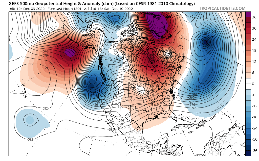
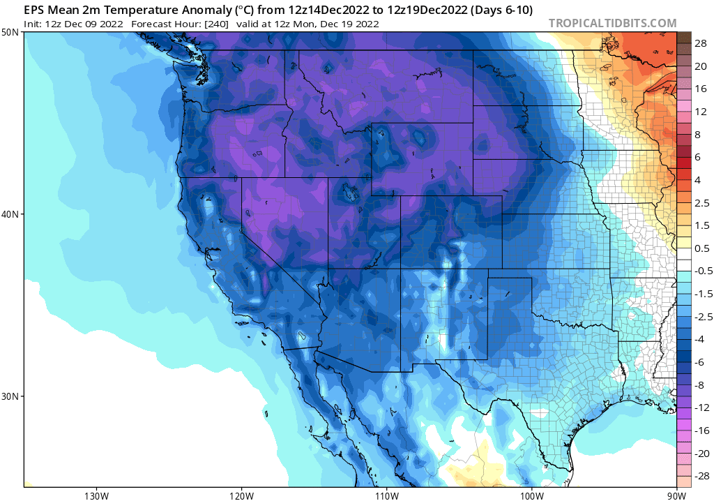
The proximal upstream cause of the upcoming cold and stormy weather in California in this instance is pretty interesting and fairly unusual. In recent days, a pair of extremely anomalous high pressure systems (i.e., blocking anticyclones) have set up in or near the Arctic: one over Greenland, and the other over (or just south of) Alaska. These high pressure systems have led to record-breaking and extraordinary warmth in the planet’s high latitudes–including some rather astonishing well above freezing temperatures well into the Arctic Circle (and subsequent very heavy/record breaking snowfall in moister places like Anchorage, AK).
But these blocking ridges are now dramatically perturbing the polar jet stream and overall atmospheric flow pattern over the entire Northern Hemisphere. A very unusual and persistent outbreak of Arctic air will occur over the interior western and central portion of the U.S. and Canada in the coming days–leading to a possible mid-winter tornado outbreak in parts of the Midwest or Deep South as warm/moist air interacts with the sharp polar front as well as a major blizzard across the Northern Plains. This is because the “tropospheric fence” (i.e., the jet stream) that usually holds bitterly cold air in the Arctic is buckling in the short term–its wild, looping excursions will bring very cold weather to some parts of the mid-latitudes and very warm weather elsewhere (as well as regions of persistent storminess in between).
California will be on the western fringe of one of these “cold lobes”–which is why the state is going to see at least a couple bouts of substantial storminess and quite chilly conditions. But because the atmospheric flow pattern is so loopy and anomalous, it’s going to be really hard to nail down the forecast details more than a few days in advance right now. There are so many instabilities with this kind of jet stream configuration that even the model ensembles may struggle to coverage on any particular pattern for a while. Thus, there are a wide range of potential outcomes following this weekend’s high confidence strong and cold storm–from lots of additional rain and snow to a very cold (but mostly dry) to largely mild and dry conditions. There may even be some fairly wild swings back and forth between these conditions over the next couple of weeks as the Arctic Oscillation enters strongly and persistently negative territory. But it certainly appears that we’re going to add substantially to the already quite healthy snowpack in California over the next 10 days–which is certainly good news from a short-term drought mitigation perspective.
Also worth noting: it is possible that due to the southerly-displaced jet stream next week, subsequent storms may actually favor SoCal more than NorCal (essentially a “jet undercutting” scenario). How significant those potential systems may become is too early to say, but this is the kind of setup that can produce significant rainfall across the southern third of the state if they can tap into subtropical moisture. Speculative for now, and will depend on exactly how the pattern evolves, but stay tuned!
Some hints of calmer and less cold weather toward late December (and beyond?)
As noted above, there is still considerable uncertainty in the long range (looking toward the end of December). The topsy-turviness of the high-latitude blocking pattern is just too great to have much confidence in the pattern beyond the next week at the moment. That said, there are indications that the high-latitude blocks will probably break down toward the end of December–and if that happens, the pattern over western North America would probably return closer to its baseline “moderate La Nina” configuration. Model ensembles are (weakly) hinting at this in late December, which would bring much drier and probably at least somewhat warmer conditions toward the end of the calendar year (though with damp soils and much snow on the ground in the mountains from upcoming storms over the next 7-10 days).
Looking beyond the end of December, multi-model ensembles continue to indicate a higher than usual likelihood of a drier-than-usual Jan-May “back half” of the California wet season–as they have been for several months. But the signal is actually a bit weaker with the early December ensemble suite update–and there are now a couple of dissenting individual models within the ensemble (compared to near unanimity in the last cycle). So, at this point, I would continue to lean toward drier than average conditions over most of California and the lower Colorado River during the second half of winter and spring–but that tilt is weaker than I indicated last month. And it’s also important to remind everyone that last year’s very dramatic transition from very wet to record dry conditions in January is unlikely to be repeated this season even if conditions do end up bring drier than usual–that was a pretty extraordinary event in its own right. This month’s rain and snow will be doing some important (partial) drought mitigation work–enough so that we’ve probably once again averted a worst case scenario in terms of CA drought severity in 2023 (even though I think it will still be widespread). Not sure we can quite say the same thing for the Colorado River Basin–where things are getting pretty hairy–but that’s a story for another day.
And now…a moment of zen
You can find additional cloud photos I’ve taken over the years in the associated Twitter thread (and there will be more forthcoming).
Stormy and cold pattern across California, and the broader West, through mid-December. Read More »