A comparison of California’s extreme 2013 dry spell to the 1976-1977 drought
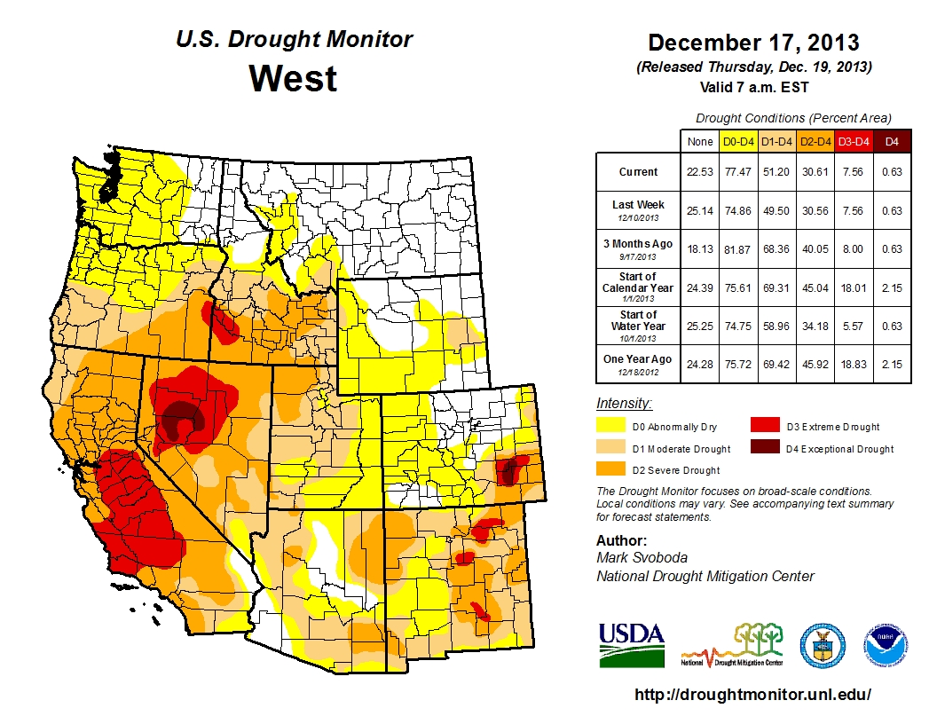
Current weather summary
A weak cut-off low pressure system brought some convective shower activity to parts of Southern California earlier this week, and a few locations received rather heavy (if brief) downpours. Unfortunately, overall precipitation was very insignificant for a late-December weather system in California and most places north of Santa Barbara saw no precipitation whatsoever. High pressure has since been rebuilding over the West Coast, with generally clear conditions and increasingly warm temperatures (approaching record levels in some places). With no meaningful precipitation expected through December 31st, calendar year 2013 will be the driest year on record in the state of California.
The extraordinary persistence of the Ridiculously Resilient Ridge of 2013
Zonal (west-to-east) flow typically predominates during the cool season in this region, which directs storm systems that develop over the ocean toward the West Coast. While the storm track does often vary in latitude along the West Coast over the course of any given winter, southward excursions of the jet stream usually bring periods of significant precipitation to much or all of California, which account for the vast majority of all precipitation observed in the state. 2013, however, has featured rather incredibly persistent atmospheric anomalies over the northeastern Pacific Ocean and the West Coast of North America. The typical zonal flow over the Pacific has been much weaker than average and displaced well to the north, occasionally as far north as continental Alaska. This means that the storm track has largely missed the West Coast entirely, bringing well-below-normal precipitation to California, Oregon, and Washington while parts of Alaska are subjected to record warmth and heavy precipitation.

The proximate cause of this highly anomalous high-latitude storm track over the Pacific–as I have discussed in previous posts–is the Ridiculously Resilient Ridge of 2013 (or the RRR, for brevity). This region of strong and incredibly persistent anomalous geopotential height ridging is centered over the Gulf of Alaska but extends across much of the northern and eastern Pacific Ocean, and has been a coherent and distinct feature of the large-scale atmospheric pattern for over a year (beginning in early December 2012). This persistent ridging has resulted in a flow pattern that has deflected existing Pacific storms well to the north of California and suppressed the development of other systems closer to the state. Persistent ridges that disrupt the prevailing westerly winds in the middle latitudes are often referred to as “blocking ridges” because of their propensity to impede and deflect typical atmospheric flow patterns, and the RRR is no exception.
Because this blocking ridge and its associated poleward (south-to-north) wind anomalies are centered well offshore, California has generally been in the equatorward (north-to-south) wind anomaly region and thus an unusual amount of our weather events over the past year have originated to our north or even northeast over western Canada. These dry and windy “inside slider” disturbances, so named for their over-land trajectory to the east of the more typical coastal route, have been responsible for the numerous offshore flow events that have contributed to record high winter fire danger in northern and central California.
Two tales of extreme dryness: 2013 vs. 1976-1977
One of the most vivid historical examples of drought in California is the two year dry period spanning 1976 and 1977. Precipitation during each of these calendar years, and during the 1976-1977 water year in particular, was extremely low–these were two consecutive years in which statewide precipitation was ranked among the top five lowest ever recorded in California. The 1976-1977 drought is notable for two reasons: the objective meteorological magnitude of the event in terms of the enormous precipitation deficit and also the enormous (and in many cases permanent) effect it had on human systems in California. The mid-70s drought garnered substantial media attention due to the regionally exceptional water shortages that it caused, with impacts ranging from the temporary cessation of agricultural activities in some parts of the Central Valley to the construction of an emergency water pipeline across the Richmond-San Rafael bridge in the Bay Area when local reservoirs ran almost completely dry. This drought event led to significant changes in water management practices in the state of California, including the development of more aggressive contingency plans for relatively short-term (1-2 year) periods with extremely low precipitation.
![]()
![]()
![]()
Above: Jan.-Nov. precipitation anomaly ranks; 1976 (left), 1977 (center), 2013 (right)
The present dry spell has been increasingly compared to the 76-77 drought. So, how exactly does 2013 stack up to the previous most extreme dry period in living memory? Precipitation-wise, the 76-77 event was characterized by two consecutive years with very low precipitation, while the present event consists of one modestly dry year (2012) and one record-dry year (2013). Notable is that 2013 is drier than any previous calendar year in the historical record by a wide margin (around ~20%).
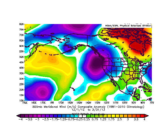
Next, consider the broader anomalies observed for several important atmospheric quantities. We already know about the incredible persistence of the RRR in 2013, and many readers may be familiar with the remarkable persistence of the observed patterns during the 1976-1977 drought as well. But a particularly amazing aspect of the present dry spell is that the 2013 large-scale anomalies are now clearly visible on a timescale greater than one year. This is highly unusual given that the typical variability of weather patterns is on timescales much shorter than one season, let alone one calendar year. Plots depicting the observed 1-year geopotential anomalies for 1976, 1977, and 2013 are featured below. (Note: all of the following figures are derived from the NCEP reanalysis using the excellent plotting tools on ESRL’s website. Also, values for 2013 are for the full year up until December 18th while 1976 and 1977 are full-year values.)
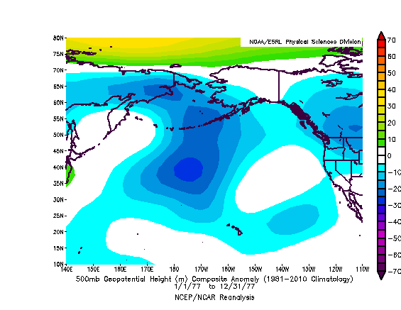
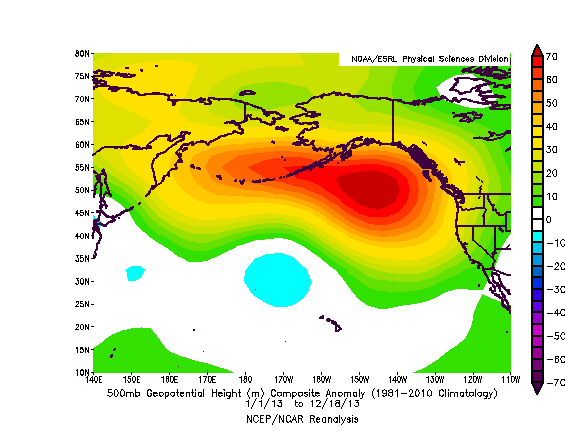
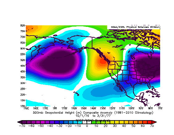
Interestingly, the year-long anomalies for the 1976-1977 drought appear to be quite different from the 2013 extreme dry period. In fact, there even appears to be some persistent troughing (low geopotential height anomalies) in the same region where very large positive anomalies have been present this year. But it’s also well known that the winters of 1975-76 and 1976-1977 did indeed feature periods of strong and highly-persistent ridging over the eastern Pacific that were associated with very dry conditions along the West Coast.
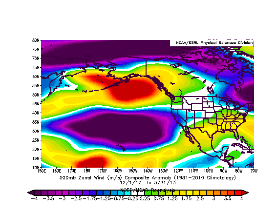
Taking a closer look at the observed conditions in winter 1976 and 1977 (December-March), a different pattern emerges–one that does exhibit persistent ridging along the West Coast but of a much lesser magnitude than the RRR of 2013 and centered further to the east. Also, the winter 76-77 pattern exhibits a more “wavelike” pattern in geopotential height anomalies than 2013–there are negative (troughing) anomalies in the West Pacific and also over eastern North America. But the zonal wind anomalies during the 75-76 and 76-77 winters are actually quite similar to those observed throughout calendar year 2013, suggesting that a large northward shift in the storm track was responsible for the extreme dry conditions in both instances despite the large qualitative difference in geopotential height patterns.
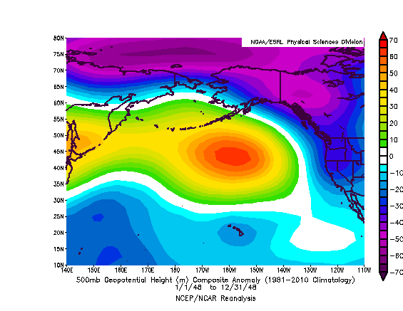
It appears, then, that the RRR observed in 2013 really is a pattern distinct from that observed during the 1976-1977 drought. Just how rare is this hyper-persistent ridging in the Gulf of Alaska, then? The NCEP reanalysis goes all the way back to 1948, with the caveat that interpretation of data predating the use of Earth-observation satellites in 1979 is subject to larger uncertainty, especially over the data-spare Pacific Ocean. After examining composites of annual geopotential height anomalies for each full calendar year since 1948 (link to large file here), I find several instances where persistent ridging or troughing lasting a year or longer is present in the Gulf of Alaska, but no instances that even come close to the intensity or spatial extent of the anomalous ridging present over the Gulf of Alaska during 2013.
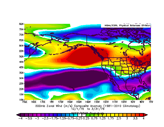
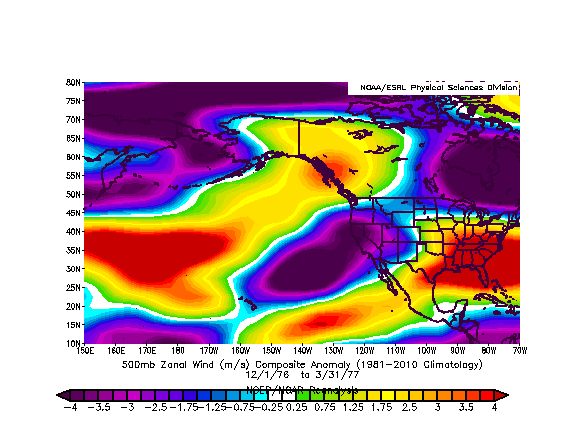

Above: zonal wind anomalies (1975-1976 (left), 1976-1977 (center), 2013 (right) )
The first year of the reanalysis (1948), interestingly enough, appears to be the most analogous to the recent observed pattern (data uncertainty caveats aside), but even in this case the 2013 anomaly is of considerably higher magnitude. Thus, the data suggest that the persistence of the RRR in 2013 may be unprecedented since at least 1948, and the observed pattern is actually rather different than that which was in place during the 1976-1977 drought.
Is there any hope for significant rain in California?
In the short term, the unfortunate answer is a pretty definitive “no.” The operational medium-range forecast models are pretty unanimous in projecting a continuation of the mean blocking ridge over the northeastern Pacific for the next 1-2 weeks, with high-amplitude flow anomalies continuing to bring exceptionally dry conditions to the West Coast and exceptionally cold conditions (in the downstream trough) over the American Midwest and Great Plains well into January.
With such an extraordinarily persistent blocking pattern seemingly entrenched over the Pacific, it will take a very significant change in the overall flow pattern to disrupt the current status quo, and such a change is just not on the horizon at the moment. With reservoir levels now starting to drop very rapidly and certain water districts calling for at least voluntary water rationing measures, the exceptional dry spell of 2013 appears likely to continue into at least the early part of 2014. Stay tuned.
© 2013 WEATHER WEST
A comparison of California’s extreme 2013 dry spell to the 1976-1977 drought Read More »