California dodges worst of historic Pacific Northwest heatwave, but long-duration heatwave still likely inland. Plus: significant monsoonal surge next week?
An *exceptionally* hot June across the American West
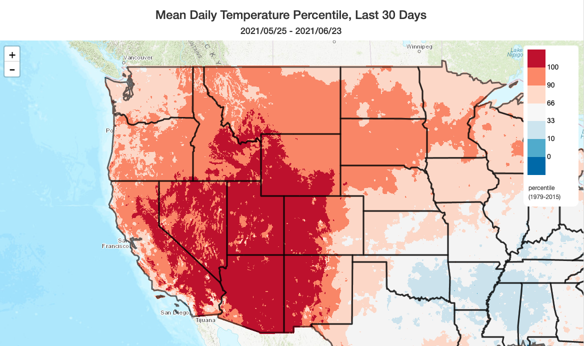
I won’t belabor the point here–it has been incredibly, record-breakingly hot (yet again) across almost the entire American West in recent weeks. The immediate coast in California has, conspicuously, not been nearly as anomalously hot–and has actually been near average in some spots thanks to cooler than average ocean temperatures and a robust marine layer. But that’s a different universe from the interior parts of CA and the rest of the west, which have just suffered through what is likely to become the hottest June on record in many areas. And even more exceptional heat is to come across the Northwest–more on that below.
Incredible & historic heatwave across Pacific Northwest and southwestern Canada
The most extreme heatwave I can ever recall having watched evolve in my lifetime over the continental U.S. is presently unfolding along the West Coast of North America, centered on the Pacific Northwest and southwestern Canada. This coming weekend, virtually every high temperature record in existence will be broken across an enormous swath of land extending from central BC to central Oregon. This will most likely become the singularly most intense heatwave in modern history for much of the region, featuring temperatures that will probably shatter all-time record high temperatures in many cities and towns and mid-atmospheric high pressure that will be stronger than any previously observed in the region. This is a heatwave that has left meteorological observers in awe, and even caused some of us to question the validity of these extreme model predictions. Well, confidence has now increased to the point that I’m pretty comfortable saying that the models did a great job with this historically unprecedented pattern (save for a slight northward shift, relative to initial predictions, that will largely spare CA the worst of things).
This heatwave will have extremely high societal impacts across the Pacific NW and SW Canada, and will pose a very serious public health threat in a region where structures are not designed to shed heat and where active home cooling (i.e., air conditioning) is uncommon. Heat of this incredible magnitude will not only lead to many heat-related illnesses, but could also disrupt both transportation and electricity-distribution infrastructure–as well as turbo-charging wildfire risk in the densely forested areas that characterize much of the region.
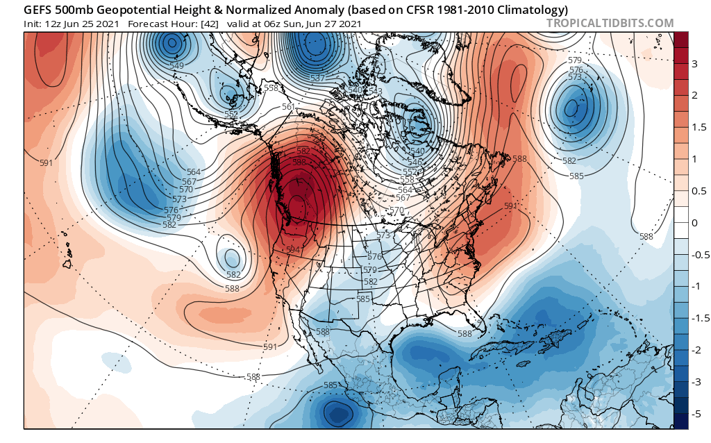
What’s causing this spectacular, yet quite dangerous, extreme weather event? A “Rex Block” is rapidly intensifying “in place” over southern British Columbia–completely disrupting the mean westerly flow across a broad region and causing mid and upper-level winds to flow almost due east-to-west across WA and OR. As the associated ridge strengthens, very strong subsidence (downward motion) in the atmosphere will develop–causing dramatic adiabatic warming of the airmass as it descends toward the surface and completely suppressing cloud cover. The combination of long-duration offshore flow aloft, very strong subsidence, and near-cloudless skies will produce an incredibly hot airmass throughout the atmospheric column. Once it’s in place, this blocking pattern will likely persist for quite some time–persistent ridges in summer can be very difficult to “dislodge” as they tend to re-organize the hemispheric flow pattern in a way that favors ridge persistence (a “positive feedback”/self-reinforcing cycle). And indeed: the models suggest only a very slow breaking down of this high pressure system heading into the first week of July. This means that even after the record-shattering temps moderate somewhat later next week, very hot conditions will likely persist for many days across the affected areas and greatly compounding impacts (especially if wildfire activity becomes elevated, as seems likely).
Finally, and as many climate scientists have already pointed out, global warming is greatly increasing the odds of experiencing unprecedented heat extremes–both here in the Western U.S. and elsewhere around the world.
California will dodge worst of extreme PacNW heatwave, but interior areas will see prolonged period of very hot conditions
Northern California finally caught a break, of sorts–it no longer appears that the astonishing, all-time record shattering heat across the Pacific Northwest will extend across the Golden State. Given the state of the already extreme drought and the precarity of the wildfire situation, that is exceedingly fortunate.
But it is worth considering what might have been, since this was an exceptional weather event just narrowly averted. Some parts of Washington, Oregon, and British Columbia may break their all-time records by a margin of 5 or more degrees F–a truly astonishing margin in climatological terms. For perspective, in California, breaking all-time records by 5+ degrees would mean temperatures at or above 123F in Redding, 119 in Sacramento, 120 in Fresno, 111 in downtown San Francisco, 118 in downtown Los Angeles, 128 in Palm Springs, and even 104 in South Lake Tahoe. Had this extreme and historic ridge set up shop just a couple hundred miles south, some of these numbers could have been realized this weekend or next week.
But this time, at least, CA got lucky. Phew.
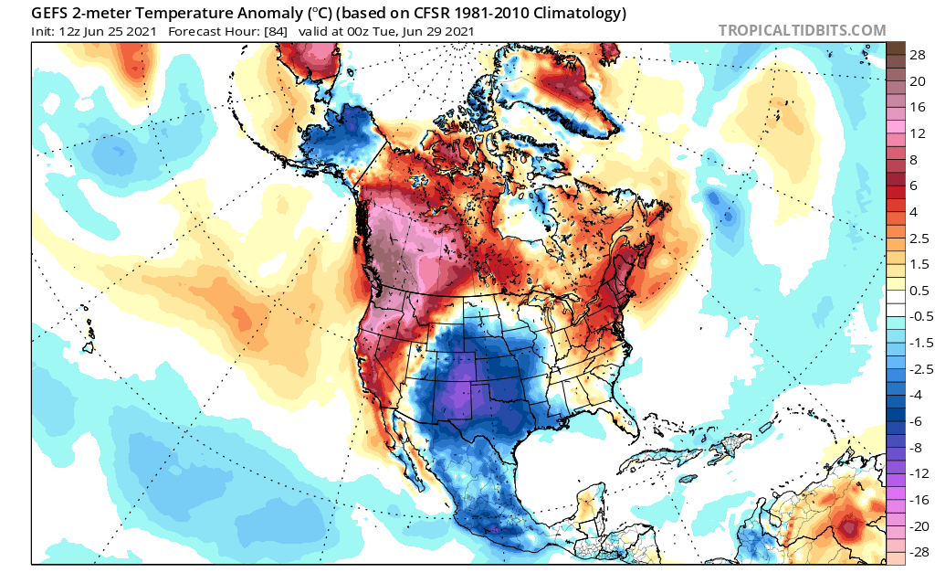
That said, a very prolonged period of fairly intense heat will still occur across most of the CA interior beginning this weekend and perhaps continuing all the way toward the 4th of July in some areas. Coastal areas will very likely be spared, and the heat will not be remarkable there. But over the Central Valley and SoCal inland valleys/deserts, where Excessive Heat Watches are once again in effect, a prolonged period of 100+ temperatures is highly likely. Daily records may still fall, especially across the northern Sacramento Valley and northern mountains closest to the record ridge (Redding and surrounding areas could still see at least a couple of days of 110+, but probably not 115+). This will round out what has already been a record-hot month across some inland portions of California–and will continue to dry out vegetation that is already running about two months ahead of typical dryness values for June.
Significant monsoonal surge could bring some summer showers/thunderstorms to CA next week–even outside of mtns/deserts
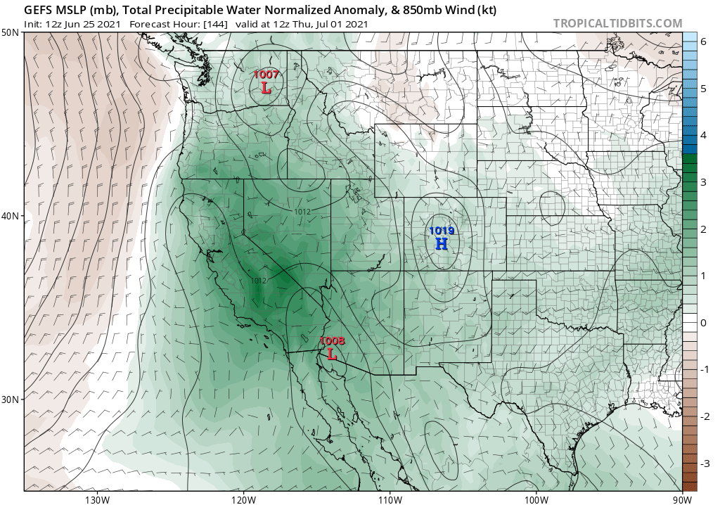
In this midst of ongoing heat across the Northwest, a rather robust monsoonal surge of moisture may take shape–moving northwestward across California by the middle of next week. The GFS, in particular, is suggesting the potential for both a pretty robust increase in humidity throughout the atmospheric column along with at least one significant easterly wave. That easterly wave, if it actually materializes, has the potential to generate some convective activity even outside of the usual mountain and desert regions and perhaps across coastal/valley areas. Right now, the odds of this happening will be highest across SoCal, but there may ultimately be a risk of more widespread convective activity across NorCal as well heading toward the 4th of July weekend. Details with monsoonal surges are always hard to parse more than a day or two in advance, but this one has the signs of a potentially significant one for portions of CA.
This evolution could be a bit of a mixed blessing. On one hand, it will likely bring some “interesting” skies to weather watchers statewide, and could also bring some needed precipitation across the mountains and parts of SoCal. On the other hand, this surge will likely increase surface humidities at a time when conditions are already hot inland–making things locally muggy and uncomfortable. And perhaps more significantly, there will be the potential for fairly widespread lightning across much of CA next week. Many of these storms will actually be associated with precipitation and even some locally heavy downpours–but in June/July, there’s always a risk of dry lightning strikes and given the extreme level of vegetation dryness right now–even fairly wet thunderstorms could yield “holdover” lightning fires that smolder for a while then take off later when conditions warm up and dry out. So the potential for wildfire ignitions could once again be elevated later next week, depending on exactly how things develop.
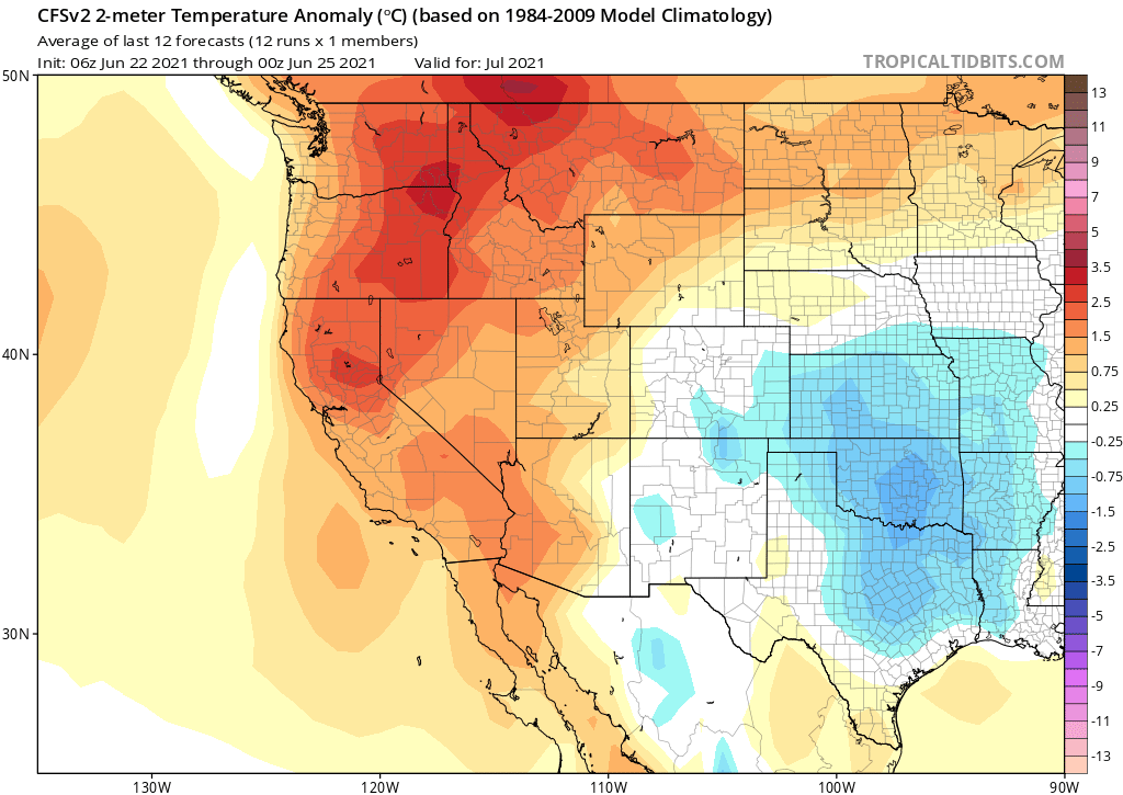
Hotter-than-usual summer conditions to continue into July, but monsoon looks better than last year
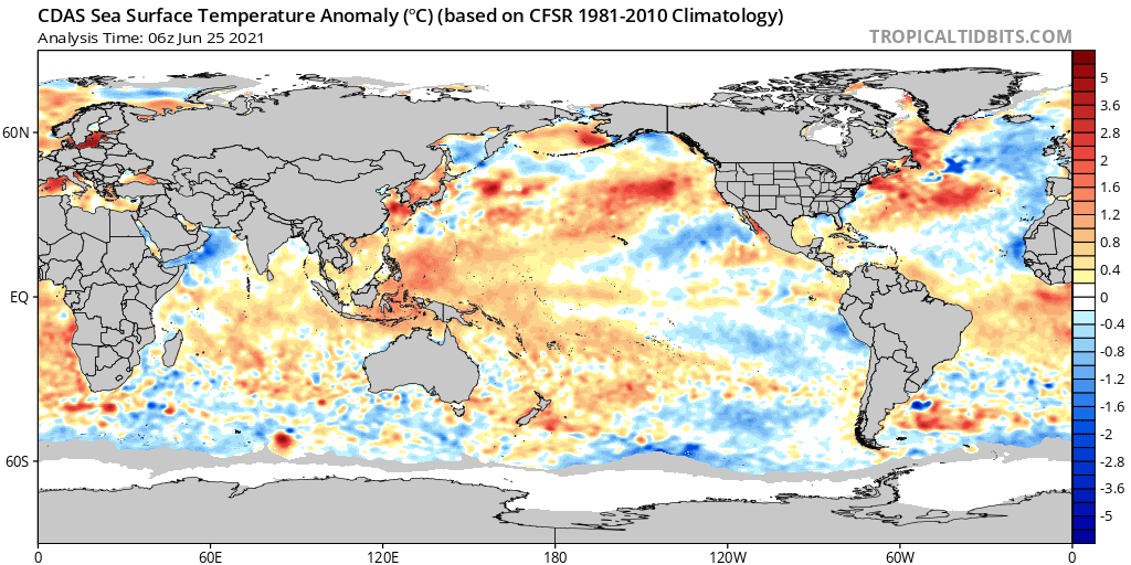
The rest of the summer, and particularly July, look…well, hotter than average. Again. In fact, the July pattern in the GFS looks a lot like the June pattern we’re just wrapping up–with lots of excess heat along the Pacific Coast states in particular. Coastal areas may start to see more anomalous warmth, as well, as ocean temperatures have recently done a 180 and are now significantly *warmer* than average along the CA coast (and may warm yet further this week as strong high pressure takes hold along the coast).
A possible silver lining, though, is that the models also suggest that the monsoon this year is likely to be much better than last year. The short term forecast certainly supports this, as do multi-month outlooks from the seasonal models. This is especially relevant across the interior Southwest, but may also extend to portions of southern and eastern California (as it likely will next week). Fingers crossed! In the meantime, stay cool if you’re in an inland area…and if you have family or friends in the Pacific Northwest, reach out to them now to let them know that this upcoming heatwave will almost certainly be the worst of their lifetime in the region–and to prepare accordingly.