Renewed Arctic outbreak across American West; possible low elevation snow in California
Season-to-date assessment: drought relief across much of CA, but more needed
As we near the end of 2016, just how has California fared over the past several months in the midst of a deeply entrenched, multi-year drought? The answer: pretty well, especially in the Northern Sierra. Season-to-date precipitation as of late December remains well above average in far northern reaches of the state–including many of the watersheds that contribute the lion’s share of California’s water supply. Further south, conditions have not been nearly as wet. The Bay Area has seen slightly above average precipitation, and much of Southern California is still below average to date (although recent and unexpectedly significant precipitation courtesy of a cutoff low have bolstered totals near Los Angeles and San Diego).
Despite abundant #Sierra precip, warmer than avg temperatures have led to well below avg #snowpack to date, esp. at lower elevations. #CAwx pic.twitter.com/ungfcraDeD
— Dr. Daniel Swain (@Weather_West) December 27, 2016
Temperatures have so far not been quite as warm as in recent winters, although in most spots they have still been well above the long-term average. In fact, despite abundant precipitation in the northern Sierra Nevada, snow water equivalent throughout California is running considerably behind typical late December values due to these relatively warm mountain conditions. This has been especially true on the lower slopes, which are generally closer to the freezing line and are more sensitive to smaller variations in temperature.
All in all, the season-to-date perspective is one that paints a fairly optimistic picture from a short-term drought alleviation perspective. In the longer term, lingering multi-year precipitation deficits (especially in the south) and the ongoing statewide “snow drought” mean that drought conditions will still persist throughout much of California through the rest of the rainy season–although with reduced severity relative to peak conditions a couple of years ago.
Arctic blocking ridge precipitates Western U.S. Arctic outbreak
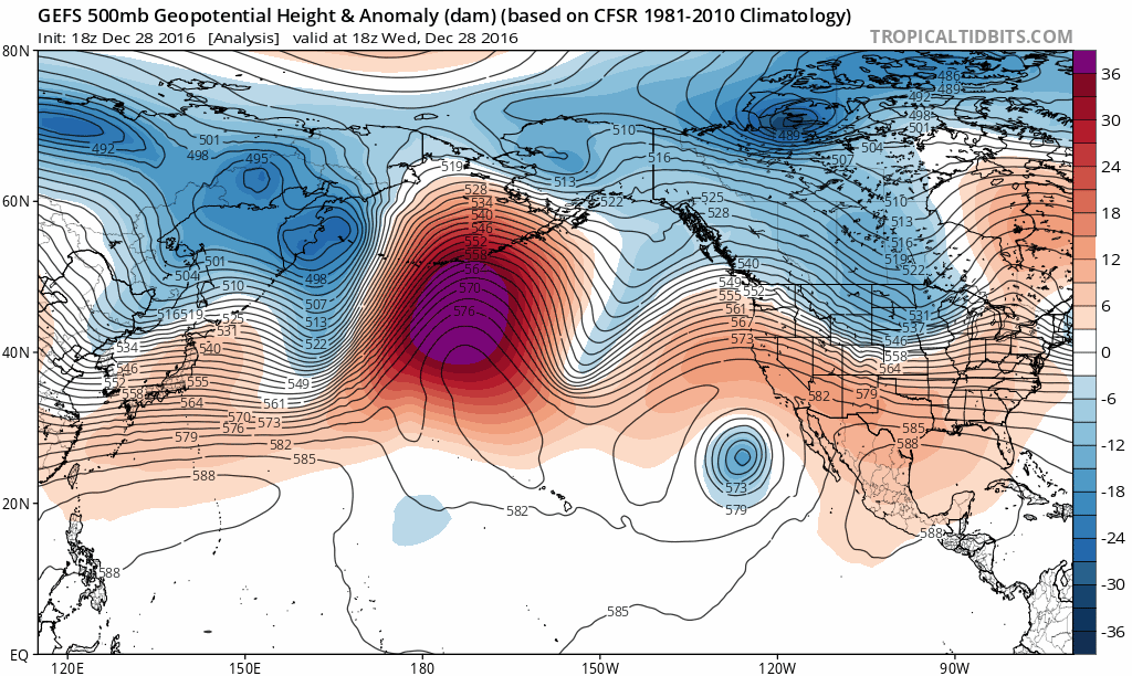
The overall North Pacific circulation pattern over the next 1-2 weeks is highly similar to the one discussed in the last blog update in early December. Very strong high pressure both at the surface and aloft near Alaska will develop quasi-stationary “blocking” characteristics–anchoring itself at roughly the same position for an extended (>10 day) period and inducing highly anomalous wind patterns downstream over North America. Specifically, this Alaskan blocking ridge will cause the jet stream to dive southward on its eastern flank–which in this case will be right along the coast of western North American. Very cold (and relatively dry) Arctic air will become entrained in this strongly “meridional” north-south flow over the American West, bringing another outbreak of bitterly cold conditions to much of North America.
Interesting, the extremely warm Arctic temperatures and record-low sea ice conditions mentioned in the last update have persisted–and once again appear to be linked to the extreme atmospheric blocking episode near Alaska. This so called “Warm Arctic/Cold Continents” pattern has been prominent during a number of recent winters, but has been especially noticeable over the past couple of months as unprecedented warmth has pervaded high Arctic despite the onset of polar night.
Early hints of possible low elevation snow in California
This large-scale atmospheric setup is a near-ideal setup for bringing very cold conditions and lowland snowfall to the Pacific Northwest, even in areas that don’t often see snow near sea level. It’s also reminiscent of the atmospheric circulation regimes that have historically produced Arctic outbreaks and very low elevation snowfall across parts of California in past decades. This sort of pattern, once again, has high “boom or bust” potential–and could ultimately be characterized by 1) rather cold but otherwise inactive weather or 2) very cold but also rather active weather, with frequent bouts of showers with low snow levels. Right now, it appears there will be a pretty good chance of seeing at least 1-2 “low snow” events in NorCal over the next 10 days, and possibly further south as well.
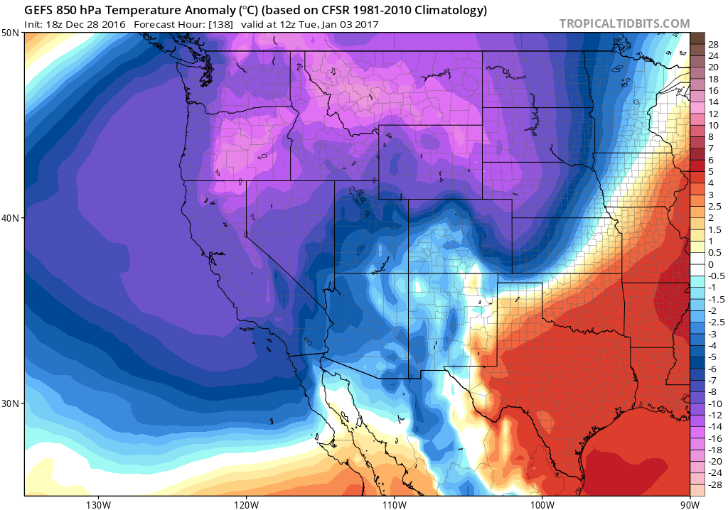
While it’s tough to be specific about prospects for low elevation snowfall in specific regions, it does appear that the potential exists for a prolonged, deep freeze across much of California along with the possibility of some accumulating white stuff in unusual places. Both the ECMWF and GFS ensembles suggest that atmospheric “thicknesses”–a measure of the average temperature of the entire air column above one’s head–will approach levels rarely seen in California (perhaps below 525dm in the 1000-500mb layer). This will most likely bring the possibility of accumulating snow below 1000 feet in elevation in NorCal, and perhaps even close to sea level at some point (especially along the North Coast and across parts of the Sacramento Valley). There are a lot of things that need to come together just right to see snow near sea level anywhere in California, but this is likely to be one of those rare patterns where it may be possible.
Meanwhile, higher mountain areas (including the Sierra Nevada) will likely see quite a bit of light, powdery, low water content snow over the next 10 days or so (great for skiing; not as helpful for California’s water supply). This will be quite the change from recent winters in which significant middle-elevation snow accumulations have been few and far between.
Bigger storms possible out beyond day 10 as cold pattern breaks
Eventually, the blocking ridge over Alaska will break down and the Arctic outbreak over western North America will dissipate. When that happens, the jet stream will likely “undercut” the persistent North Pacific block and deliver a bout of very active weather to the West Coast. At the moment, there is some indication this may happen in the 10-12 day period. But given the complexity of the pattern expected to evolve over the coming week, it’s still too early to discuss the details.
I’ll most likely have another blog update soon if a low elevation snow event appears imminent in California; until then, feel free to follow the Weather West “micro” updates on Twitter.
Renewed Arctic outbreak across American West; possible low elevation snow in California Read More »