Recent record warmth to be interrupted by Wednesday storm; long term prospects mixed
Remarkable stretch of mid-winter warmth, especially in Southern California
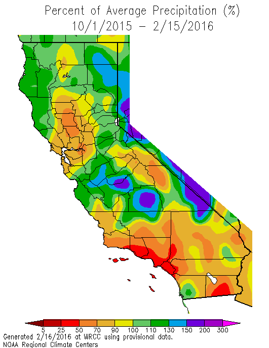
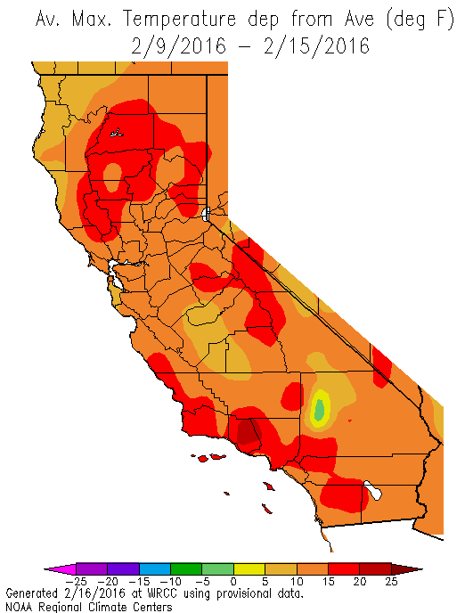
February has thus far felt a lot more like July across a wide swath of California. Almost no precipitation of significance has fallen in California since the start of the calendar month, and record high temperatures have been set nearly every day in at least a few locations. The heat in Southern California has been truly sweltering: recent daily maximum temperatures exceeding 90F in the Los Angeles area have actually exceeded average summer temperatures on multiple occasions. Even in the Bay Area and Central Valley, temperatures have reached 80 degrees during the height of winter.
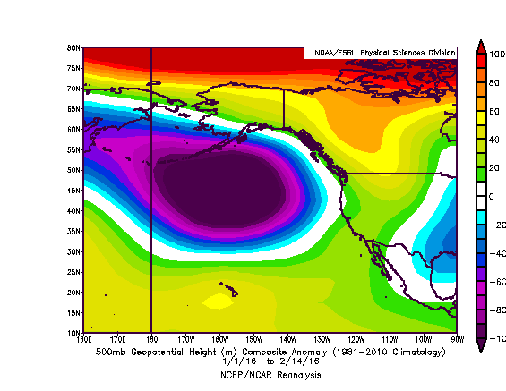
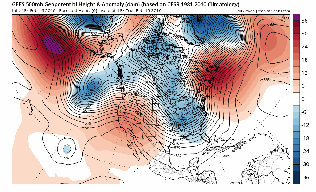
The proximal cause of this record warmth and widespread mid-winter dry spell is (perhaps unsurprisingly) the development of a strong high pressure system roughly aligned with the West Coast of North America. This setup is a bit different than that which brought dry weather to Southern California but wet conditions to Northern California earlier this winter–since the more recent one has essentially re-directed the jet stream (and subsequently the storm track) well to the north of the state. This pattern may sound familiar to regular readers: it’s similar to the setup brought about by the Ridiculously Resilient Ridge, which set up shop over the far northeastern Pacific during recent California drought years and continued for many months at a stretch. One critically important difference is that this ridge has not yet been nearly as “resilient” as those during recent winters. Mid-winter dry spells lasting multiple weeks are not at all uncommon in California–in fact, they are arguably a characteristic feature of our “feast or famine” rainy season. So we still have a way to go before it would be reasonable to start talking about the return of the Triple R. That said, strong West Coast ridging during what is statistically one of California’s wettest months is not really what drought-weary Californians want to see, and also not quite what we might have expected during what remains one of the largest El Niño events on record in the Pacific basin.
Sudden, but brief, shift to wet and cooler conditions on Wednesday
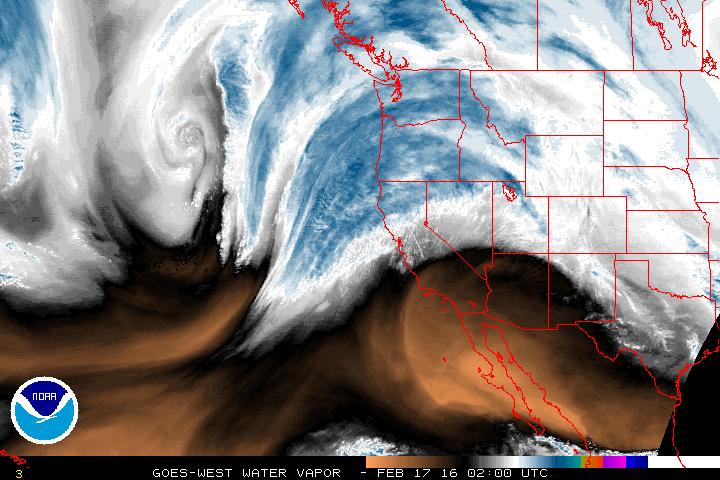
A much-needed respite from recent record warmth and notable dryness will occur on Wednesday, as a fairly robust Pacific system temporarily punches through the strong West Coast ridge. This system has a pretty significant connection to subtropical and even deep tropical moisture due to some unusually extensive convection over the eastern tropical Pacific Ocean in recent days. But while tomorrow’s system has plenty of moisture to work with, large-scale dynamics will be more modest–and this system will not be especially intense overall. Still, it will bring an abrupt and very noticeable change in the pattern to the entire state. Much cooler temperatures and widespread precipitation, along with gusty winds, possible thunderstorms, and substantial mountain snowfall, are all expected.
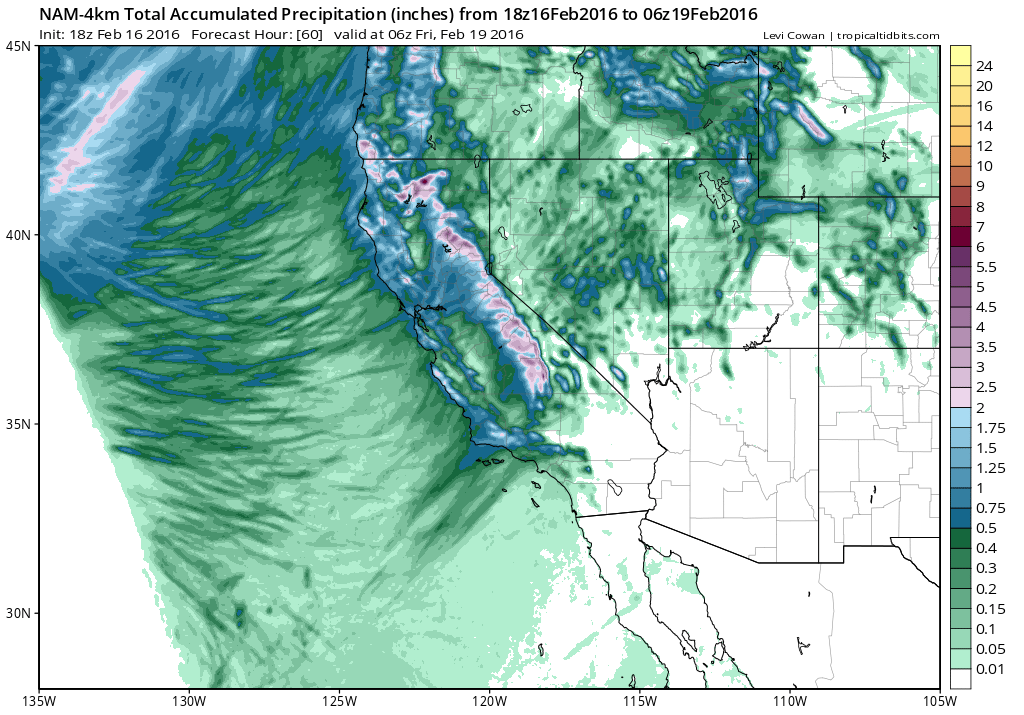
There will be a modest atmospheric river associated with this incoming storm system, and there could be some decent orographic enhancement of precipitation (especially in Southern California). Lower elevations should still see measurable precipitation virtually everywhere, and parts of NorCal could see a decent soaking (as much as 1-2 inches of liquid, and 1-2 feet of high-mountain snowfall). Also, there may be some potential for this system to “outperform” current model precipitation forecasts given the presence of a decent subtropical moisture tap. All in all, this system will be enough to water the plants, freshen the ski slopes, and clear the air, but it won’t accomplish much in the way of drought relief.
Return to ridging in the medium term, but signs of more active pattern by end of February
There’s presently pretty good model ensemble agreement that warm and dry conditions will quickly return to all of California by the coming weekend following Wednesday’s precipitation, and persist for at least a week (although temperatures will probably not be as warm as recent record-breaking values). Looking out even further than that, though, there are still tantalizing signs of a potential shift to much wetter conditions by the very end of the month. The GFS and ECMWF ensembles have both been suggesting that the anomalously deep Gulf of Alaska low which has been present so far this winter will shift subtly eastward over the coming 2 weeks, eventually displacing the West Coast ridge far enough to the east to allow the “storm parade” which has been present across the North Pacific for the entire winter to reach California. There has also been a consistent wet signal in CFS seasonal forecasts for March, which would be in agreement with more recent GFS/ECMWF model trends. Therefore, I’d still say there’s a good chance that most or all of California will experience above-average precipitation going into March (although with each passing dry week it’s getting decidedly harder to make up the accumulated seasonal deficits in Southern California). Despite some recent claims to the contrary, there is still time for substantial drought relief this winter in California…but the clock is ticking.
More thoughts on the bigger picture
Finally, it’s worth noting that seasonal forecasts have consistently underestimated the magnitude of subtropical ridging over and southwest of California so far this winter. Despite the occurrence of one of the most powerful El Niño events on record, Southern California has remained very dry this winter (and Northern California, while wet until recently, is now starting to fall behind). As I discussed extensively in my previous post, there are some relatively subtle but critically important differences between the atmospheric response to the 2015-2016 El Niño and to other large 20th century ENSO events. 2015 was the warmest year on record globally by a huge margin, and the early part of 2016 has brought warmth that is arguably even more dramatic (particularly in the Arctic, where sea ice is currently at its record low extent for this time of year).
Warmth in Jan. 2016 was esp. felt in higher latitudes, incl. Arctic, as chart shows https://t.co/4v9ub0BVSN pic.twitter.com/7H5zgNc48G
— Andrew Freedman (@afreedma) February 17, 2016
I’ll reiterate that it’s impossible to discern in real time–and especially within the confines of a blog post–exactly why California has been considerably drier than expectations during the present very strong El Niño event, and why West Coast ridging has been so prominent during recent winters. One thing that is clear is that warming temperatures have already increased the likelihood and severity of drought in California–irrespective of changes in precipitation patterns. While a strong finish to the 2016 rainy season would bring substantial and meaningful drought relief, the legacy of California’s extraordinary multi-year drought will almost certainly persist through the coming summer (which, indeed, echoes a familiar refrain from earlier in the autumn). I’ll have much more to say on these subjects later this summer, and plan to have a series of blog posts devoted exclusively to that conversation. Stay tuned.
© 2016 WEATHER WEST
Recent record warmth to be interrupted by Wednesday storm; long term prospects mixed Read More »