Update on the North American Monsoon and active California summer weather
Quick summary of recent conditions
An active monsoonal pattern over the past 1-2 weeks has brought some active summer weather to California’s mountain and desert regions. Strong (to even severe)
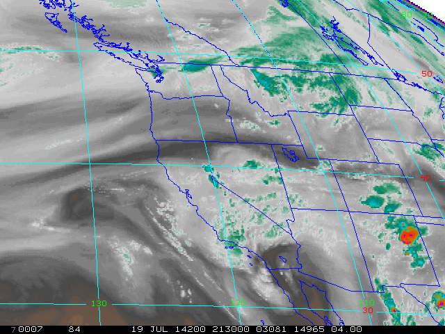
thunderstorms have occurred nearly daily over parts of the California interior, bringing locally intense downpours and resulting in some minor flash flooding in a few highly localized areas. Thousands of lightning strikes have occurred over California’s tinder dry forested regions over the past week, though most of these strikes have been accompanied by considerable rainfall. This is in stark contrast to the current situation in Oregon and Washington, where dry lightning strikes have led to massive and destructive wildfires over the past week.
Why are there thunderstorms in California in July?
The primary reason for all of this active weather throughout the West in recent days is the seasonal reversal of large-scale wind patterns associated with the North American Monsoon. This reversal occurs every summer, and is typically associated with occasional convective activity (often in the form of thunderstorms) over mountain and interior regions of the Southwest. Occasionally, this pattern can expand northward and westward to include California in the region of deep southeasterly flow around the characteristic mid-atmospheric high pressure area centered near the Four Corners region. Due to the stabilizing influence of the cool Pacific Ocean near the coast of California, convective activity associated with the monsoon is typically confined to mountain and desert regions, and thus tends to stay away from California’s major population centers. This gives rise to the perception that it never rains in California during the summer months (which is, indeed, a rather accurate characterization if one lives in the coastal metro regions or in the Central Valley).
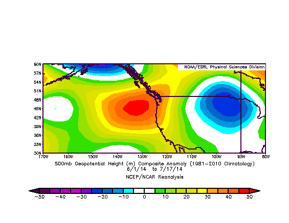
The current large-scale pattern is a bit different than usual, though. A region of anomalously strong and persistent high pressure in the middle atmosphere–which in recent weeks has once again become increasingly reminiscent of the much-maligned Ridiculously Resilient Ridge–has become prominent near the West Coast of North America. This ridge is part of an even broader region of highly-amplified atmospheric flow on the continental scale–a pattern that has led to some remarkable weather conditions across much of the United States. In recent days, record heat, thunderstorms, and extreme fire weather conditions have occurred in the Pacific Northwest while drastically cooler than normal temperatures have occurred throughout the eastern half of the United States. Part of the reason for this recent amplification may be an injection of energy into the Westerlies by a series of powerful “super typhoons” over the West Pacific Ocean.
This persistent ridge near the West Coast has allowed southeasterly flow to remain in place for an extended period of time, with a quasi-stationary cutoff low southwest of California remaining in place for similar reasons. The net effect of these persistent flow patterns has been to allow for the continuous advection of moist air into California over the past two weeks, which has led to the recurring mountain thunderstorm activity and rather humid/muggy conditions that have been experienced elsewhere.
Widespread high-based convective activity possible this weekend
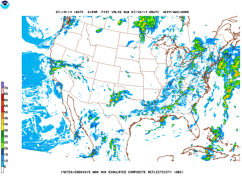
After several bursts of very weak high-based convection over valley and coastal regions in recent days (most of which did not result in any lightning), there finally appears to be a substantial risk of high-based thunderstorms tonight into Sunday across much of California.
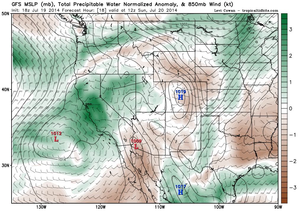
A weak disturbance will rotate around the east side of the offshore cutoff low this evening, which will likely be sufficient to trigger a band of elevated showers and possible thunderstorms. Recent high-resolution model forecast show that this band will lift northwestward across most of Northern California in the overnight hours and during the first half of Sunday, bringing scattered showers and very possibly scattered thunderstorms to a broad swath of California (likely including the Bay Area and Sacramento region). While the atmospheric column is actually quite moist and mountain thunderstorms could bring torrential downpours, storms elsewhere are still likely to be high-based and so any lightning will have the potential to start wildfires despite probable co-occurrence of some light showers. As of this writing, a few high-based cells with cloud-to-ground strikes had already developed in the San Joaquin Valley. These sorts of nocturnal warm-season convective events in California are notoriously difficult to forecast, and so uncertainty remains high even at this late hour. It’s entirely possible that lightning will not occur in coastal/valley locations tonight, but given the extreme wildfire risk in place across all of California due to the drought, it’s prudent to keep a close eye to the sky this weekend.
Medium-range outlook
The offshore cut-off low will finally eject to the northeast by Monday as a more zonal pattern develops along the West Coast. This will cut off the supply of monsoonal moisture to California, bringing about drier and cooler conditions for much of next week. However, long range model predictions are strongly suggesting that the Sonoran high will strongly rebuild by next weekend, bringing hot conditions and probably a return of monsoonal moisture, at least over the mountain and desert regions.
Special note: I’ll have an additional Weather West post late tomorrow on the ongoing and exceptional California drought and its consequences. Tune back in tomorrow for this extensive update!
© 2014 WEATHER WEST
Update on the North American Monsoon and active California summer weather Read More »