Record heat, unprecedented lightning fire siege in Northern California; more dry lightning to come
Record heat, historic NorCal lightning event lead to astonishing wildfire siege
Over the past 10 days, a record-breaking heatwave has affected virtually all of California, and a wide swath of the American West. Countless daily record maximum and overnight record minimum temperatures were set across the state on many consecutive days. In fact, Death Valley reached 130 degrees during this event–the hottest reliably measured temperature in world history. In addition to extreme temperatures, this heatwave was characterized by highly anomalous humidity levels–this was certainly not, as is often said in California “a dry heat.” For the first time in 19 years, rolling blackouts occurred throughout the state due to extreme strain on the power grid.
It was “Fogust” no more.
Then, mid-way through this extreme heat event, remnant moisture and instability from former Tropical Storm Elida combined with a robust easterly wave over California to generate one of the most intense summer thunderstorm events of the past 20 years across the San Francisco Bay Area. Most of the coastal portion of the Bay Area experienced intense–and even locally violent wind gusts during this thunderstorm event. Many places saw 40-50 mph gusts, but there were a few places that logged winds of 65-75 mph as these powerful storms moved ashore. Much of the SF Bay Area was under a multi-hour Severe Thunderstorm Warning by the NWS for the first time I can remember. Multiple places also experienced Midwest-style convective “heat bursts”–in which rapid collapse of thunderstorm updrafts caused air parcels aloft to plunge to the surface and warm to extreme levels. (Travis Air Force Base, for example, dramatically rose from 80F to 100F just before sunrise amid lightning and strong winds.)
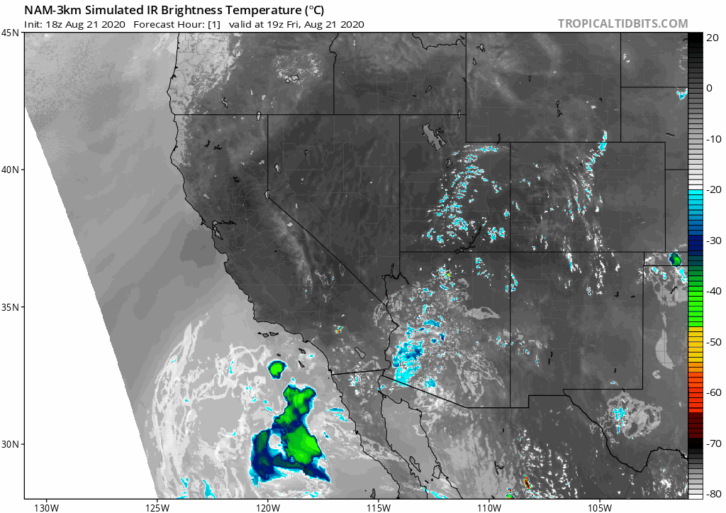
And there there came the lightning. Over 11,000 strikes were recorded over northern California over a 36 hour period, and many of these occurred pretty close to the coast (though some did extend inland over the Sacramento Valley and its foothills). As feared, unusually dry vegetation following an extremely dry winter and in the midst of a record heatwave acted as tinder–and many of these lightning strikes ignited wildfires. Over 350 lightning fires were reported over NorCal this week. But the number of fires is actually not the most problematic aspect of this event–it’s the astonishing speed with which these fires grew and their relative proximity to many heavily populated areas.
Size and scope of NorCal fires is historically unprecedented
As I’ve stated publicly, I’m essentially at a loss for words to describe the scope of the lightning-sparked fire outbreak that has rapidly evolved in northern California–even in the context of the extraordinary fires of recent years. It’s truly astonishing. By the time this post is published, around 800,000 acres of land will have burned over the past 8 days in California–over 700,000 of which in the northern part of the state, and about 500,000 within 100 miles of San Francisco. For perspective: less than 250,000 acres burned in California in all of 2019. There are so many fires right now that multiple wildfires under 5,000 acres have gone largely unattended, and unmentioned in the media. CalFire stated earlier today that to fight these fires to the maximum of their ability, the agency would near nearly 10 times more firefighting resources than are available.
Two individual fire complexes–the LNU and SCU Lightning Complexes–will each have burned around a quarter million acres by tonight or tomorrow (both are currently above well above 200,000 acres). Most of the fires within each complex have already merged together, or will shortly. Both of these fires complexes are *already* among the top 10 largest California fires on record, are still spreading, and have little containment. I’ve heard from fire folks that the SCU Complex could eventually become the largest fire on record in California–an incredible statistic, since the previous record was set in 2018 (and, before that, all the way back in 2017). Meanwhile, the CZU Complex in the Santa Cruz Mountains, while “smaller” at 50,000 acres, is burning through dense forest (including coast redwoods) that have very little modern fire history, and is threatening numerous smaller communities as well as the University of California, Santa Cruz (which has evacuated what limited students were currently on campus due to the COVID19 pandemic).
Smoke from these fires has inundated every corner of California. (Though the severity of the smokestorm varies–in some places, it’s a nuisance; in others, going outside has become acutely hazardous). Some places have been reporting measurable ashfall and large burned debris (leaves and twigs) raining from the sky. Extensive smoke from these California fires have blanketed much of the continental United States–resulting in a globally significant wildfire carbon emission event. This is not the best of news, to say the least, in the midst of an ongoing respiratory pandemic.
*Another* widespread NorCal dry lightning event possible Sun-Tues
I wish I had better news. I really do. This post is actually hard to write, especially knowing how much wildfire-related trauma many folks who read this blog have endured. Some comments section regulars have lost their homes in recent days; many more are currently evacuated, and are waiting for news. But at the moment, the weather forecast for the next few days is once again rather ominous from a wildfire risk perspective.
Beginning tomorrow, remnant moisture and atmospheric instability from former East Pacific Hurricane Genevieve will become entrained in deep southerly flow over and west of California. The first hints of the moisture will arrive in southern California, where widespread (wet) mountain and desert thunderstorms are likely. There is enough moisture that a few isolated storms could even occur over coastal parts of SoCal on Saturday, though I don’t currently foresee a widespread event down south.
Very unfortunately, however, farther north will be a very different story. Beginning later Saturday, a continued surge of moisture will make it as far north as the Central Coast and Bay Area. This initial surge will mainly contain mid and upper-level clouds, perhaps with some altocumulus mixed in. There is a very slight chance of a dry thunderstorm with this initial surge, but this will not be the main event and the initial surge may not contain any lightning.
Later Sunday into Monday, however, a deeper surge of mid-level moisture and instability will surge into central California from the south–coinciding with the approach of a weak remnant center of circulation from the old hurricane. This combination will likely be sufficient to trigger more widespread elevation convection from about San Luis Obispo northward, likely including (once again) the San Francisco/Monterey Bay areas, the Central Valley, and the western/eastern foothills of both the Sierra Nevada and the coastal mountains (and perhaps even elsewhere, but that remains uncertain). These storms will likely be dry, producing little to no rain with the possibility of many lightning strikes, due to a very dry sub-cloud layer over NorCal. This kind of atmospheric vertical profile is also favorable for the development of locally strong and gusty winds.
While I think, at this time, that it’s *unlikely* that this event will be quite as intense as last weekend’s, it does bear some similarity. I do expect substantially more than just isolated dry thunderstorms–overall lightning coverage may be scattered to widespread, with only isolated/brief showers. This (mostly) dry lightning, if it occurs, will likely ignite new fires at a time when available firefighting resources are extremely limited. Very gusty downdraft winds are also possible–which could be very dangerous near existing fires and cause locally extreme fire behavior and sudden flare-ups in any direction. For this reason, the National Weather Service has issued a Fire Weather Watch for much of northern California.
The most likely timing for this possible dry lightning event will be later Sunday through perhaps early Tuesday. Right now, the models are suggesting a pretty favorable pattern for this event to transpire–but I’d still say there’s about a 1 in 3 chance this falls apart and very little or nothing happens. Numerical models still struggle greatly with these kinds of elevated convection set-ups involving tropical moisture, since the atmospheric triggering mechanisms to release latent mid-level instability are often subtle and poorly-resolved. Moisture, too, is usually quite marginal–as will be the case this weekend. Therefore, I’m going to keep my fingers crossed that this ~30% chance that current forecasts are wrong, and that we don’t have another widespread dry lightning outbreak, comes to pass. That would be a welcome outcome, given the circumstances.
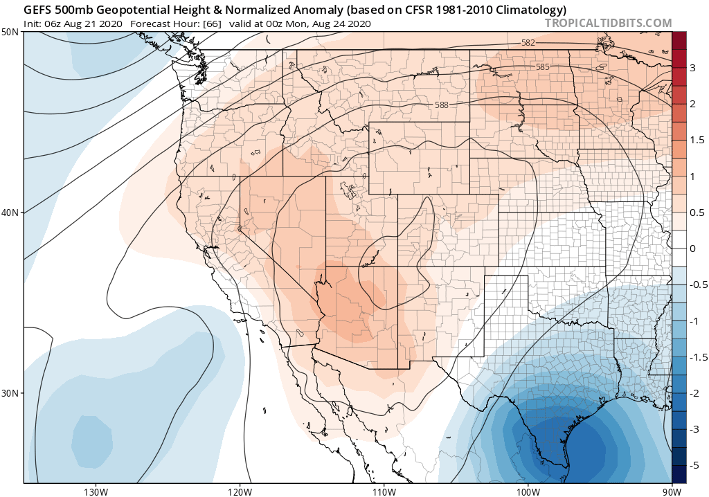
Meanwhile, as all of this is happening, the southwestern ridge will once again start to build back into California. The only bit of good news I have to offer is that it now appears this ridge will not build as strongly as had been previously foreseen last week, so while we will see another significant warming/drying/marine layer suppression trend next week it will pale in comparison to what California just experienced. Still, this does suggest that current conditions–with a shallow marine layer, and some coastal fog, and cooler temperatures–are about as favorable as they are going to get for a while from a firefighting perspective as things will go downhill again later this weekend into next week. I don’t really have any time to consider the long range very much, except to say I don’t see any obvious signs of major heatwaves during the first few days of Sept.
Stay safe out there. I’ll continue to follow these fires and renewed dry lightning potential both here in the Weather West comments section and on Twitter.