Mild spring pattern to continue across California through early May. Plus, thoughts on summer to come…
Mild spring conditions will continue for the next couple of weeks
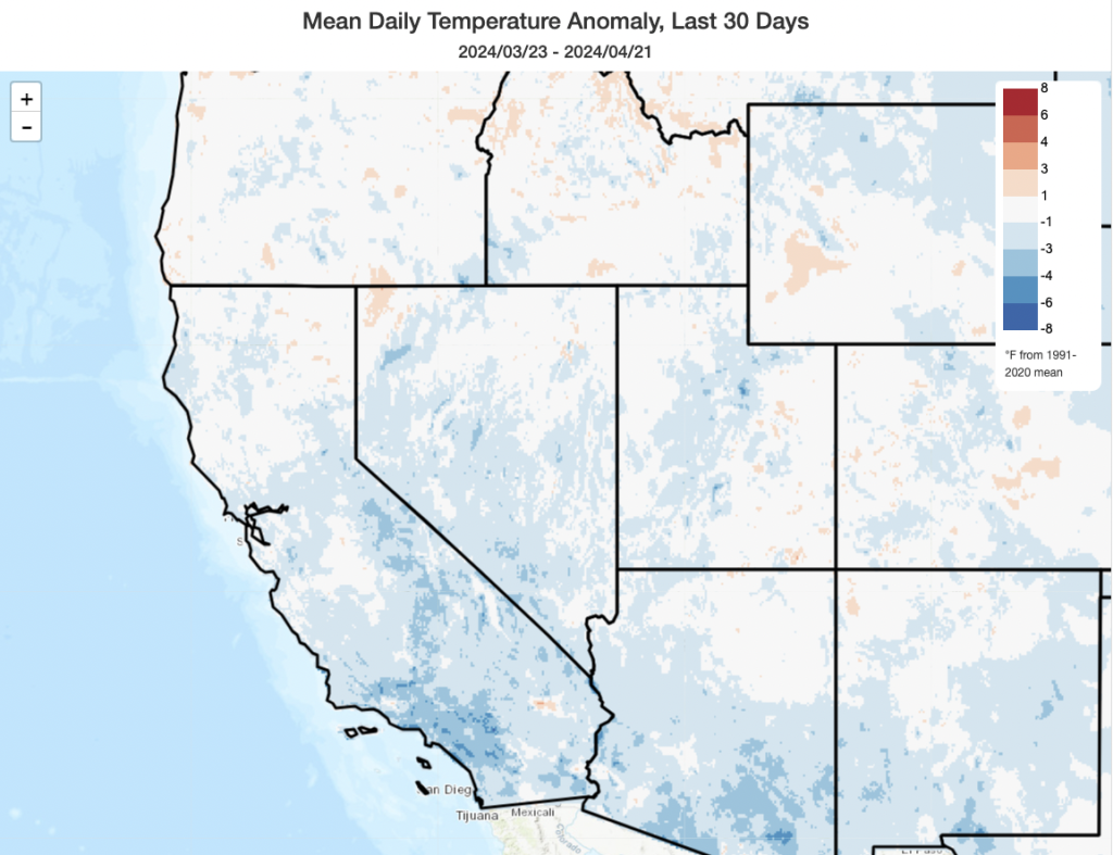
The last month or so has been, for the most part, a relatively damp and cool period across California. The coolness has been especially pronounced in coastal southern California, where a few observing sites have seen the coldest such 30-day period in several decades. Of course, as has come up in some lively discussion in the Weather West comments section, part of this is a symptom of “shifting baseline syndrome:” California, even during spring, is considerably (around 2.5-3F) warmer than it used to be a century ago. Yet much of that spring warming occurred prior to 1990–unlike other calendar seasons, where regional warming has accelerated over the past ~30 years and where recent years have shattered centennial records (repeatedly). This has, notably, not happened in spring–and I don’t necessarily have a clear answer as to why at this point. It’s quite possible this is essentially due to random variability in the ocean-atmosphere system (good or bad “luck,” depending on how you view it). It’s also possible that there’s something about the springtime circulation over the far NE Pacific that has tempered the erstwhile warming trend locally during this season only, but that’s essentially just speculation on my part and would require further study. And although this year doesn’t look like it’ll buck the recent trend of reduced springtime warming, it won’t last forever: as the entire planet continues to warm, California’s springtime warming will eventually resume (though it will be interesting to see if it continues at a slower pace than in other seasons).

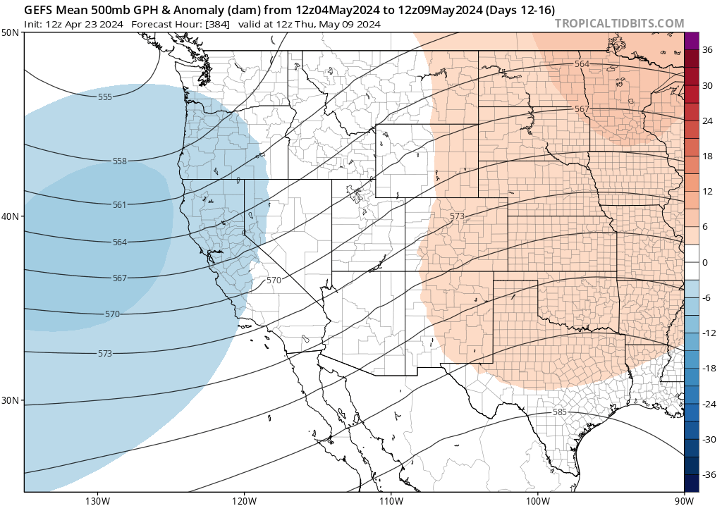
In any case, the relatively cool weather appears likely to continue across California for the next couple of weeks at least–and perhaps longer. A fairly unremarkable spring-like pattern will prevail across the West Coast during this period–with a slightly unsettled pattern of weak but possibly colder low pressure systems passing through at times. This will maintain CA temperatures at or slightly below the values typical of spring over the past few decades, with occasional chances for showers (particularly over the mountains and perhaps more broadly over NorCal). These will be colder systems aloft, so could still produce some brief Sierra snow accumulations and some isolated thunderstorm activity (especially over mountains and Central Valley). But right now, these colder and somewhat unstable systems do not look as impressive as the rather numerous ones which brought some dramatic local weather during March and early April.
A look ahead to late spring-early summer
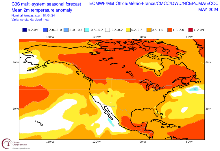
The coming summer and autumn very much has the look of a “good news, bad news” situation from a California-centric perspective. The good news? It looks pretty likely that mild temperatures (near or even locally slightly below the recent average) will continue through May and maybe June as well. We may continue to see at least scattered shower opportunities through May or early June in NorCal with the likely absence of any big ridges–that tends to happen most years in which there isn’t a clear mechanism for blocking late season but sometimes still-chilly lows. This is a reasonably good pattern for “May Grey and June Gloom,” so the usual marine layer cloudiness near the coast will likely be in place frequently. This means that most of CA will likely see a low risk (even lower than usual for May-June) of significant wildfire activity during this period, and snowmelt from our “remarkably average” mountain snowpack should be at a modest pace.
La Niña is coming, and possibly a very hot/dry late summer-early autumn?
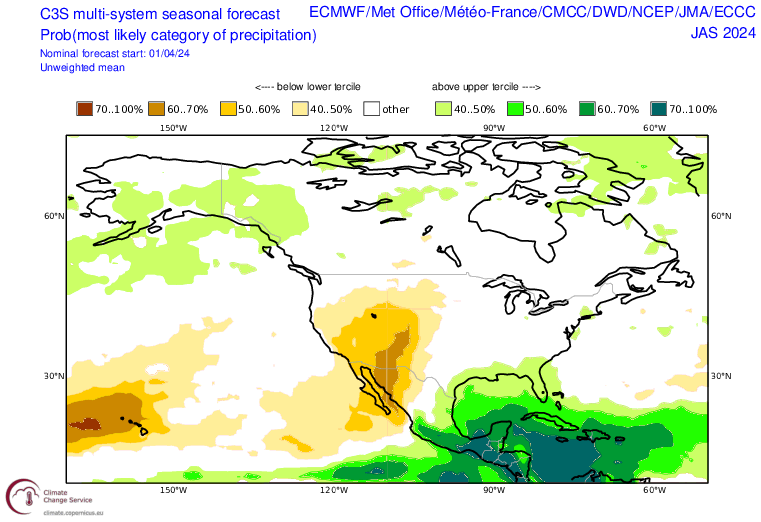
The bad news? I do not believe the relative coolness and dampness of May-June will continue into late summer and autumn. July may be a bit of a transition month, but by August there is strong multi-model ensemble agreement that California will become progressively more influenced by what might ultimately become an extreme and possibly record-breaking mid-continent ridge for much of the second half of summer. There is currently a rather extraordinary heat signal for much of summer across nearly all of continental North America–except for CA during the first half of summer–but the projected highly anomalous ridging and high heat potential does appear likely to expand westward to encompass even the West Coast by August and September.
In practical terms, this means that I’d expect to start seeing some rather intense summer heat events across the CA interior/SE desert region in July–with this anomalous heat extending increasingly closer to the coast (westward) from Aug-Oct. This would be, in essence, an exaggerated version of the seasonal progression that usually unfolds in CA: with heatwaves first affecting only the far inland regions of CA early in the season (with the coast remaining socked in with a cool/moist marine layer) but progressive offshore flow events allowing hot temperatures to make it all the way to the beaches by Sep/Oct. This year, I think it’s likely this pattern will be even more pronounced than usual–with a notably cool start to summer (especially along the coast) and a notably hot end nearly everywhere.
Additionally, present indications are fairly strong that summer 2024 could feature high odds of a weak North American Monsoon. With the caveat that monsoon predictability at seasonal scales leaves something to be desired, it is a plausible outcome in this ENSO transition year. If a weak monsoon with below average precipitation in the core monsoon region does indeed materialize, that would likely make the mid-continental ridge and projected extreme summer heat even more likely to materialize due to soil moisture feedbacks to the synoptic scale flow pattern.
This broader pattern has some interesting implications for fire season in western North America.
In California, the season is quite likely to start out even milder than usual (through at least June and perhaps July)–with the possible exception of the SE deserts, which may see early activity due to extensive vegetation growth from antecedent wetness over the past 12-18 months). If the monster mid-continent ridge and weak monsoon do materialize, though, and progress toward the coast in Aug-Sep–that mild start could rapidly transition toward above-average wildfire activity in California. This is for two reasons. First, there has been a lot of vegetation growth (“fuel build-up”) over the past 2 wet and relatively mild years in CA. There’s very likely more vegetative biomass right now in many parts of CA since before the historically severe droughts and wildfire activity between 2011 and 2020. Second, rapid warming and drying starting in Jul or Aug this year will likely lead to above-average wildfire activity over much of the interior West by mid-summer (and in New Mexico by early summer)–and that pattern will likely shift westward into California by that point. So, the combination of lots of recent vegetation growth (including in some of the large burn areas from the past decade, which will increasingly support re-burns), plus a fairly high likelihood of a hotter and perhaps also drier than-recent-average end to summer and autumn right when offshore wind seasons starts, indicates to me that this California fire season could end very differently than it begins.
Across the interior of the West, elevated fire conditions will likely develop earlier this year than in CA given that the persistent ridging/heat will likely materialize sooner. In western Canada, severe to extreme drought has persisted since last summer, and some “zombie fires” in the boreal forests have even managed to overwinter despite cold temperatures. Unless something changes dramatically and unexpectedly, it’s likely that western and parts of central Canada will see another severe fire season (following on the heels of last year’s historic one). That means that, unlike last year where North America was relatively quiet fire-wise with the dramatic exception of Canada, there’s a higher likelihood of widespread wildfire activity across much of the western part of the continent by July-August. That has significant implications for both smoke prevalence and firefighting resource management.
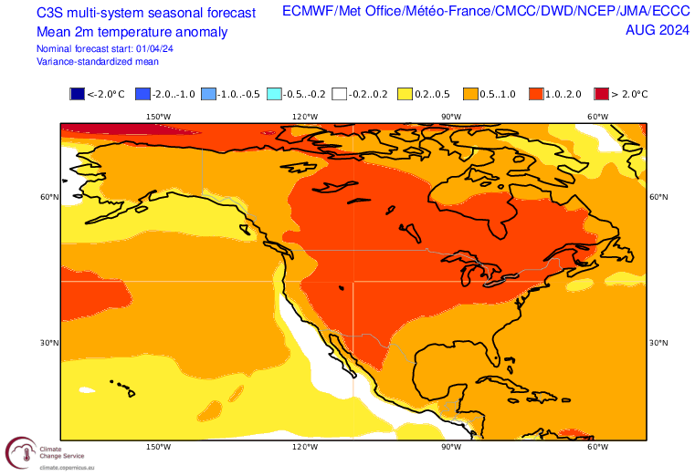
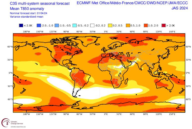
Finally, when we look at the late summer-early autumn period from a global perspective (here showing the superensemble average, across many models, of projected Ju-Sep lower atmospheric temperature anomalies), it looks…awfully hot. Perhaps record hot, once again, on a global basis (and this time, California might be participating–unlike last year or earlier this summer). What’s going on here? Well, global warming’s the biggest piece, of course. But the expected transition to a fairly robust La Niña event (which tends to favor relatively hotter summers in the mid-latitudes vs. relatively cooler summers closer to the tropics) will also play a role. Will the Earth continue to experience record-breaking warmth even with the transition to La Niña in 2024? Right now, the answer appears to be “quite plausibly”–at least for the next few months (that might change starting next winter).
