After mid-August reprieve, yet another prolonged California heatwave
A very hot summer thus far away from immediate coast; weak monsoon on western fringe

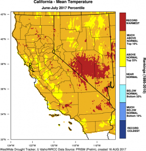
Summer 2017 has featured a recurring pattern across California, characterized by strong and persistent ridging just inland of the West Coast and prolonged, searing heatwaves across most interior portions of the state (and, indeed, across much of the American West). As has been widely noted, immediate coastal regions (within 10 or so miles of the ocean) have not been nearly as anomalously hot this summer due to the relative lack of the strong offshore winds typically required to bring hot temperatures to California’s characteristically chilly beaches. Nonetheless, warm ocean temperatures especially across the SoCal Bight have kept overall mean (and overnight) temperatures above average nearly everywhere. This combination has resulted in a rather curious situation where the majority of California is experiencing a “top 5” hottest summer on record, yet the majority of Californians (most of whom reside in densely populated coastal regions in the Bay Area and in Los Angeles/Orange counties) have witnessed comparatively mild conditions. Cities like Redding and Bakersfield are on track to approach or exceed all-time records for the greatest number of 100+ degree days in a single year, and it’s possible that other places will follow suit after another 1-2 weeks of prolonged hot weather to come.

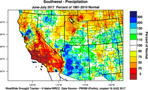
Another unusual characteristic of summer 2017 has been the relative absence of mountain/desert convective precipitation associated with the North American Monsoon. Interestingly, there has so far been a very strong east-west differential in monsoonal precipitation–with much of Arizona experiencing near record-wet summer conditions and some spots in the SoCal deserts experiencing near-record dry conditions. Part of the reason for this divergence is likely the persistence of high pressure on the western margin of the monsoon circulation, which has inhibited precipitation over most of California. There are still at least a few weeks left in the canonical monsoon season, and it’s often the case that California experiences a late-season surge in moisture/convective potential. Indeed, there is some indication that this very situation may evolve over the next couple of weeks (see below).
Upcoming heatwave will be prolonged, and will extend to coast in SoCal
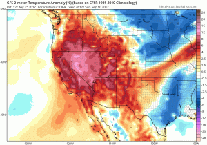
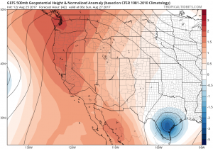
Unfortunately, this post will read something like a broken record: there is more heat on the way, possibly record-breaking in some spots, and this time it may extend closer to the immediate coastline (especially in Southern California). A strong ridge will once again build directly overhead this weekend, bringing hot weather to nearly the entire state. Weak offshore flow will bring hot temperatures all the way to the beaches in SoCal, and some daily record highs may be threatened. Further north, coastal areas may yet again escape the hottest conditions, but another very prolonged streak of triple digit weather is expected across most of California’s interior valleys.

A “second wave” of heat may develop by next weekend, preventing any meaningful cooldown. Current model forecasts suggest this one may be centered further north, and could once again bring record-breaking heat to the Pacific Northwest. If this second wave evolves largely as expected, numerous all-time cumulative “temperature threshold exceedance” records (i.e., most days above 90/100/110 degrees in a single year) may be broken in the Central Valley. At present, there are not really any indications of average or below average temperatures heading well into September (which is actually prime coastal heatwave season in California).
Models have variously suggested over the past few days that a fairly robust monsoonal incursion westward into California–affecting the mountains and deserts, and perhaps also the coastal plain–will eventually develop during the second week of this heatwave. Also in the mix is the potential for some tropical remnants to become entrained in southerly flow aloft–and it’s getting to be the time of year when that sort of pattern becomes more likely. So far this summer, the global models have overestimated the westward extent of monsoonal surges, so at this point we’ll just have to wait and see how this evolves in the 7-10 day period.
A California connection to potentially devastating Hurricane Harvey?

At the time of this writing, rapidly-intensifying Hurricane Harvey was approaching the mid-Texas Gulf Coast. There has been widespread consternation in the meteorological community over the past 48 hours regarding the potentially devastating impacts of this remarkable storm, which likely poses the greatest threat to human lives of any landfalling American storm since Hurricane Katrina. While the storm is currently approaching category 4 status (with sustained winds in excess of 120 mph), these destructive winds (and even the enormous storm surge associated with them) are actually not the primary concern associated with Harvey. Instead, the extremely slow-moving nature of this storm following landfall has the potential to generate truly astonishing rainfall accumulations across the Texas low country. Recent simulations from the ECMWF model, for example, are showing the potential for 50+ inches (over 4 feet!) of rainfall in less than 5 days. Needless to say, rainfall of even half this magnitude could produce widespread and devastating freshwater flooding–and the latest model forecasts would approach the largest rainfall totals ever observed in North America.
Aside from the potential for a weather disaster of national significance, Harvey is also interesting from a California perspective given the importance of the anomalous western ridge in “setting the stage” for a tremendous tropical rainfall event over 1000 miles away. Hurricane Harvey is already moving slowly, but will continue to decelerate and eventually stall over land within 100 miles of the Gulf of Mexico over the weekend–potentially remaining within 150 miles of the Houston area for the next 5-6+ days. This extremely sluggish movement will occur due to the combined influence of the powerful Western ridge (which will prevent westward movement and rapid dissipation over relatively arid West Texas) and the lack a of deep trough over the central U.S. (which will prevent Harvey’s circulation from being “picked up” by a larger passing storm). Thus, as the West Coast bakes amidst yet another prolonged heatwave, parts of the Gulf Coast may simultaneously experience an astonishing–and potentially devastating–tropical deluge. Stay tuned.
After mid-August reprieve, yet another prolonged California heatwave Read More »