Strong atmospheric river likely to bring widespread, perhaps severe flooding to Northern California on Monday
Potentially dangerous flood event this week across wide swath of Northern California

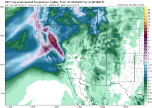
On the heels of a strong, damaging, and deadly Southern California storm on Friday, a new and powerful storm is bearing down upon Northern California. A deepening low pressure system just off the California coast will drag an extremely moist plume of subtropical moisture over the northern half of the state, bringing a prolonged period of moderate to heavy precipitation with high snow levels over a 36 hour period from late Sunday to early Tuesday. This brief update will focus exclusively on the major flood risk posed by this weather setup given extremely wet antecedent conditions.
Slow-moving atmospheric river may stall near Bay Area, Sacramento regions
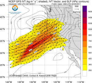
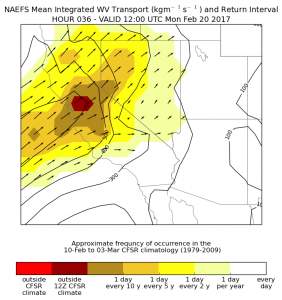
The atmospheric river associated with the Monday storm will be very impressive in its own right–the amount of atmospheric water vapor transport near the Interstate 80 corridor on Monday will be of a magnitude historically only seen every ten years or so in February. Even more problematic than the overall amount of moisture is that the atmospheric river boundary itself is expected to be very slow moving, and may in fact stall across some portion of Northern California.

As the offshore low lifts northeastward, the moist plume associated with the warm front will make slow progress northward during the day on Monday before reversing direction and moving more rapidly southeastward as the cold front approaches. The I-80 corridor (including the Bay Area and Sacramento regions) will be near the classic “triple point” of the warm, cold, and occluded fronts–which is a recipe for major flooding, since the atmospheric river can effectively “pivot” over a relatively narrow region. It’s still hard to pinpoint exactly which region will be most severely impacted, but I expect some serious flooding later Monday in a relatively narrow region somewhere within about 100 miles of the I-80 corridor. Even outside of this band of potentially dangerous rainfall accumulation, widespread heavy precipitation will still occur and lead to considerable flooding, mudslides, and other issues.
While the warm and wet precipitation will slowly taper off on Tuesday, it now appears that an active pattern will continue thereafter (albeit a much colder one). Additional precipitation accumulations may add to already considerable flooding later in the week, although at least snow levels should be drastically lower by Wednesday, reducing overall runoff.
Widespread flooding likely; severe stresses on California’s water infrastructure

California is currently in the midst of one of its wettest winters on record, and precipitation since January 1st has already led to widespread water-related impacts. Widespread inundation of agricultural lands is occurring, which has begun to spread into low-lying nearby communities in the Central Valley; innumerably many mudslides and landslides have been occurring almost continuously in Northern California, causing numerous roadway failures and affecting some heavily traveled routes; and most of California’s major and minor reservoirs are now nearing capacity, requiring large water releases. All of this water is severely taxing California’s water storage, conveyance, and flood protection systems. With the major exception of the Oroville Dam spillway crisis–a situation that appears to have stabilized for the moment–no major failures have yet occurred elsewhere.
But given the magnitude of the incoming Monday storm and the precariousness of the present situation, it’s becoming increasingly likely that problems will arise this week. As others have pointed out, the present situation is very similar to those which have historically resulted in major levee failures in the Central Valley and Delta regions. Undoubtedly, this week’s weather will be a serious stress test for California’s aging water infrastructure. Indeed, the potential exists this week for severe flood-related impacts of a magnitude not seen in many years. This is a storm to take seriously!
I’ll be following this high-impact storm and its impacts in real time on Twitter.