Unusually strong April storm headed for Northern California this week
Recent weather overview
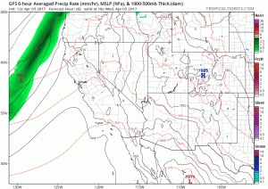
After a record wet winter across much of Northern California (and a less impressive but still above average winter in Southern California), March was a relatively dry month across most of the state. This was especially true across the southern third of California, where little to no significant precipitation occurred amidst warmer than average temperatures. These relatively early spring-like conditions not only mean that Sierra snowmelt season is in full swing, but also have combined with prodigious winter rains to produce spectacular wildflower displays across southern and central California.
Unusually strong April storm to bring high-impact weather to much of California
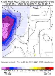
Despite the warm and relatively dry interlude over the past few weeks, it now appears quite likely that winter-like weather conditions will return rather suddenly over the next couple of days. Northern California will be in the crosshairs of an unusually powerful late-season Pacific storm system from Thursday into the weekend. A pair of pretty deep surface lows are expected to spin up just offshore the North Coast, bringing strong and perhaps even damaging winds to a wide swath of Northern California (perhaps as far south as the Bay Area and Sacramento region). In fact, the surface low off of the Oregon coast on Friday afternoon will probably approach record strength for this time of year, since deep lows typically become uncommon in this region once April rolls around. There is still some uncertainty regarding the exact placement and strength of this relatively complex storm system, which could lead to a fairly wide range of wind and rain impacts. In general, however, I would expect this to be quite an impressive storm for this time of year, and will possibly be the strongest system to affect California since February. The upcoming weather will be remarkable primarily due to its late seasonal timing, however, and is unlikely to rival the very strong storm systems California experienced during December and January this past winter.
Atmospheric river to bring heavy rain and mountain snow
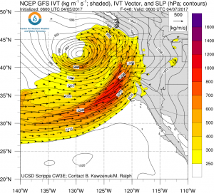
A rather strong atmospheric river will be associated with the Friday/Saturday storm across Northern California, and will bring the potential for heavy late-season precipitation (especially in orographically favored regions). There is still some uncertainty regarding just how warm the initial precipitation will be, and it is possible that rain may fall above pass level in the Sierra Nevada due to a warm antecedent springtime airmass. By Saturday, however, cold air will likely drop snow levels considerably, bringing at least small snow accumulations down to 4000 feet or so. Therefore, it’s possible that this storm system will be yet another that yields considerable net snowpack at the highest elevations (above 7000-8000 feet) and reduces net snowpack below that level. Thus, there will be a risk of flooding from the combination of heavy rainfall and snowmelt at lower elevations, which may continue well into next week as temperatures warm behind the storm and clear sky snowmelt accelerates. Outside of the Sierra Nevada, only minor hydrological issues are expected given relatively dry antecedent conditions.
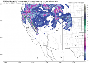
The Central Coast could see significant precipitation from this weekend’s storm, though most of Southern California will likely only see light rainfall and little wind impact.
It’s that time of year: thunderstorms likely in Central Valley; possibly elsewhere
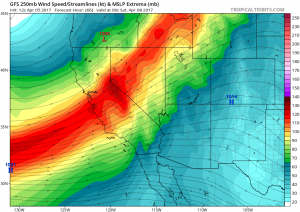
Cold air aloft and the close proximity of multiple surface lows will be conducive to convective instability across much of Northern California on Friday and Saturday. As is often the case in these sort of situations, the Central Valley will likely be an area of enhanced activity due to increased surface heating and topographical effects. A few severe thunderstorms are possible, especially if there are enough breaks in the clouds between waves of precipitation later Friday into Saturday. The air aloft will be sufficiently cold that fairly widespread showers of small hail could occur. All in all, it looks like a pretty active weather period for the northern 2/3 of the state, with some modest showers across the south.
Warming tropical Pacific: rumblings of a new El Niño?
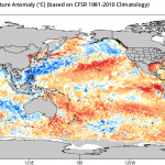
Extremely warm ocean temperature along the immediate Peruvian coastline have led to devastating flooding in normal arid coastal desert regions in recent weeks. This warming has resulted from reduced cold water upwelling associated with the Humboldt Current, which has historically been linked to the early development of significant El Niño episodes. While we’re still in the midst of high predictive uncertainty associated with the “Spring Predictability Barrier,” numerical models are nearly unanimous in suggesting a trend toward renewed warming of the tropical Pacific over the summer months. It’s still too early to say much more than that, but if current trends persist I’ll eventually have a more extensive discussion of what a new El Niño event would mean for California in light of the failure of the powerful 2015-2016 event to bring heavy precipitation to the Golden State. Stay tuned!
Unusually strong April storm headed for Northern California this week Read More »