Subtropical moisture plume bringing heavy Sierra Nevada precip; widespread active weather this week
Ongoing atmospheric river event bringing heavy rainfall in Sierra Nevada

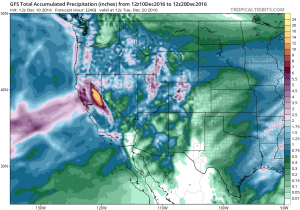
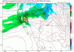
I’ll cut to the chase in this post, since it’s looking like an active pattern may bring some high-impact weather to much of California over the next 7-10 days. The first of these events is already underway–an abundant plume of subtropical moisture is streaming northeastward over the far eastern Pacific and bringing copious rainfall to the western slopes of the Sierra Nevada. Note that I did specifically say “rainfall” as opposed to snowfall–snow levels are well above 7000 feet in most instances (not surprising, given the warm, low latitude origins of the airmass over California). Heavy rainfall is melting some of the lower elevation snowpack that has developed in the 5000-7000 elevation band–causing heavy runoff into Sierra Nevada streams and rivers. The Truckee River is already expected to crest above flood stage this weekend (and may do so again later this week–see below).
Some heavier rainfall has also been falling in a relatively narrow west-to-east oriented band near the Bay Area, but for the most part significant precipitation and flooding issues have thus far been confined to a relatively small portion of the Sierra Nevada. With this particular atmospheric river event, California’s orograhically-induced rainshadowing is in full effect (keeping Silicon Valley and the Central Valley much drier than the adjacent windward mountain slopes). In the absence of a strong nearby storm system, the extremely moist plume is squeezing out quite a bit of moisture in the hills and mountains but very little closer to sea level. This is a defining characteristic of atmospheric rivers that arrive “unattached” to a parent storm system.
Subtropical moisture plume may interact with Arctic airmass later this week

Mid-latitude weather is, at its core, driven by “clashes” between airmasses of opposing character. That’s why the American Great Plains constitute the world’s epicenter of severe weather and tornados–there is no other place on Earth where geography allows air as warm and moist as that from the Gulf of Mexico to interact with air as cold and dry as that coming from the Canadian interior. Here in California, the opposite situation is typically the case: it’s actually quite difficult to get either warm/moist OR cold/dry airmasses to come anywhere near us, let alone at the same time. But it’s looking like that may happen to some degree later this week, when a persistent subtropical moisture plume meets a surge of unusually cold Arctic air diving down the West Coast from Canada.
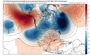
Why is this unusual confluence of Arctic and subtropical airmasses likely to occur over California this week? A pronounced “Omega block” (characterized by a strong high pressure center with satellite low pressure centers to the southwest and southeast) has set up shop near Alaska, which has allowed bitterly cold air to spill out of the Arctic and over the northern North American continent. This airmass has thus far made it as close as the Pacific Northwest, where significant snowfall has blanketed areas from Portland to Vancouver for the first time in several years (even at sea level). At the same time, the southeastern low pressure center associated with the quasi-stationary Omega block has set up shop near Hawaii, which is generating a nearly continuous plume of warm/moist air that is heading in the general direction of California.

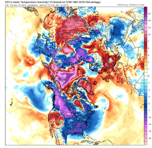
It’s interesting to note that the Arctic basin itself remains extremely warm relative to average for this time of year–and that the Alaskan blocking pattern is occurring very close to the region of ongoing record low sea ice extent in the Bering Sea. At least in a proximal sense, it does appear that the upcoming unusual weather pattern in California this week is related to the extremely anomalous circulation pattern in the Arctic.
High uncertainty for coming week, but strong storms/low snow possible
With such a complex and energetic flow pattern over the northeastern Pacific, it’s very hard to say just how the weather will evolve over the coming week. With a strong “baroclinic” region over California (i.e. a zone of very strong temperature contrasts), it’s possible that deep surface lows could develop fairly rapidly and bring substantial heavy rain (and perhaps strong wind) events to California. It’s also possible, though, that much of the state just sees a steady stream of weak-to-moderate impulses that bring hefty precipitation accumulations in the mountains but modest amounts elsewhere. Current model forecasts have been waffling back and forth between these two possibilities, but I would expect to see at least one significant storm event in California this week. Early, precipitation will remain confined largely to northern and central California, but by later in the week there will be an increasing possibility for rain and wind to reach southern California.

In either scenario, however, heavy to very heavy rainfall is likely in the central Sierra Nevada, and if things pan out as currently projected there could be some significant flood concerns in this region later this week (especially given the response of rivers already to this weekend’s precipitation).
There is a fair bit of model agreement that no matter what happens this week, the active weather phase will slowly start to taper off after next weekend. But as it does so, a very cold airmass may settle further southward across California, perhaps bringing drastically lower snow levels and sub-freezing overnight temperatures. It’s still too early to say just how cold it might get or just how low snow levels may drop, but it is highly likely that heavy Sierra Nevada snow accumulations will occur with late-week precipitation as snow levels plummet following the atmospheric river and the arrival of the Arctic front.
For more frequent updates as this week’s storms develop, follow Weather West on Twitter!