Powerful, potentially damaging storm to bring very heavy rainfall and high winds to Northern California
Summary of recent conditions
This section will be very brief, as the main focus of this post is the imminent very strong storm system slated to affect most of California later this week.
Over the past week or so, significant and locally heavy precipitation has fallen across most of California. Soils in many parts of Northern California are now nearing/at saturation due to recent rainfall, and regional rivers and streams have begun to respond to recent precipitation. Thus, antecedent conditions are now conducive to an elevated risk of flooding and mudslides (despite the ongoing extreme long-term drought), and additional heavy precipitation (as is expected this week) will result in rapid rises on waterways in Northern California.
Very strong storm–perhaps strongest since 2008–will arrive in California late Wednesday
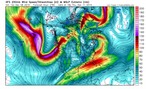
The numerical weather models are now in strong agreement that a powerful Pacific winter storm will slam Northern California later this week, bringing very heavy precipitation and very strong winds. In many ways the upcoming event is a textbook major storm setup for Northern California, with an impressive strengthening of the East Asian jet extending clear across the Pacific Ocean and driving a rapidly-deepening surface low pressure area off of the coast of far northern California.
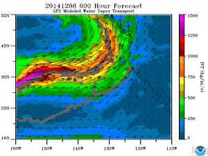
Associated with this well-defined trough and strengthening low is a rather impressive atmospheric river–or narrow region of highly concentrated atmospheric water vapor transport–a phenomenon that is often linked with extreme precipitation and flooding along the West Coast of North America when other atmospheric conditions are favorable. This week, it does indeed appear that all the ingredients may come together for a very high-impact storm event, especially across the northern half of the state. Preliminary indications suggest that wind speeds with the upcoming system may be of a similar magnitude to those experienced during the noted January 2008 event, which brought widespread significant impacts to a broad swath of NorCal. Precipitation from the upcoming system may be even more impressive than that experienced during the 2008 storm, as some of the models are spitting out very impressive 36-hour totals for California’s lowlands and urban areas.
A bit of meteorological context
The Wed/Thurs system will be notable not only for its copious moisture content (associated with the strong atmospheric river), but also for its impressive dynamical/large-scale characteristics. Recent model solutions suggest that the surface low will be deepening rapidly as it approaches the coast, which is historically a favorable setup for major wind events in Northern California. In fact, some of yesterday’s model solutions deepened the surface low to around 976/977 mb–which would be quite strong for this part of the world.
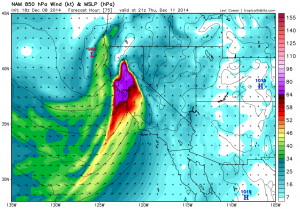
Today’s model runs are not trending quite as deep with the surface low, though they still depict a sub 990 mb low near the California coast by late Wednesday. It’s worth noting that the global numerical models sometimes underestimate the rate of strengthening of rapidly-deepening extratropical cyclones such as this one, so it remains possible that yesterday’s deeper solutions may end up being closer to the truth. Either way: 850mb wind speeds in excess of 65-70 kts suggest the potential for strong and potentially damaging winds at the surface, and especially in the hills/near the water.
In terms of precipitation: heavy rainfall is likely across essentially all of NorCal during this event, since large-scale ascent will be quite strong ahead of and near the time of frontal passage. In addition, highly efficient orographic enhancement of precipitation across elevated terrain will occur as southerly winds impinge on the Coast Ranges and Sierra foothills, especially as the atmospheric river moves ashore. Thus, very heavy 3-day precipitation totals in orographically-favored areas are likely. Of potentially greater concern are the very high rain rates which may occur around the time of frontal passage. Large-scale upward vertical motion will be quite strong during this event, and there will be enough instability for some embedded thunderstorms along/behind the front. Thus, there will likely be the potential for some flash flooding across a broad swath of Northern California, focused particularly on urban areas and streams/small rivers draining the foothills/coastal mountains (which will respond quickly to torrential downpours). Burn scars from summer wildfires in the Sierra foothills will also be at considerable risk of landslides and debris flows throughout this event. Additionally, there is a small chance that the rapid deepening of the surface low will cause the cold front to stall out for several hours somewhere near the I-80 corridor, which could locally enhance the flood threat there.
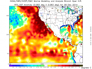
One additional thought: near-shore ocean temperatures off the coast of California remain exceptionally warm, which has been contributing to California’s record warmth this year. As witnessed during last week’s storm, these warm ocean waters have also led to a local increase in near-shore atmospheric instability during convective regimes and may also be acting as a source of additional lower-atmospheric moisture during storm events this winter. Thus, it’s possible that these exceptionally warm ocean temperatures could modestly boost precipitation rates associated with the upcoming heavy precipitation event, especially near the coast.
Primary storm impacts: very heavy rainfall (and likely flooding); very strong winds (possible wind damage)
The National Weather Service has already issued a Flash Flood Watch and High Wind Watch for most of Northern California. As noted above, very heavy precipitation and very strong winds are possible. Widespread 3-day rainfall totals of 2-4 inches are expected, with totals in orographically-favored areas possibly exceeding 10 inches. Precipitation intensity will be quite high–this will not be a gentle, soaking rainfall–which enhances the flood threat considerably. In terms of wind: there is still some uncertainty regarding whether winds will be merely strong or perhaps damaging. While recent model solutions have come in slightly weaker, some solutions from the past several days suggest the potential for gusts in favored areas near or in excess of hurricane force.
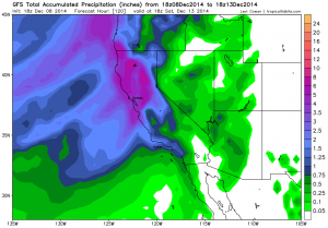
Winds in urban areas will probably remain below these rather severe levels, though given the prevalence of drought-weakened trees the observed impacts of widespread wind gusts in excess of 50 mph could still be quite high. If the surface low attains a depth closer to what was being suggested yesterday by the models, damaging winds could become more widespread across Northern California. Finally, heavy snowfall and possible blizzard conditions will occur in the high Sierra, with snow accumulations likely being measured on the order of feet before all is said and done. This will not be a particularly cold storm, however, so below 7000 feet or so some of the precipitation may fall as rain rather than snow (though snow levels will drop pretty quickly after frontal passage and bring snow to most of the Sierra Nevada range by the end of the event).
It’s worth noting that while the entire state is likely to see wind/precipitation from this event, the most significant impacts are likely to be centered on Northern California. Southern California will probably not be at a significant risk of flooding/wind damage from this storm, as it does not have particularly low-latitude origins. Geographically speaking, though, this will be a very significant event for most of the state, and will have substantial implications for the state’s largest and most important watersheds.
More on the horizon?
More rainfall may be on tap following this week’s powerful storm. While subsequent storms are unlikely to be as strong as the one currently forming off the California coast, a progressive flow pattern over the Northern Pacific will bring periods of active weather to California over the next couple of weeks. Rainfall and snowfall of this magnitude will bring considerable short-term drought relief to much of California, though (as I will discuss more extensively in a future post), we still have a very long way to go in order to mitigate our enormous long-standing rainfall deficit accumulated over multiple consecutive very dry and record-warm years.
Note: I will provide micro-updates on this week’s powerful storm on the Weather West Facebook and Twitter pages.
© 2014 WEATHER WEST