NorCal deep freeze on Tuesday; rain returns on Wednesday: winter has finally arrived in California
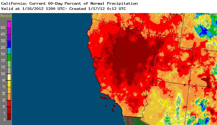
Well, it does certainly appear that the remarkably quiescent and dry weather pattern that has persisted nearly throughout California since November is finally coming to an end. After more than two months of extremely dry conditions during what is normally the height of the rainy season, nearly the entire state has accumulated some truly impressive precipitation deficits. Most of Northern California is experiencing hyrdological drought according to NOAA’s Palmer Drought Severity Index, with a good portion of the Sierra Nevada squarely in the “severe drought” category. Fortunately, though, these metrics are based primarily on short to medium-term soil moisture, which (as those who have lived in this state for more that a few years already know) can change quite quickly under the right circumstances. And it starting to appear that conditions may be right for some very significant precipitation over the next 10 days.

First things first, though: a very cold Arctic airmass has invaded the Pacific Coast of North America over the past few days, bringing snow all the way down to sea level in Washington, Oregon, and even briefly on the beaches of the far north coast of California. The entire state of Washington, and much of Oregon, are expected to receive heavy and possibly record-setting lowland snowfall over the next 3-4 days, with accumulations exceeding 12 inches possible all the way down to sea level near Seattle. While California is unlikely to see any extraordinarily low snow levels this week (outside of the possibility of a few more flurries along the far North Coast early Tuesday morning), a long-duration (and possibly record-setting) deep freeze is already underway across much of NorCal this evening. Temperatures by 11 PM had already dropped into the 22-27 degree range across large parts of the Sacramento Valley and were already below freezing across much of the Bay Area. With dewpoints mostly in the low 10s, record low temperatures are likely across large portions of NorCal on Tuesday as surface temperatures drop into the low to mid 20s in most locations and even as low as 12-17 degrees in the coldest valleys, even near sea level. In short, tomorrow morning will be very cold by NorCal standards, and there will probably be some agricultural damage and perhaps even some burst pipes as a result.
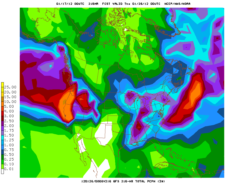
These cold temperature, though, will not last long. By Wednesday, warm and very moist air will initially override and eventually displace the cold and dry Arctic airmass over California as a strong zonal jet–yes, finally, a strong zonal jet!–noses into the far northern part of the state. Rain will begin slowly over far NorCal on Wednesday and spread southward through Thursday, reaching the Monterey Bay Area by late in the day. PWs over 1.5 inches are associated with these incoming systems, and there will be a moderate low-level jet acting to squeeze out some fairly high precipitation rates over the Coast Ranges and the Sierra Nevada. This sort of precipitation will be highly beneficial, since rain rates will not be high enough to cause any flooding problems but accumulations will be rather significant, perhaps on the order of 2-4 inches in the higher elevations, with 1-2 inches elsewhere. A similar storm is expected to arrive by Friday and drop a similar amount of precipitation across NorCal. The first storm probably won’t make too much headway into Southern California, perhaps bringing some light rain, but the second system will probably bring at least some precip to the entire state.
Probably of greater interest is the possible evolution of the pattern days 7-10. The extended forecast models–and the GFS in particular–are showing early indications of what could be a very significant precipitation event on Day 8. It appears that a large and deep cyclone off of the Washington and B.C. coasts may set up a long and deep band of subtropical moisture convergence somewhere along the Pacific Coast. With the presence of a very strong zonal jet (and also a low-level jet enhancement near the coast), this is a setup that has the potential to produce heavy precipitation where the moisture plume hits the coast. The 00z GFS focuses this plume on Central California, bringing very heavy 48-hour precip totals to the Bay Area next Tuesday. This is still over a week out, and very much subject to change, but it ‘s worth keeping an eye on considering the soil-saturating rains expected over the next 7 days over the northern 2/3 of the state.

In any case, one statement can be made with very high certainty: winter is, at last, on our doorstep. Stay tuned.
© 2011 WEATHER WEST