Active, wetter and cooler pattern to return to CA during late March
2023-2024 was a notably warm and wet winter in CA and the West (with a few exceptions)
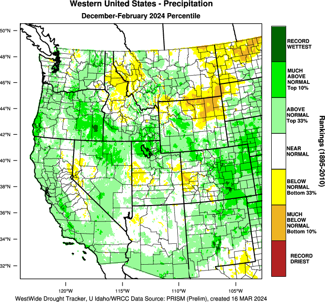
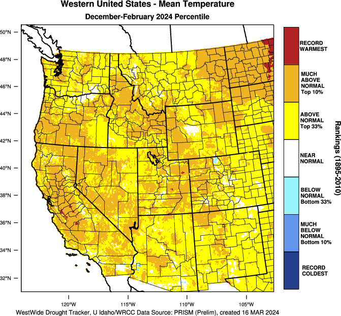
Well, it’s official: Winter 2023-2024 ended up broadly warmer and wetter than average across the Western U.S. There were essentially no exceptions to the “warmer” half of the coin, though some regions were warmer than others (including the San Joaquin Valley, where this past winter was either the warmest or second warmest in over a century of record-keeping depending on where you were). There was a bit more variability in the precipitation department, with the main exception of interest to the Weather West audience likely being the Tahoe/Reno-area “doughnut hole” of slightly drier than average conditions. Still, most of CA ended up wetter than average this past winter (including all coastal areas), and a few spots (mainly in patches of central and southern CA) ended up in the top 10% of wettest years on record. This does include a fairly dry and unremarkable December in some areas, so the Jan-Mar statistics may be even more impressive on the wet side in SoCal (I would expect a wider region of top 10% coverage, in accordance with our “back weighted” winter). Sierra snowpack is right around average for the calendar date on a statewide basis (slightly above in the north, and slightly below in the south–with some elevational separation as well with above-average SWE at high elevations but below average SWE in lower elevations–a distribution we’ll likely see more frequently in a warming climate). All in all, this has turned into a solid water year for most of California, but still a rather different one from last year (it has been *much* warmer, and the snowpack, while pretty good, is dramatically smaller–so I would not expected to see greatly elevated spring snowmelt flood concerns this time around unless there is a sustained extreme heatwave in April/May).
Active pattern to reemerge, with wet & cooler conditions across much of CA through early April
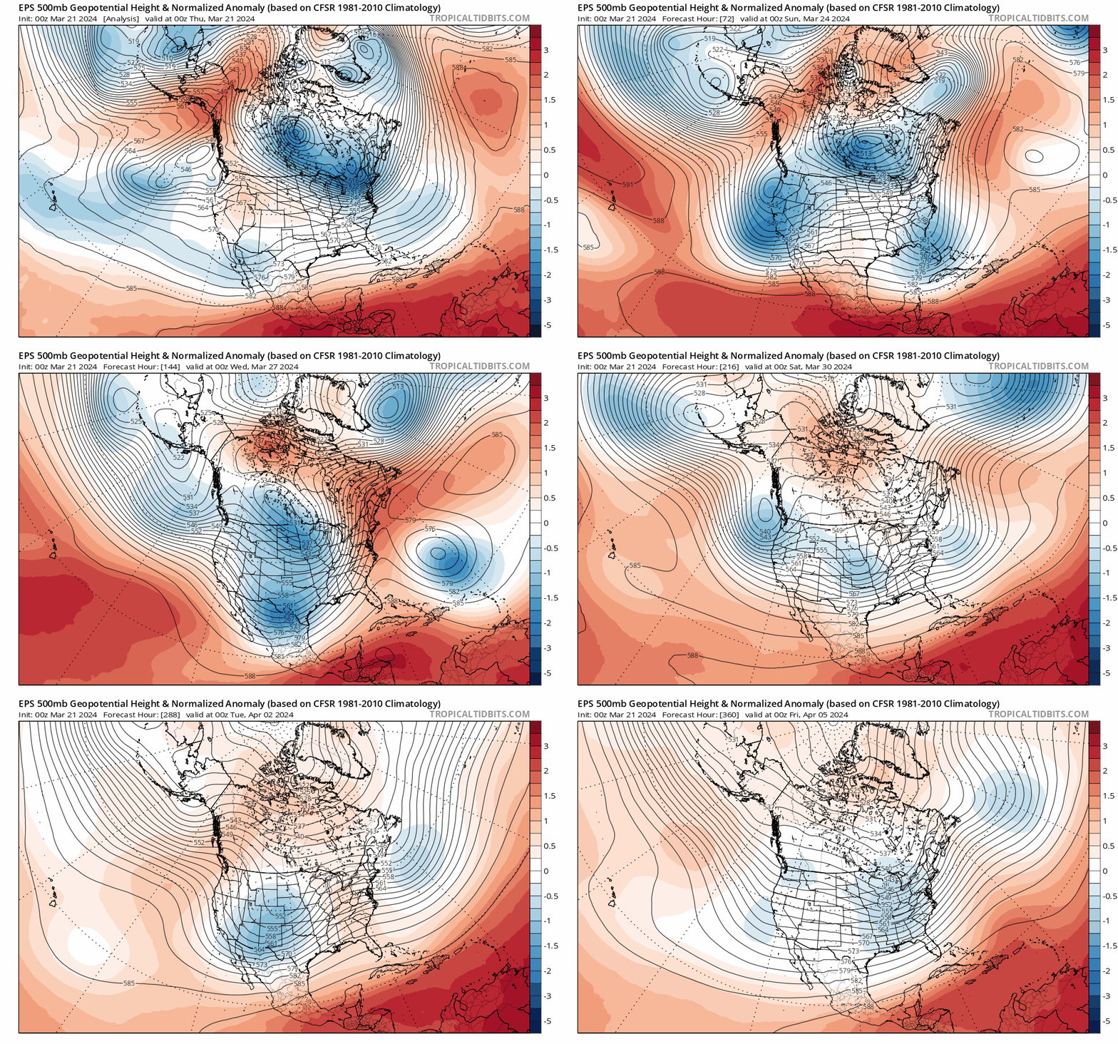
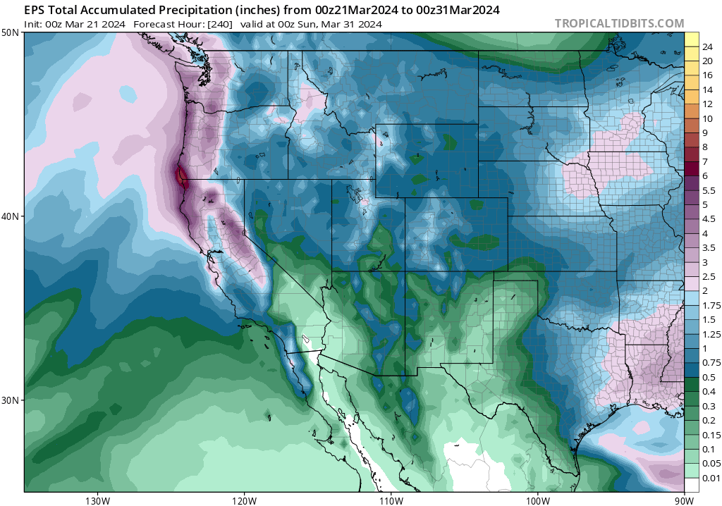
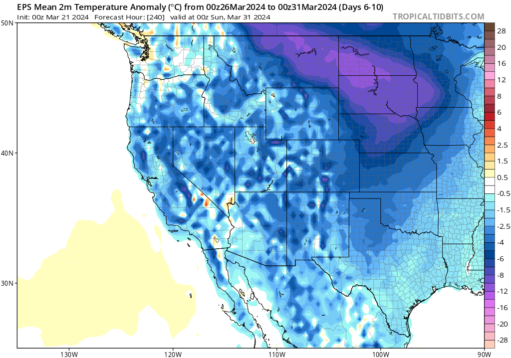
While the winter season may be drawing to a close, it looks like California and the broader West will see at least one more 7-10+ day period of winter-like conditions beginning this weekend. A series of 3-5 weak to moderate storms will affect California in the next 10-14 days, bringing widespread precipitation (especially NorCal) and cooler temperatures. These appear to be fairly decent snow-accumulating storms for the Sierra–no epic blizzards, but the highest elevations could accumulate several additional feet over 10+ days and there will likely be at least some accumulation to much lower elevations at times. Widespread light to moderate rainfall is likely throughout northern CA at lower elevations, and locally into SoCal as well (especially starting in about a week, when a couple of these storms will likely be a bit stronger and take a more southerly path than the first 2).
All of these systems will be associated with fairly cold air aloft, and when combined with the late March sun angle that tends to yield the potential for at least isolated thunderstorms with each such system. Indeed, most models predict several episodes of elevated surface-based instability over portions of CA between now and early April, which supports that notion. Thus, I’d expect these systems to be fairly episodic/showery but potentially with some heavy downpours at times given the potential for convection. (This sure has been a thunderstorm-y winter in California!) There may even be one or two opportunities for some localized severe thunderstorm activity, including mini-supercells in the Central Valley, at some point during this window as well when periods of elevated surface-based instability coincide with favorable jet structure overhead (perhaps allowing for some rotation of thunderstorm updrafts). It’s too early to time those windows at this point, but…tis’ certainly the season.
This active pattern looks like it will continue at least into early April, with some uncertainty regarding how persistent it might be beyond that point. It’s possible that this is winter’s last gasp–though there is some historical precedent for springs following stronger El Nino winters to be fairly wet and active in CA (so we shall see). Right now, though, it does appear the upcoming pattern will offer a further “top-up” to what is already a respectable snowpack and water year in the state.
Say goodbye to El Niño (and hello to La Niña?)
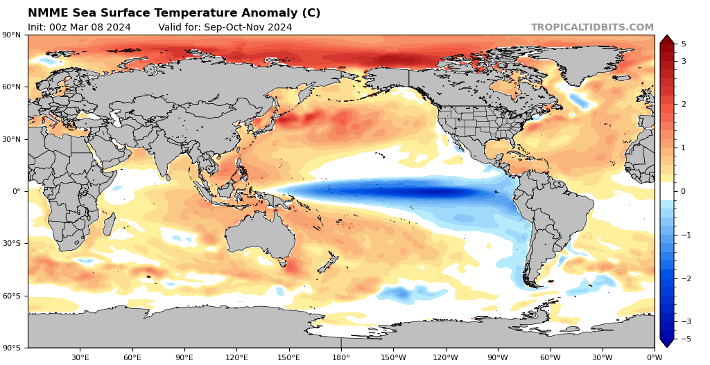
El Niño has been fading in recent weeks, though one final westerly wind burst appears to have postponed its last gasp. But there is unanimity in model projections, which would be consistent with basic theory that predicts especially rapid attenuation following the strongest warm ENSO event, that El Niño will continue to fade until it disappears sometime sooner vs. later this spring. This means that the atmospheric response to El Niño is now decreasing, and will approach zero in the coming weeks.
After that, nearly all the global predictive models are quite aggressive in predicting the emergence of La Niña (cool ENSO) conditions by later this summer and continuing to strengthen into autumn 2024. Normally, predictive skill for ENSO events 6+ months in advance would be relatively low, but I do believe in this instance that we may be in a window of “enhanced predictability” where I have more confidence in these long-lead ENSO predictions than I would in an average year. So there’s a pretty good chance the Earth will be experiencing substantial (and possibly strong) La Niña conditions by next autumn. This could well have implications for seasonal conditions next autumn and winter in California, including fire season. It’s still a bit too early to have that conversation in this blog post, but I’ll be gearing up to have it in the coming weeks. Stay tuned.
Check out my live, interactive Weather and Climate Office hours on YouTube!
The next one will be on Monday, Mar 25 at 10am Pacific Time–and the focal topics will be both the upcoming wetter and cooler weather pattern in California as well as new thoughts about the broader climate change context surrounding ongoing and recent record-shattering global warmth in 2023-4 (and what it does, and doesn’t, tell us about our understanding of the relevant underlying physical processes).
Active, wetter and cooler pattern to return to CA during late March Read More »