Unusually intense and prolonged early-season heatwave developing across California
Following recent NorCal rains, a dramatic shift to hot/dry conditions
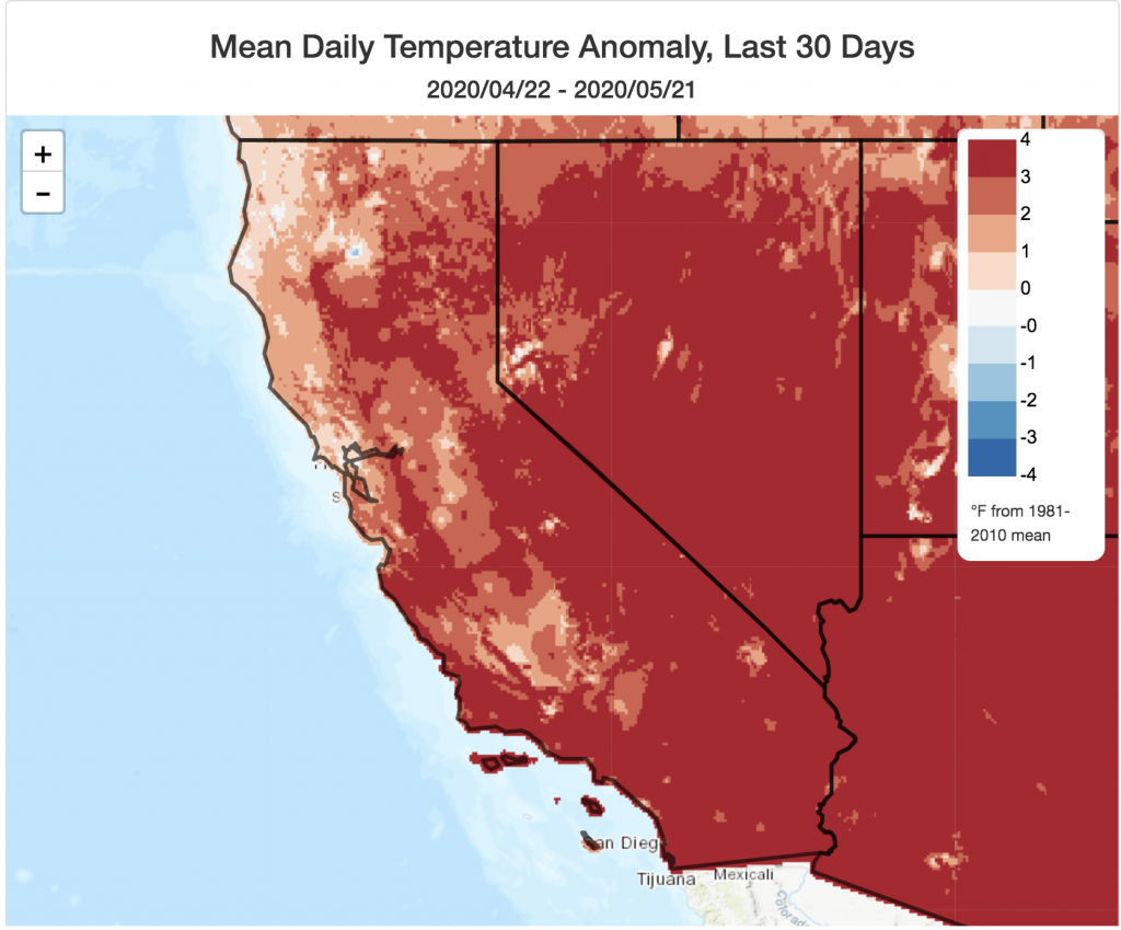
It has been an unusually warm spring so far across nearly all of California, but it has also been a pretty wet spring in southern California. Recent rains finally brought some temporarily relief to northern California, although outside of a few favored areas (which saw several inches of precipitation), accumulations were generally pretty light. Most of NorCal remains under moderate to severe drought conditions, however, following an exceptionally dry winter–and this legacy of curtailed winter rains (and, now, a very warm spring) will likely be with us through the summer and autumn to come.
Fire season–which had been off to a very early start across NorCal–was temporarily damped down by this welcome addition of late-season moisture. But it now appears that this fire weather reprieve will be pretty short-lived, as a remarkably intense heatwave builds across California over the coming week.
Intense, prolonged, and likely record-breaking May heat wave this week
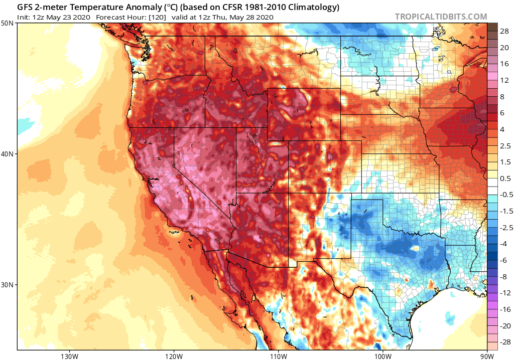
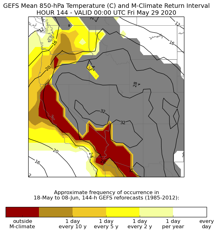
A pretty unusual large-scale atmospheric pattern over the northeastern Pacific Ocean and inland over the Southwest will contribute to a strikingly intense and persistent statewide heatwave this week across California. Indeed, extreme and in many cases record-breaking heat will actually extend across a pretty broad chunk of the American SW in the coming days–not just California. Heat will begin building today, but will become noticeably oppressive in some places by Monday. The heat will continue to intensify Tuesday, Wednesday, and possibly through Thursday before reaching a very impressive peak–especially across NorCal. Widespread daily record highs are expected, especially in NorCal, on multiple successive days (likely in some spots from Mon-Thurs). Right now, the high-resolution models are suggesting that this week’s extreme heat will be most anomalous across portions of the San Francisco Bay Area, where I would not be entirely surprised to see some monthly (not just daily) heat records fall. But ensemble forecasting tools are also suggesting that 850mb temperatures could approach/exceed record levels across an even broader region by Wed/Thurs–so there is some potential for this upcoming heat event to “outperform” even these pretty lofty predictions.
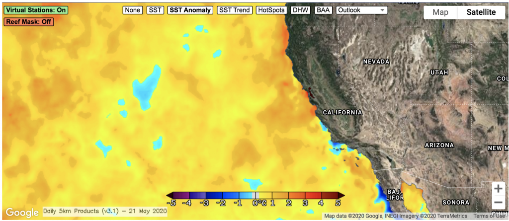
This heatwave will be noteworthy for at least two reasons in addition to its daytime intensity and multi-day persistence. First, this is a very early season heat event that is expected to affect the immediate coastline, which is pretty unusual. Typically, a very robust marine layer and cool seabreezes create strong thermal contrasts between the California coast and inland regions during spring/early summer heatwaves. But the May Gray will likely be nowhere to be found during this upcoming event. Why? Well, ocean temperatures are now well above average levels along nearly the entire CA coast due to a pronounced lack of cold water upwelling in recent weeks. Ocean temperatures are locally as much as 3-5F above average–which will limit the degree of “natural air conditioning” during this heat event and will also contribute to higher than usual atmospheric humidy during this event. These higher-than-usual humidities during an intense heat event will 1) limit the amount of overnight cooling–a key predictor elevated heat-related health impacts, and 2) make daytime temperatures feel even more oppressive than usual. (During many California heatwaves, low humidity makes the “apparent temperature” feel lower than the actual air temperature. Unfortunately, that humidity-related relief will not be available to Californians this week). All in all, this is shaping up to be a potentially high impact heat event across much of California–especially given that a higher-than-usual fraction of folks are staying at home, away from crowded beaches and public parks and in many cases without air conditioning, due to the COVID19 pandemic.
Some atmospheric dynamics: “Rex” to “Omega” block ensures prolonged heat event
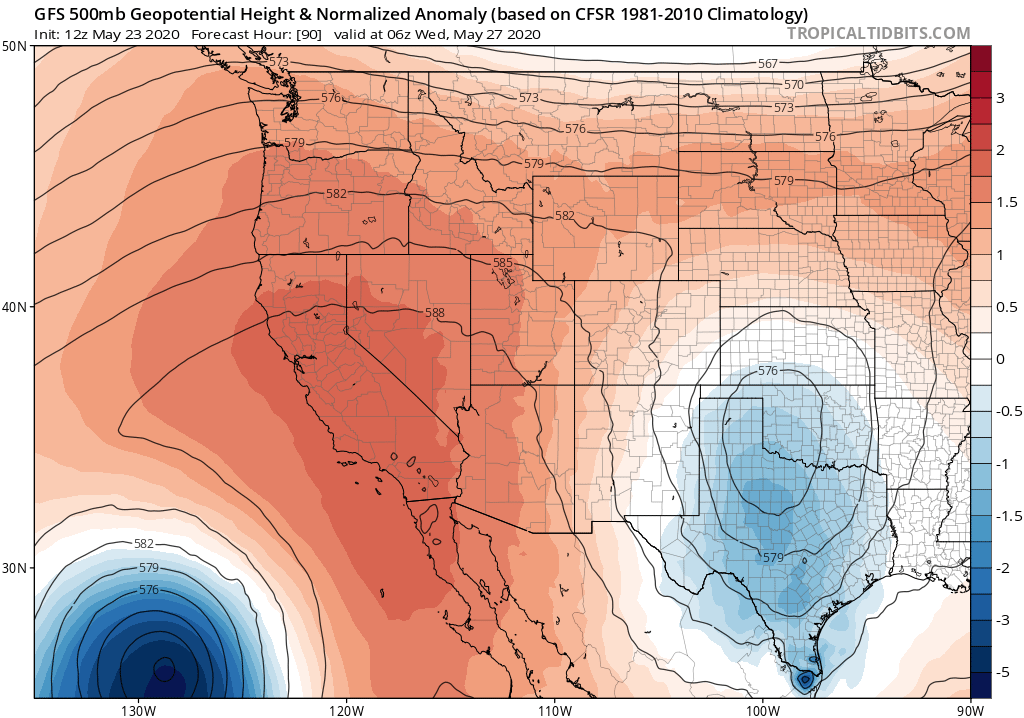
This upcoming heat event will last from Sunday through at least Thursday across most of California–which is pretty prolonged, especially for such an early season event. The event is also expected to steadily intensify through its duration–also a bit unusual for CA events. So, what’s causing this highly anomalous weather this week?
Well, it all has to do with atmospheric “blocking”–i.e., the disruption of the typical large-scale atmospheric flow by a nearly stationary atmospheric high pressure system. In this instance, the ridge is taking up residence right over California, and will initially take on a (tilted) “Rex” block configuration (i.e., a persistent high pressure system located just poleward of a persistent low pressure system). As the week progresses, this Rex block will transition to an “Omega” block configuration as the ridge remains quasi-stationary–anchored in place by a pair of low pressure systems to the southwest (over the Pacific) and southeast (over the interior Southwest/Texas). Both of these set-ups are very stable–and tend to be associated with persistent and/or extreme weather conditions. (The NWS Bay Area forecast discussions over the past 48 hours have had excellent, detailed descriptions of this).
Heat wave with a twist: NorCal (dry-ish?) thunderstorm risk?
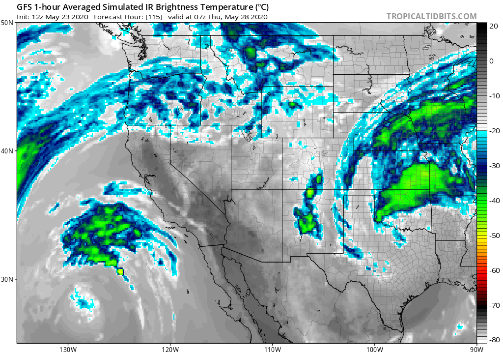
As if the extreme heat were not enough, the unusual nature of the Omega blocking pattern may ultimately result in some additional interesting weather later in the week. As the ridge axis shifts eastward over the interior West by next Thurs/Fri, the cut-off low pressure system offshore will slowly begin to move toward the central and northern California coast. As it does so, there will finally be relief from extreme heat (especially across coastal areas). But this will be a pretty deep low by late-May standards, and will be associated with somewhat cold air (aloft) as well as a region of persistent upper-level divergence (and mid-level upward motion) on the east side of the low. As a result, there will be a fair bit of mid-level atmospheric instability from about the SF Bay Area northward from late Thursday into Friday. This low will be pretty moisture-starved, but there will probably be just enough to allow for the development of isolated/scattered elevated convection (possibly more widespread across far NorCal). This means that at least isolated showers and thunderstorms may occur as far south as the Bay Area, with the potential for a more widespread lightning event further north. Given the antecedent hot airmass and limited low-level moisture, I think it’s possible that there could be some (relatively) dry thunderstorms across parts of NorCal during this period. I would expect these possible storm cells to be associated with at least some precip, but with precipitation accumulations expected to mostly stay below 0.1 inches–that would qualify as “dry lightning” by most fire weather definitions.
Given the unusually dry state of the vegetation across much of NorCal at the moment–and that record heat is expected to occur for 3-5 days immediately preceding this possible lightning event–there may be some risk of lightning-sparked wildfires by Friday/Saturday across NorCal. This would be quite an unusual situation to occur in spring–it’s actually more reminiscent of a late summer monsoonal and/or autumn pattern (widespread heat followed by a dry but unstable airmass associated with an offshore low moving inland). As with such set-ups, it’s going to be almost impossible to predict the spatial coverage and intensity of this elevated convection more than 24 hours in advance. For now, about the best I can say is that unless something changes significantly, I would expect some elevated convection and thunderstorms at some point Thurs-Sat across some portion of NorCal–possibly including some coastal/valley locations. I’ll continue to follow these events as they evolve on Twitter.
Heat reprieve early June, but still unusually warm?
Right now, the blocky North Pacific is pretty chaotic and will be hard to predict more than a week or so in advance. However, multi-model ensembles are suggesting that things will cool down significantly for at least a few days beginning next weekend. Thereafter, there is more uncertainty regarding what happens next–although it does look generally dry. There are some signs of increased odds of renewed heat by early June–but at the moment, that remains fairly speculative. Stay tuned.
Unusually intense and prolonged early-season heatwave developing across California Read More »