Hurricane Priscilla remnants to bring widespread Southwest rain/thunderstorms (including far SoCal); more widespread precipitation possible with colder NorCal system by mid-Oct
An very mild September across CA, but humidity & some unusual rainfall kept fire risk low
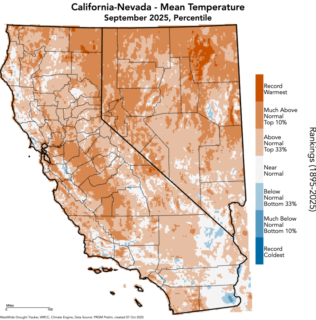
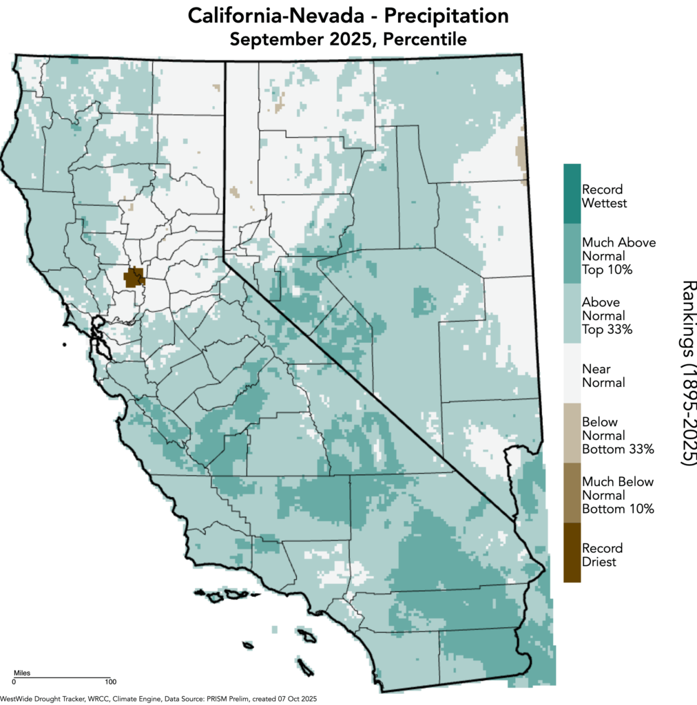
September 2025 was yet another “strange” weather month along the Pacific Coast. In California, multiple episodes of precipitation (and a fair bit of thunderstorm activity) brought wetter conditions to much of the state–particularly across central and southern California. Serious, even deadly flash flooding and debris flows occurred in the lower deserts of SE CA and the San Bernardino Mountains when remnant moisture and instability from Tropical Storm Mario produced locally torrential thunderstorm downpours; while rain elsewhere was (thankfully) much less dramatic, it was nonetheless unusual for September.
Temperature-wise, it was a very mild month nearly statewide. No widespread record heat occurred, but temperatures were for the most part consistently elevated relative to the long-term average (especially in the Central Valley). While statewide temperatures were in most cases lower than recent Septembers that featured sustained record-breaking heat, they generally ranked among the top 10-20% warmest of all September temperatures in the past ~130 years. Much of this warmth and mildness was linked to now highly anomalously warm near-shore ocean surface temperatures–part of a widespread and record-breaking heatwave that now stretches clear across the North Pacific from China and Japan to the U.S. Pacific coast (see below). These warm ocean temperatures also kept humidity higher than usual–increasing “apparent heat” indices.
One fortuitous effect of this occasionally showery weather, combined with the lack of strong offshore winds, was a lack of large fire activity nearly statewide. This was in considerable contrast with the Pacific Northwest, as well as parts of British Columbia, where highly unusual late-season heat and dryness allowed rare late-season forest fire activity to continue through the month and even into early October.
Another tropical remnant/offshore low pressure interaction will bring active/wet conditions to much of Southwest, including parts of SoCal
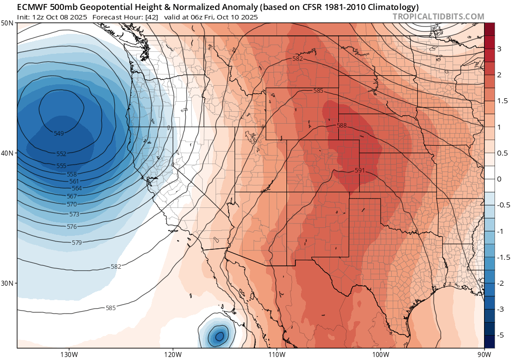
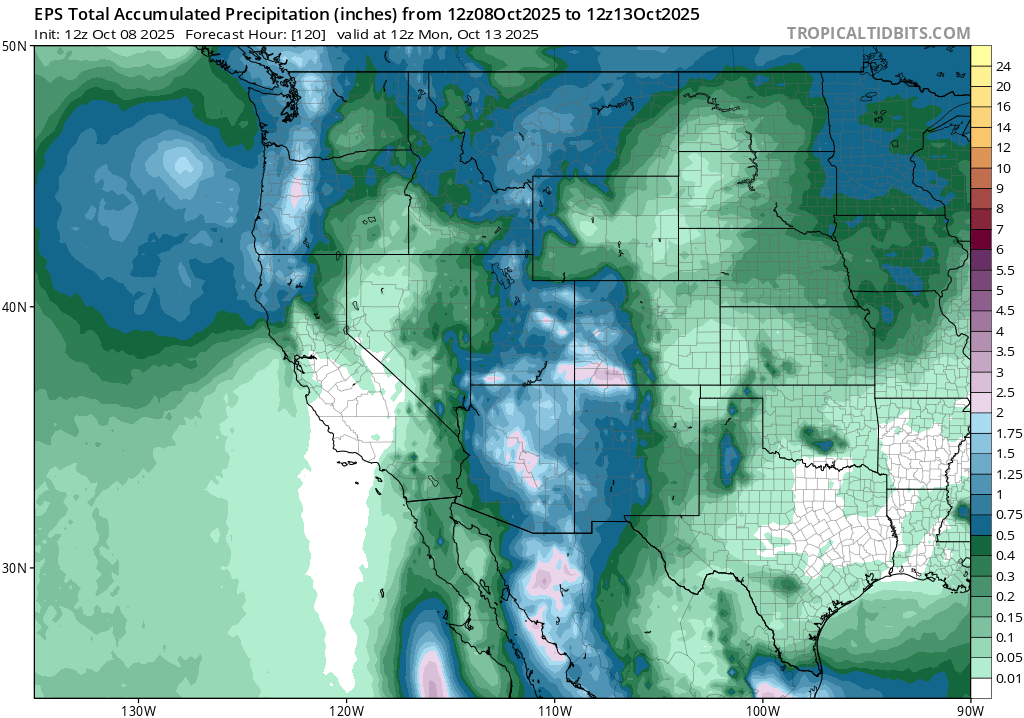
Continuing the theme of “active and unusual” weather California has seen in recent months, another notable period will begin tomorrow across SoCal before shifting toward NorCal by early next week. Over the next 24-48 hours, the remnants of now rapidly-weakening East Pacific Hurricane Priscilla will become entrained into southerly flow ahead of a large offshore low pressure system. This will allow Priscilla’s remnant circulation, along with abundant moisture and instability, to recurve in a northeastward direction over northern Baja California and into the lower deserts of SE CA and S AZ by Friday and Saturday. This will likely generate a fairly substantial swath of moderate to heavy rain over the lower Colorado Basin–the second or third such event in recent weeks. It will also have the potential to generate isolated to scattered, but locally very heavy, shower and thunderstorm downpours in the lower deserts of SE CA and perhaps also the eastern slopes of SoCal mountains. Some additional shower and isolated thunderstorm activity may also occur over coastal SoCal, mainly south of Los Angeles (and including San Diego), though the intensity and northward extent appears limited. There will probably be at least some risk of flash flooding in the lower desert portion of SoCal into the weekend, but especially eastward into Arizona (where some locations could see 2-3+ inches of rainfall).
The offshore low will also generate some NorCal showers in its own right, even absent any tropical moisture that far north. In fact, some isolated thunderstorms will be possible here too as relatively cold air aloft combines with unusually warm coastal SSTs to generate some surface-based instability. So both far SoCal (south of LA) and northwestern CA (mainly north of SF) will both see some precipitation over the next 3-4 days, as well as at least isolated thunderstorm activity. Areas in between, however, will probably stay dry during this period.
Mixed signals in medium term, but growing indications of more significant (maybe fire season-ending?) NorCal rain event
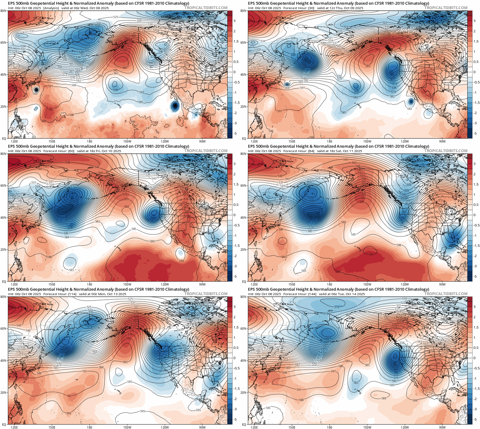
The active pattern now appears likely to continue past this weekend, however. There is still considerable uncertainty regarding the exact pattern evolution over the North Pacific basin next week–largely due to the disruption of the mean flow pattern by a recurving West Pacific typhoon. This is a classic October set-up for active NorCal weather conditions, but also for uncertain forecasts: re-curving typhoons can greatly amplify the jet stream and associated storm track at this time of year, and sometimes lead to high-amplitude wavetrains (ridge-trough patterns) that can lead to either exceptionally hot/dry/windy conditions or exceptionally cool/wet/windy conditions (depending on exactly where the ridges and troughs align). In this case, it’s looking increasingly likely that the persistent and seasonally anomalous trough/low will set up just northwest of California in an ideal position to bring a significant early-season rain event to northern and central CA early next week.
As noted, there is inherently high uncertainty during episodes like this involving injection of energy and moisture by recurving typhoons during autumn. The forecast could yet shift in a drier (or perhaps even wetter!) direction; at the moment, the ECMWF ensemble is much wetter than the GFS ensemble (for instance). However, the odds of what could be a “fire season ending” rain for most of NorCal, and perhaps parts of central CA, appear to be rising (though still remain low for SoCal). So this could ultimately be a helpfully timed low pressure system from a fire weather perspective.
North Pacific marine heatwave persists: what are the implications for the rest of autumn and winter?
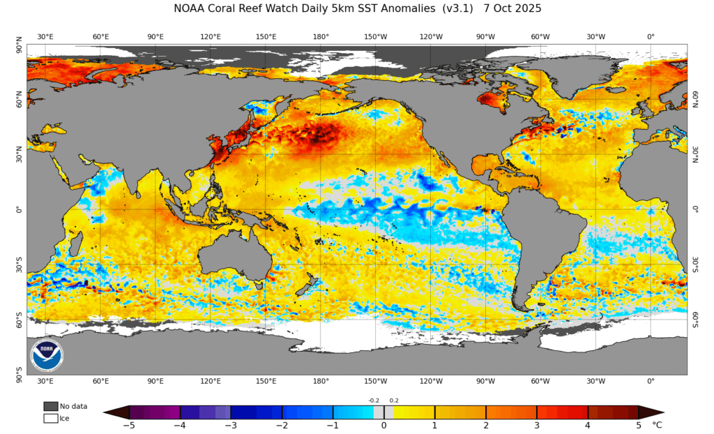
I’ve been talking about the remarkable, and (increasingly) record-breaking, pan-North Pacific marine heatwave for months now. First originating in the West Pacific and centered near the Kurishio Extension region in spring 2025, it has persisted for half a year in the west and now extends for thousands of miles clear across the ocean to the near-shore waters of California and the North American Pacific Coast. Some recent cooling (to near average temps) has occurred in the Gulf of Alaska, but temperatures along the CA/OR/WA coastlines remain far above average for the time of year (and this is also true along the entire storm track region from Japan to the U.S. West Coast).
What does this mean for the rest of autumn, and perhaps even the winter to come? Well, coupled ocean-atmosphere seasonal models suggest that much of this marine heatwave region will continue to be warmer than average for the next several months–at least through early winter. This includes the immediate CA/Pacific Coast zone. Simultaneously, a La Niña event of weak to moderate magnitude is expected to continue to develop and persist until the early winter months.
Altogether, this paints a picture of a North Pacific basin in which the north-to-south (meridional) temperature differential is among the weakest it has ever been in the modern record. In practice, the meridional SST gradient can influence the strength and position of the jet stream, with a weaker and northward-shifted gradient perhaps increasing the likelihood of a weaker than average and northward-shifted jet. However, these anomalously warm waters (for as long as they persist) will also allow for increased evaporation from the ocean surface and therefore probably increase the amount of water vapor in the lower atmosphere available for winter storms/atmospheric rivers to take advantage of if/when they occur. I think we’ve already been seeing the effects of this with the early-season systems this autumn, which have appeared to generate deep convective (i.e., thunderstorm) activity with relative ease (perhaps due to increased lower atmospheric instability). Thus, at least for the rest of fall and early winter, we will experience the effects of a North Pacific SST configuration that has rarely–if ever–been recorded: extremely warm extratropics across nearly the entire basin combined with cooler-than-average tropical waters.
Warmer than average conditions across California will probably prevail, overall, during autumn and early winter–though this likely does not mean “hot,” especially in the presence of increased surface moisture (and as we’ve seen in recent weeks). The storm track will be more likely to be northward shifted and weaker during the first part of the season, perhaps favoring drier conditions in SoCal. But whatever active periods do occur might produce quite substantial precipitation as storms take advantage of increased atmospheric water vapor that will likely be present. With those two potentially countervailing effects, it’s difficult to say how precipitation may play out over the next few months (but I suspect the PacNW and perhaps far NorCal will do pretty well). Central/SoCal will be favored to be drier than average, but even one or two “juicier than average” storms could change that.
Finally, I’d also note that the combination of La Niña potentially “punching above its weight” (due to the additive effect of very warm North Pacific SST), combined with a shift to a negative (easterly) QBO (Quasi-Biennial Oscillation) pattern in the stratosphere this winter, suggests that the latter half of winter could well look pretty different from the first half. La Niña plus negative QBO conditions tend to favor a weaker stratospheric polar vortex, which can lead to greater odds of a more amplified weather pattern over North America. While I think that’s probably enough acronym overload for today…I’ll talk a bit more about that in the weeks to come.
YouTube livestream: Today, October 8th, at 3pm Pacific Time!
Join me live to discuss the effects of Hurricane Priscilla in the Southwest, and also to hear new updates regarding developments on the federal weather and climate front.