Warm Thanksgiving ridge pattern will likely transition toward progressively wetter pattern around early Dec
Warm and dry pattern for the Thanksgiving holiday week

Last week brought a complex and hard-to-predict weather pattern to California: a large and slow-moving cut-off low pressure system took its time inching toward the coast, bringing irregularly spaced but sometimes heavy bursts of showers and scattered thunderstorms. After all was said and done, some areas saw very respectable rain totals in the multiple inches–but other spots were left, if not high and dry (since there was at least some light precip pretty much everywhere) frustratingly parched. This system was characterized by an unusually unstable airmass for California standards in November, and was associated with quite a bit of lightning–perhaps bolstered by unusually warm near-shore ocean temperatures, which remain comparatively balmy this week. That storm was followed by some notably strong Santa Ana and Diablo offshore winds over the weekend–but given the damp antecedent conditions and rising fuel moisture levels, there was no major wildfire activity.
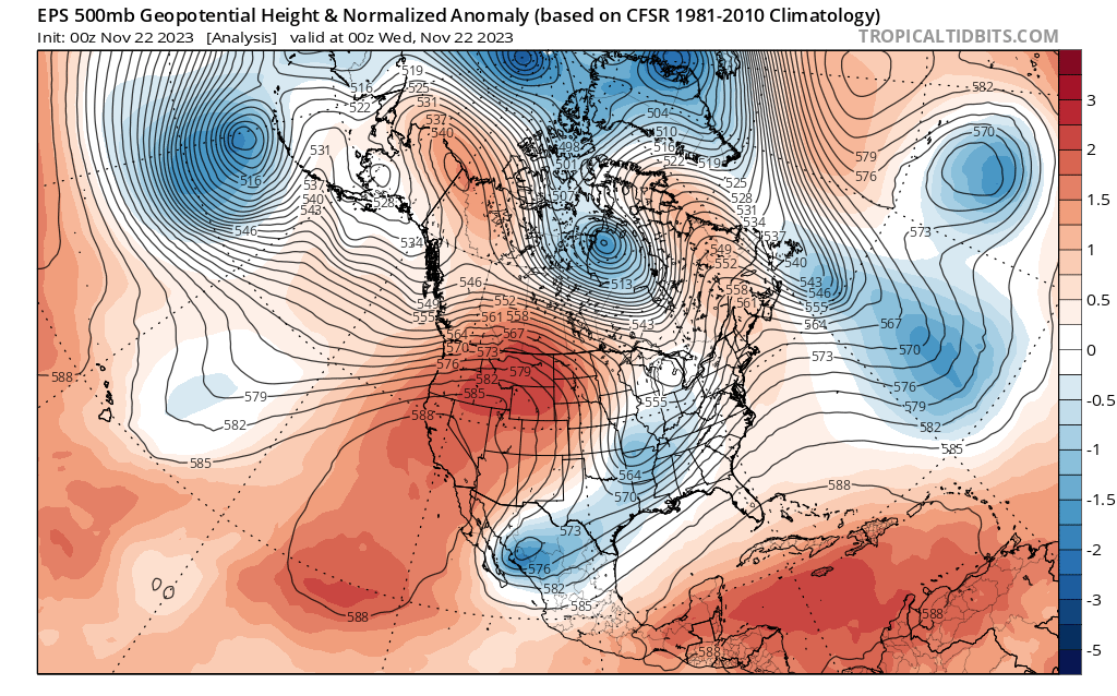
Balmily warm and dry conditions have been in place across California for several days now, and that general pattern is expected to continue through most of the holiday week. A 70+ degree Thanksgiving is likely across much of the Golden State, with relatively mild conditions even persisting at higher elevations. Though the strength of the strong ridge that has been producing unusually warm conditions along the entire west coast of the U.S. this week will fade after Thursday, with daytime highs slowly falling, relatively mild daytime temperatures though with cool overnights will continue for the next 7-10 days across most of the state as a relatively dry airmass remains over the region. As you might expect during a progressive but primarily “ridgey” pattern, little or no precipitation is likely to fall anywhere in California for the next 7-10 days.
Early signs of a transition toward much wetter and more pattern in early Dec

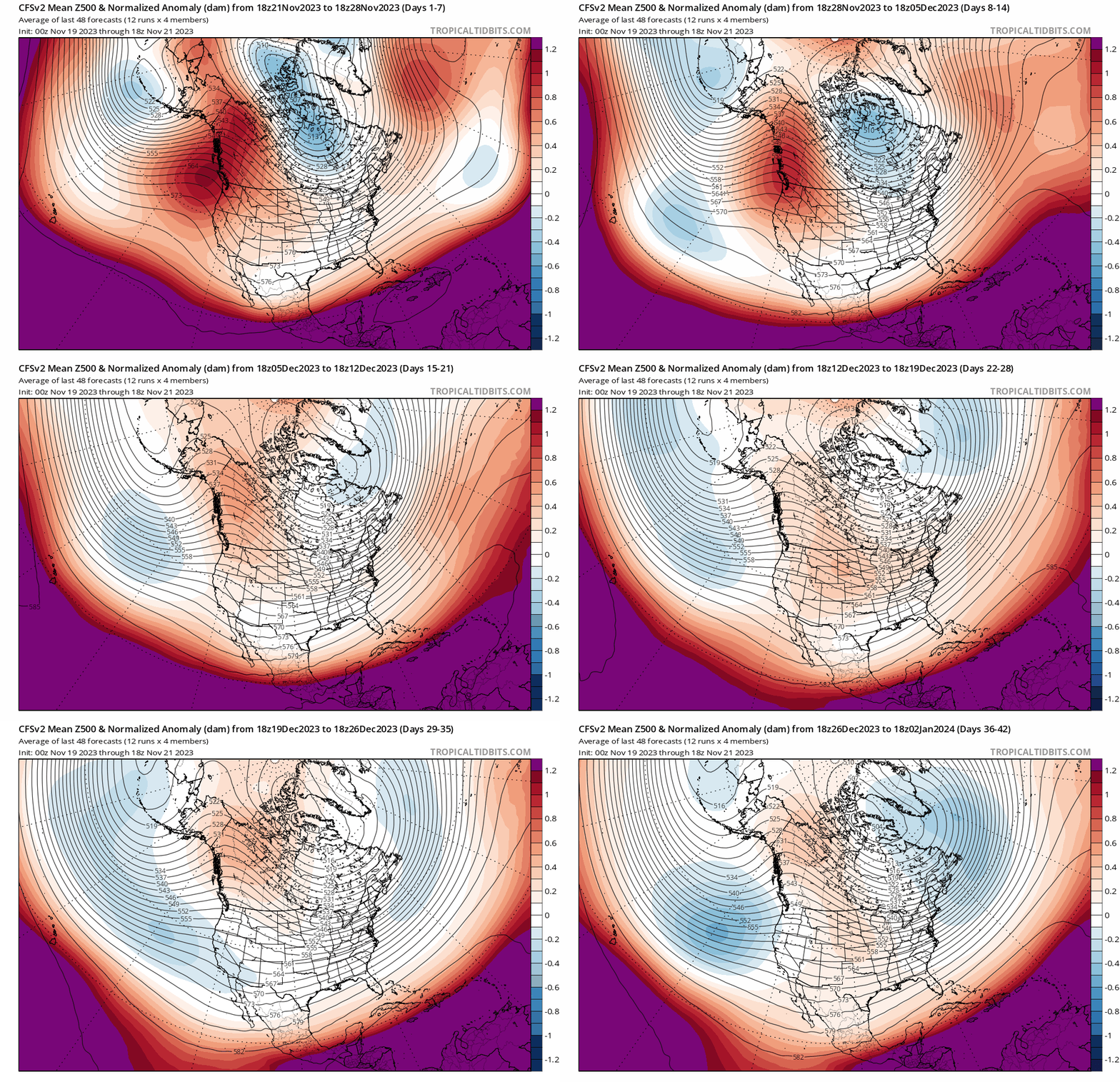
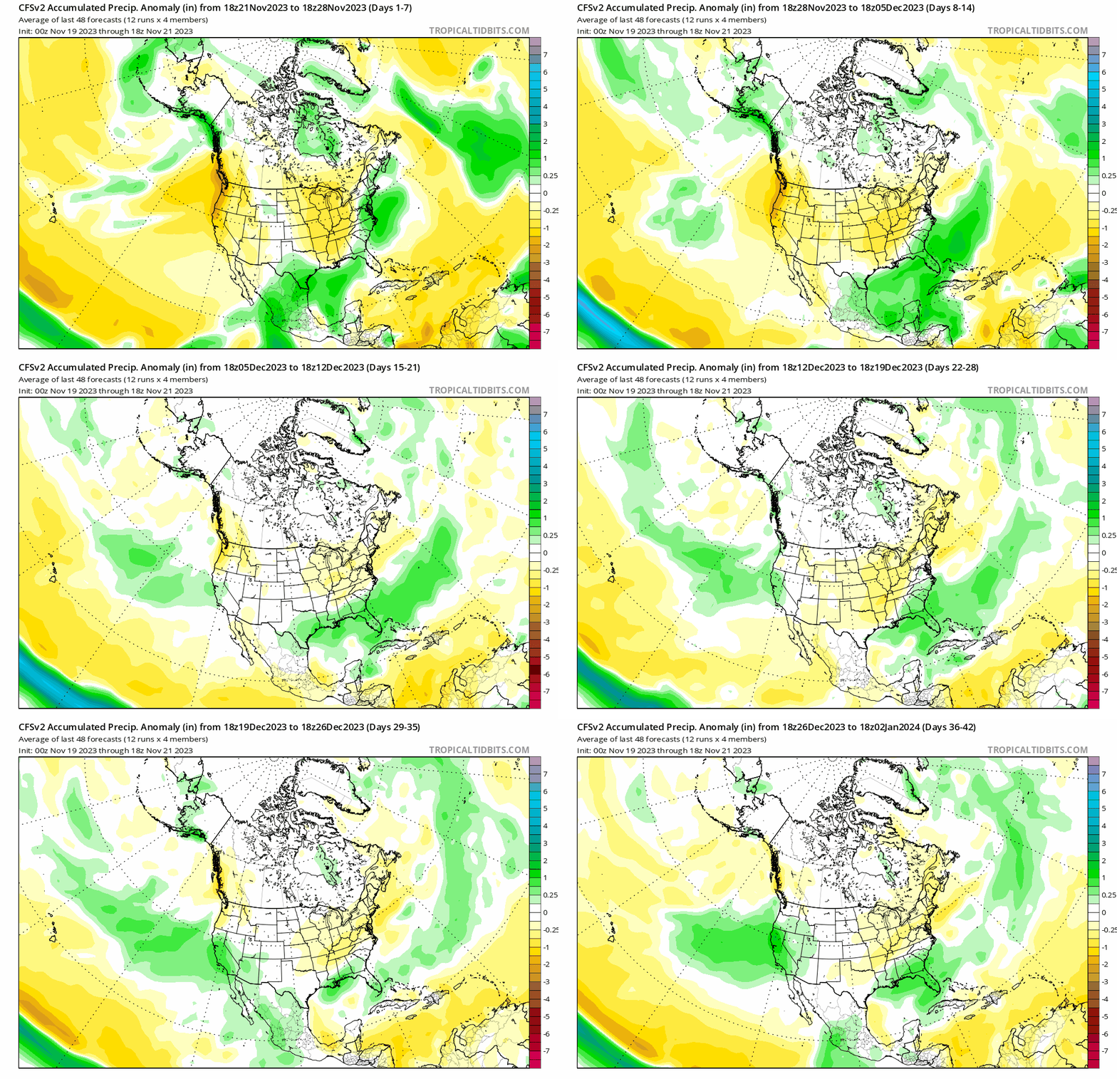
There are, however, growing signs of a larger scale and likely more sustained transition toward a wetter, more active pattern by early to mid December. Long-range traditional weather ensembles are suggesting that this trend will first begin to emerge around 10 days from now, and subseasonal ensembles are currently suggesting a continued escalation of this wetter pattern through December as the broader setup becomes increasingly favorable for the “storm door” to open on a more consistent basis.
In the short term, this possible emergence of a wetter pattern may be partly linked to the eastward progression of an active Madden-Julian Oscillation (MJO) cycle that has the potential to “jump start” the transition. But as we head later into December and into January, I’d expect the seasonal-scale influence of an already quite strong and still strengthening El Niño event to emerge more strongly and to potentially become a major influence on California hydroclimate for most of the rest of the winter.

As I’ve noted many times in the past: when there is a substantial El Niño (EN) event, the atmospheric and oceanic “base state” usually doesn’t reach a point favorable for the Rossby wave perturbations generated by displaced tropical thunderstorm activity (deep convection) to substantially or consistently alter the jet stream over the North Pacific until mid-winter–usually late Dec or Jan. This is why there’s a pretty weak correlation between even strong EN events and autumn precipitation across most of California–it’s just too early in the season. But this year, it looks like subseasonal forcing (from the MJO) will potentially accelerate that process just prior to the time of year when EN-related seasonal influences might be getting their act together.
What does all of this mean, in practical terms? As always, both the MJO and EN offer a tilt in the odds toward certain outcomes rather than a guarantee of any particular conditions in California. But at this time, it does seem that things are lining up for the pattern to become progressively more active and wetter in California starting around early to mid December–and seasonal predictions continue to hint at a relatively high likelihood of wetter than average conditions then persisting through the rest of winter for at least central and southern CA, and perhaps parts of NorCal as well.
Eastern tropical Pacific approaches “Super El Niño ” territory as warming continues

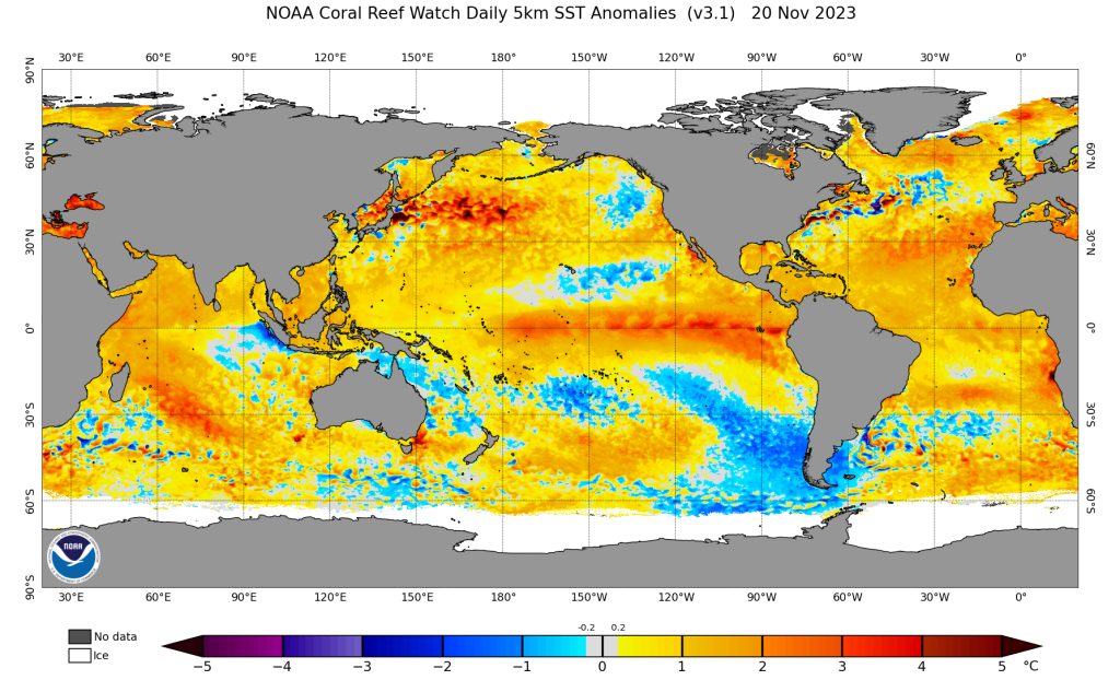
And how is El Niño going at the moment? Well, it has reached its strongest/warmest point so far in this cycle–Nino 3.4 SST anomalies are now in excess of 2C (3.6F). If these kind of values are sustained for a couple of months–and most seasonal predictive models suggest there’s a good chance they will be–this event would ultimately be classed as a historically rare “Super” El Niño event. Whether or not that title is actually achieved, it’s clear this event is quite a strong one and is increasingly having a classic EN-like influence on the global atmosphere (despite a slow start). A strong westerly wind burst in recent days will likely help maintain existing warm anomalies or even allow larger ones to surface soon–so this event is almost certainly going to stick around through all of winter.
Also striking, as you can clearly see in the ocean surface temperature anomaly map above, are unusually warm ocean temperatures in most of the global ocean basins, including most of the North Pacific and also along the immediate California coast. It’s no surprise that the Earth, which is about 71% covered by water, continues to be be record warm this month (as it has been for much of 2023 thus far).
Publisher discount on my extreme weather and climate calendar!
From today through 11/29, the publisher of my 2024 extreme weather and climate calendar is offering a 25% discount (use coupon code “CYBER23″). You can check it out here!
Announcing: New ad-free membership tier on Weather West!
Since so many folks have asked over the years, and I’ve been looking for new ways to support the site, I’ve finally set up a (100% optional) advertisement-free membership tier on Weather West! If you sign up, you’ll be supporting my science communication efforts (including this website) but will also receive ad-free access to weatherwest.com. The cost? A modest $3.99/month. If you’re interested, you can sign up here!
A note to all who may be concerned: This new paid membership tier is entirely optional, and does not grant access to any new site content (it only removes the advertisements). So everyone will continue to be able to freely access all past and future posts!
A further note to those who sign up: You will need to be logged into weatherwest.com itself (the WordPress site) for these ads to go away. This is separate from the Disqus login needed to participate in the comments section. If for some reason you are logged into weatherwest.com and still seeing ads–or have any other problems–please let me know via the Contact page!