Increasingly extreme autumn wildfire conditions in California due to climate change
Note: This special Weather West article focuses on new peer-reviewed scientific research, led by Michael Goss, that my colleagues and I recently published in Environmental Research Letters. I originally intended to publish this post earlier in the year to coincide with our paper release, but due to the unprecedented and ongoing California wildfire crisis during Aug-Sep 2020 I decided to wait until a relatively calmer window.
California is no stranger to wildfire—but the stakes are increasing
Wildfire has been a part of the landscape in the region encompassed by present-day California since…well, time immemorial. Fire is a natural process, and many ecosystems depend on fire of some frequency and intensity for their health and long-term regeneration (although natural fire frequency and intensity varies widely across different ecoregions and vegetation types). Indeed, the indigenous peoples of California have actively managed fire for over 10,000 years—so even human interaction with California wildfire is nothing new.
But several hundred years ago, California was home to fewer than half a million people. Today, more than 40 million live in the Golden State—millions of whom live in “high hazard” fire risk zones. At the same time that many California communities have expanded into potential harm’s way in the wildland urban interface, the unfortunate legacy of 20th century “total fire suppression” policies has allowed forests to become unnaturally overcrowded in many places, increasing potential flammability. (This is, in fact, a significant problem throughout heavily forested parts of the American West. But, importantly, it’s also largely essentially irrelevant with respect to the relatively large subset of California wildfires that occur outside of its forested regions–such as in coastal chaparral or oak woodland regimes.)
Both of these influences—the expansion of communities into the wildlands and historical fire suppression increasing forest fuel loads—have clearly increased the risk of large and destructive California wildfires. But these two important factors, on their own, don’t tell the whole story. California’s warming climate is another critical piece of the increasingly complex puzzle, and is acting as a “wildfire threat multiplier” spanning geographies and fire regimes. But how, exactly, can we isolate and quantify the climate change component of California’s rapidly escalating wildfire problem? That was the question we set out to answer in the study I discuss in this blog post.
The context: devastating autumn firestorms in 2017 and 2018
The events of autumn 2017 and 2018 are deeply etched in the memory of many Californians (although some of these memories have already been eclipsed by even more recent and widespread fire catastrophes in 2020). The Camp Fire–which destroyed most of the town of Paradise, CA in the northern Sierra Nevada foothills–and the Woolsey Fire in the Santa Monica Mountains in coastal southern California together claimed around 90 lives and 20,000 structures as they burned simultaneously on November 8, 2018. Just one year earlier, on October 8 2017, the Tubbs Fire in Santa Rosa and other nearby conflagrations claimed over 25 lives and 6,000 structures. These were—and remain—stunning and tragic wildfire losses on a scale that had not previously been experienced in California.
The ambient weather and climate conditions preceding each of these fires were strikingly similar: record vegetation dryness, following extremely warm conditions in the weeks and months preceding the fires, coincided with a strong offshore wind event. Such offshore wind events are not uncommon in California during the autumn, and indeed have historically been associated with a large majority of the region’s fastest-moving and most destructive wildfires historically. But what was different this time, compared to previous major wind-driven autumn fires over the past century, was the extreme and in many cases record-breaking level of vegetation dryness leading up to the wind events. (It is worth noting that a somewhat similar set of conditions has once again led to an unprecedented wildfire crisis in California as of this writing—especially with respect to the fast-spreading Bear/North Complex fire in Butte County, which has thus far been the deadliest of the fires so far during the 2020 fire siege).
The horrifying details of the California wildfire situation over these past few years—particularly in autumn—thus motivated us to formally and scientifically address the question that was on everyone’s mind: is climate change contributing to California’s escalating wildfire crisis?
Extreme autumn wildfire conditions have more than doubled

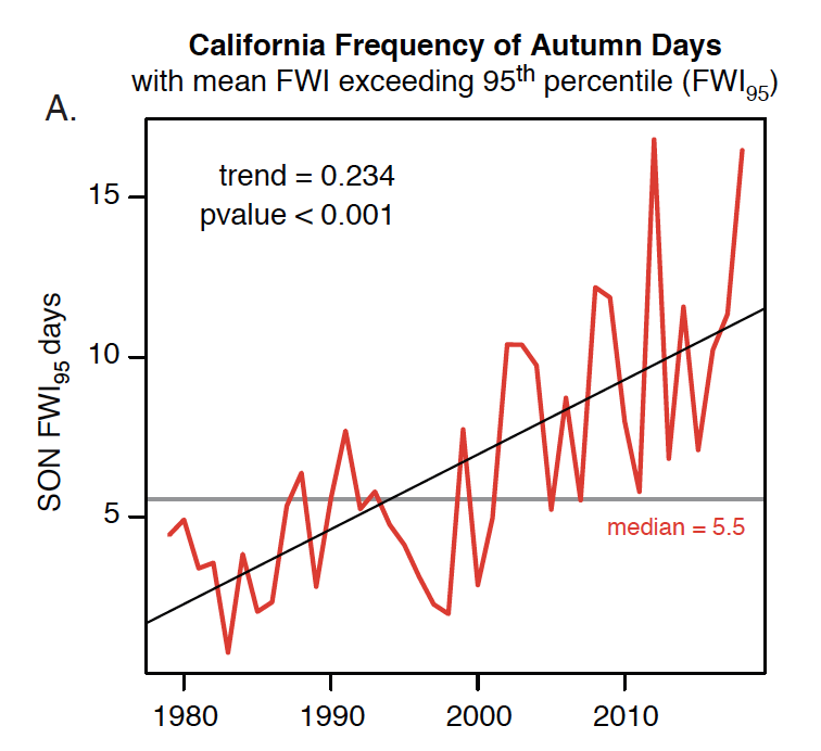
As it turns out, the short answer is…yes: we found that climate change has already more than doubled the frequency of extreme autumn wildfire conditions in California over the past ~40 years. This finding is based on observed changes in the frequency of occurrence of autumn days exceeding the 95th percentile of the historical Fire Weather Index (FWI). The FWI gives a quantitative estimate of the severity of wildfire risk using a multivariate suite of meteorological data (including temperature, humidity, wind speed, solar radiation, and vegetation “fuel moisture” (which itself incorporates antecedent weather/climate information)). Overall, mean September-November FWI in California increased by about 20% between 1980 and 2018—a trend that was distributed fairly uniformly across the state, including both coastal and interior regions in the north and south. We further found that the occurrence of extreme FWI days was strongly associated with days on which large wildfires occurred—strengthening the link between increasing FWI and the severity of actual fire conditions on the ground.
Hotter temperatures and reduced autumn precipitation

This large increase in both mean and extreme fire weather conditions was driven by a combination of warming temperature (around +1.6 F) and decreased precipitation (around -30%) during autumn. These observed trends in temperature and precipitation, as with FWI, occurred across virtually all of California over the study period. The effect of warming is almost exactly as you’d expect—warmer temperatures equal higher fire risk—but I discuss why the magnitude of that effect is larger than most folks might realize in the next section. The role of decreased autumn precipitation is a bit more complicated, though, and is worth some additional consideration.
Most of California sees the vast majority of its seasonal precipitation during its core rainy season months in winter (i.e., December-March). The first widespread soaking rainfall historically arrived in northern California in October or November, and in southern California slightly later–during November or December. As a result, autumn precipitation is (even in the best of years) typically only a modest fraction of what falls during the core rainy season months. But as many Californians may intuitively understand, autumn precipitation is of outsized importance from a wildfire perspective. This is because the onset of “fire season-ending rains” typically occurs sometime during the fall, and once widespread soaking precipitation arrives, fire season is effectively over. From a wildfire risk perspective, the earlier this occurs, the better—since autumn also happens to be the season during which desiccating “offshore winds” begin to occur. These very dry, sometimes violent downsloping wind events—known as the Santa Ana winds in southern California and the Diablo winds around the San Francisco Bay Area—typically begin around late September before peaking in late autumn or early winter. If the autumn rains are minimal, or are delayed, the temporal overlap between “summer-like” vegetation dryness and offshore wind season increases—a dangerous combination that can lead to extremely high FWI and subsequent wildfire risk.
This potentially explosive combination of increasingly warm and dry autumns is something we’ve been seeing more often in recent decades, and it has driven a pretty dramatic increase in extreme fire weather days between September and November—just as we saw in autumn 2017/2018 (and as now may be occurring again during autumn 2020). And this is all happening without a clear increase in the offshore winds themselves! The key climate connection–as I discuss in greater detail below–is through warming, drying, and the increasing aridity of California’s vegetation.
Climate change is cause of observed increase in extreme fire weather

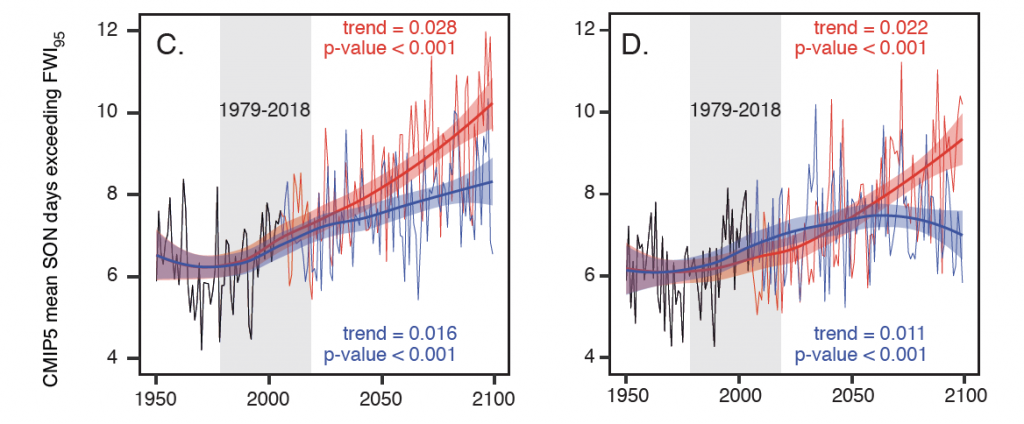
Historical data using real-world observations clearly shows that autumn warming and drying have increased extreme fire weather conditions in California over the past 40 years. But are these observed trends directly attributable to long-term climate change caused by human activities? That was the next question we set out to answer in our study using a suite of climate model simulations, which allow us to assess whether the observed increase in extreme autumn fire weather conditions in California is consistent with what would have been predicted. And the answer, once again, is yes: the observed increase in extreme fire weather conditions in California during autumn over the past few decades is exactly what climate models suggest should have happened due to human-caused climate change over the same period.
Key climate-wildfire link is through vegetation aridity
One thing that has become quite clear in recent years, both in our own work and in the increasingly extensive body of scientific inquiry by other researchers, is that the primary link between climate change and wildfire risk is through vegetation aridity. All else being equal, when vegetation of any type loses moisture and becomes drier, it burns more readily and more intensely. It’s not simply a question of whether vegetation is “dry enough to burn”—in California during the summer and autumn months, there’s no question that it usually is. Instead, it is literally a matter of degrees, since the magnitude of vegetation dryness has long been known to strongly modulate the characteristics of wildfire—and increasingly dry vegetation is associated with hotter, faster-burning, and more extremely “behaving” fires. As fire intensity, severity, and size increases with vegetation aridity, these fires become more dangerous to humans and more detrimental to ecosystems.
How, exactly, does climate change increase vegetation aridity? Well, the basic effect is actually fairly intuitive—warmer air means more evaporation, which means less water available to plants in the absence of a large increase in precipitation to close the water balance. But the details are pretty interesting, if you bear with me for a moment.
Rising temperatures increase what’s known as the “vapor pressure deficit” (VPD). The VPD is essentially a measure of the propensity for the atmosphere to act as a giant sponge and to “demand” water, via evaporation and/or transpiration, from the land surface and from plants. VPD is defined as the difference (in absolute terms) between how much water vapor could be in the atmosphere (i.e., the “saturation vapor pressure”) and how much water is actually in the atmosphere at a particular point in time. Because the saturation vapor pressure increases exponentially for linear increases in temperature, the VPD can increase quite quickly as temperatures rise—even if the relative humidity stays the same! The higher the VPD, the greater the degree of “atmospheric thirstiness”—which dries out both living and dead vegetation that acts as wildfire fuel. (Robinson Meyer, in his recent piece, includes a great overview of VPD in the context of wildfire and climate change).
Theoretical, model-derived, and real-world observational evidence all agree that the VPD is increasing in California in a warming climate—and that this is directly related to the surge in extremely large and intense wildfires. This is unfortunately being borne out in real time: the observed VPD reached record high levels in the days leading up to the unprecedented summer/autumn 2020 wildfire siege in California.
What does the future hold? More warming, and further increases in wildfire risk

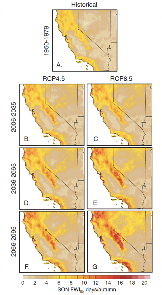
In short: we find that the greater the magnitude of global warming, the greater the degree of increased wildfire risk in California. In this study, we considered two possible future warming trajectories: one roughly approximating a world in which there is strict adherence to the 2016 Paris Agreement emissions targets and one outlining a “high emissions” future where global carbon emissions continue to increase rapidly and/or strong carbon cycle feedbacks occur. (For perspective, we’re currently on a path somewhere in between these two trajectories.) In both scenarios, the occurrence of extreme autumn fire weather conditions continues to increase for much of the 21st century—but at a substantially greater rate in the “high warming scenario.” In some fire risk hotspots in the Sierra Nevada and in the foothills ringing the Central Valley, we project a future increase that is anywhere from 50-150% above the historical 20th century baseline risk. Other areas—especially places closer to the coast—see smaller, though still substantial, increases in extreme autumn fire risk. (It’s also worth noting that the recent observed trend in extreme fire weather conditions over the past several decades has been even faster than climate models had suggested for the same period—so it is possible that current simulations may yet be underestimating future climate-linked wildfire risk.)
One thing that was particularly striking to me and other co-authors was the spatial ubiquity of these projected future wildfire risk increases across California—they appear to transcend geographies, ecosystems, and fire regimes. As such, this represents an even stronger statement regarding climate change and California wildfire risk than previous studies—which found a strong influence primarily in forested regions. On the other hand: an important caveat is that our study does not account for changes in the vegetation distribution itself—and previous work has shown that substantial climate-fire-vegetation feedbacks may emerge in the coming years that could either mitigate (or amplify) these climate-caused trends (depending on the local context). Needless to say, there will be much more research to come given the magnitude of the changes we’ve already observed, and those still to come.
What can be done? My personal perspective on global, community, and landscape-scale interventions
As much as we all wish there was a “silver bullet” solution to the rapidly escalating wildfire crisis in California and beyond, all available evidence suggests that there’s no simple way out. Wildfire is an inherently complex biogeochemical process, and there is no singular reason for the worsening crisis. It’s not just climate change, nor simply the unfortunate legacy of 20th century forest management, nor only the continued expansion into the wildland urban interface—it really is all of these things together, all at once.
For this reason, it makes sense to tackle each part of the problem separately, and in parallel. Increasing wildfire risk is only one of innumerably many reasons why we urgently need to halt global warming by eventually bringing our collective net carbon emission to near zero—but this will take a truly global effort, and is not something that’s going to happen overnight. Regardless of our future carbon emission trajectory, there is going to be additional global warming beyond what we’ve already experienced—so that component of wildfire risk is almost certainly going to get worse before it gets better. Over the next 10-20 years, at least, we’re are going to have to learn to live with continually increasing climate-contributed wildfire risk.
But the other two wildfire risk amplifiers—the legacy of total fire suppression and the increased vulnerability of populated areas to fires—are both issues that can potentially be addressed at the individual, local, and state level. There is already much ongoing discussion regarding the need to embrace managed and/or prescribed “good fire” on a much larger scale than currently implemented to help reduce wildfire fuel loads and improve forest health. Various entities at the local, state, and tribal nation level are working to put these plans into action in the next few years—although a complicating factor remains the fact that most forest lands in the American West are either privately or federally owned.
Much can also be done to improve the resilience of communities as well as individual structures to wildfire hazards. While the oft-promoted notion of “defensible space” is a good place to start, recent evidence suggests that other interventions are even more effective—including fire-resilient building materials and methods. At larger scales, communities can be designed to better resist fire (by incorporating greenbelts or fuel-reduction corridors, for example). Improved evacuation planning and communications infrastructure can make worst-case scenario firestorms less deadly by making it easier to leave affected areas in a safe and timely manner. And there has also been progress toward reducing high-risk wildfire ignitions during extreme wind events—via “Public Safety Power Shut-Offs” by electrical utilities—although such interventions remain highly disruptive, societally inequitable, and probably unsustainable in the long run due to our warming climate.
In the end, if we want to make meaningful progress toward stemming the exponential tide of wildfire catastrophes in California and the rest of the West, we’re going to have to take an “all of the above” approach. Some of the interventions mentioned above are essentially short-term stopgap measures; other could form the basis of a more sustainable long-term approach. I think one thing on which we can all agree, though, is that the status quo is definitely not working—and that we urgently need to have a serious conversation regarding how to move forward.
How is this article different from typical Weather West blog posts?
This special Weather West article focuses on peer-reviewed scientific research that my colleagues and I recently published in Environmental Research Letters, and also discusses peer-reviewed work by other scientists. This means that the content of this piece is based upon findings from formal scientific investigations by teams of researchers, which contrasts with more typical Weather West posts that are primarily based upon my own informal thoughts and analysis. I would like to thank my co-authors in this work—Michael Goss, Ali Sarhadi, Crystal Kolden, John Abatzoglou, Park Williams, and Noah Diffenbaugh—for their sustained efforts in bringing these projects to completion. Support for my contribution to this research was provided through a partnership between UCLA’s Institute of the Environment and Sustainability, the Capacity Center for Climate and Weather Extremes at the National Center for Atmospheric Research, and The Nature Conservancy of California.
A fully open-access version of this paper (freely accessible to all!) can be viewed here (Goss et al. 2020).
Citation
Goss, M., Swain, D.L., Sarhadi, A., Kolden, C.A., Abatzoglou, J.T., Williams, A.P., and N.S. Diffenbaugh. Climate change is increasing the risk of extreme autumn wildfire conditions across California. 15 (9), 094016, doi: 10.1088/1748-9326/ab83a7, 2020.
Increasingly extreme autumn wildfire conditions in California due to climate change Read More »