Yet another month of CA record heat in Oct
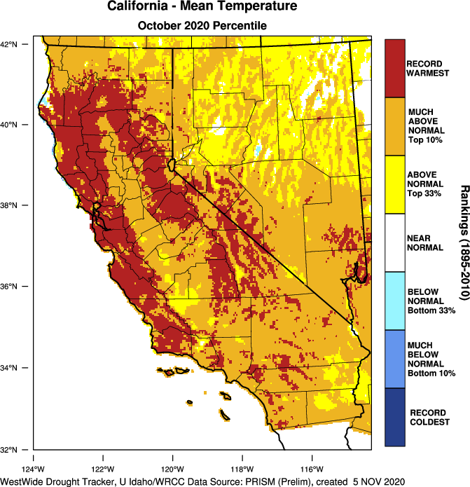
October brought another month of seemingly unending heat and extreme wildfire risk in California. August 2020 was the hottest August on record in California; September 2020 was the hottest September on record; and preliminary data suggests that October 2020, too, was the hottest October on record in the region. 60-day cumulative precipitation–which was actually very close to zero in most places–was the lowest on record for any Sep-Oct period on record for much of California and western Nevada.
Extreme wildfire risk continued through the month, and was bolstered by one exceptionally strong offshore wind event. Despite the astronomical level of risk, however, NorCal ultimately fared pretty well during this event through what I can really only attribute to a combination of good luck and (perhaps) successfully implemented Public Safety Power Shut-offs. (Despite being very problematic for a variety of reasons, these most likely did prevent at least a handful of dangerous fires in the urban interface). Somewhat miraculously, no major large fires were observed in NorCal.
SoCal did see several large and dangerous wildfires (especially in Orange County) during this wind event, but given the record dryness level of vegetation and the extremity of the observed winds–things still turned out less bad than they could have been.
Whew.
Cold storm–and (partial) fire season relief–arrives tomorrow
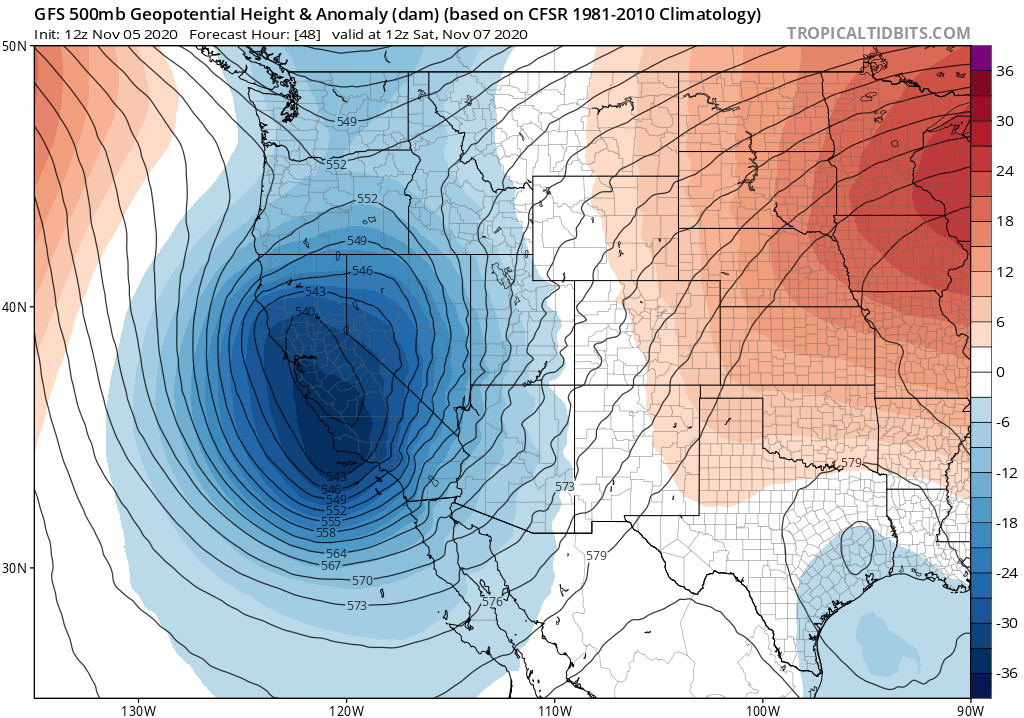
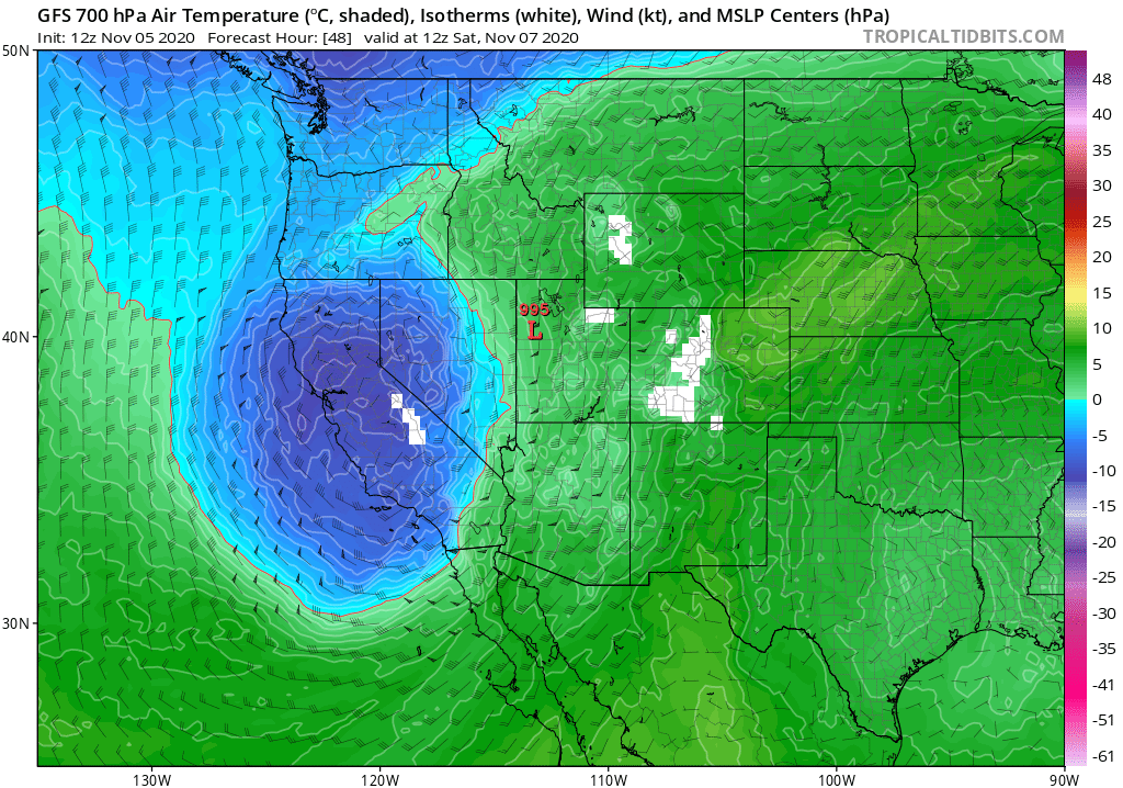
I finally have some genuinely good news to report: after a summer of record heat and horrifying wildfires, colder temperatures and moisture are finally on the way. A cold low pressure system will slide southeastward along the California coast beginning Friday into the weekend–bringing a dramatic shift to much colder temperatures, windy conditions, and (in many places) the first measurable precipitation of the season.
This system will *not* be a moist atmospheric river-type storm. Instead, this low will bring cold and somewhat dry but also pretty unstable air into California. This will not favor widespread stratiform precipitation, but instead scattered to numerous convective showers. Measurable precipitation is *possible* just about anywhere in the state, but will likely be most widespread and substantial 1) in the Sierra Nevada, where the first significant accumulating snowfall of the season is likely, and 2) along the immediate coast, especially in far NorCal and far SoCal. In these regions, a few tenths and up to a half inch or so of liquid equivalent is possible–which is not a tremendous amount, but will do wonders to tamp down fire risk. Precipitation is less certain and will certainly be less substantial over parts of the interior SF Bay Area and Central Valley–where scattered showers are still likely, but may leave some areas dry.
Some isolated thunderstorms are also possible just about anywhere in this cold, unstable airmass–but I’m not really concerned regarding dry lightning given the broader pattern.
One possible risk will be the combination of strong winds and still extremely dry vegetation in areas that do not see precipitation with this event (i.e., parts of the Central Valley foothills and interior SF Bay Area). Although relative humidity will be pretty high and temperatures cool, strong winds associated with the (partially dry) cold frontal passage could still create a window of localized extreme fire weather conditions. While I don’t expect widespread problems, there will still be the potential for some fast-spreading fires under these conditions where precipitation does not occur or does not occur until the post-frontal shower regime.
Later this weekend, a weaker disturbance will drop down the backside of the West Coast trough, bringing a renewed chance for additional coastal and mountain showers (though the Central Valley might once again be left pretty dry). All in all, this may be fire-season dampening precipitation in the Sierra Nevada and along the immediate coast, though probably not season-ending anywhere. However…
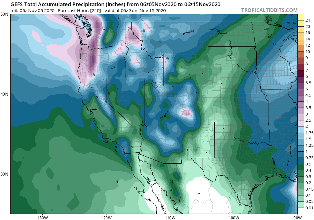
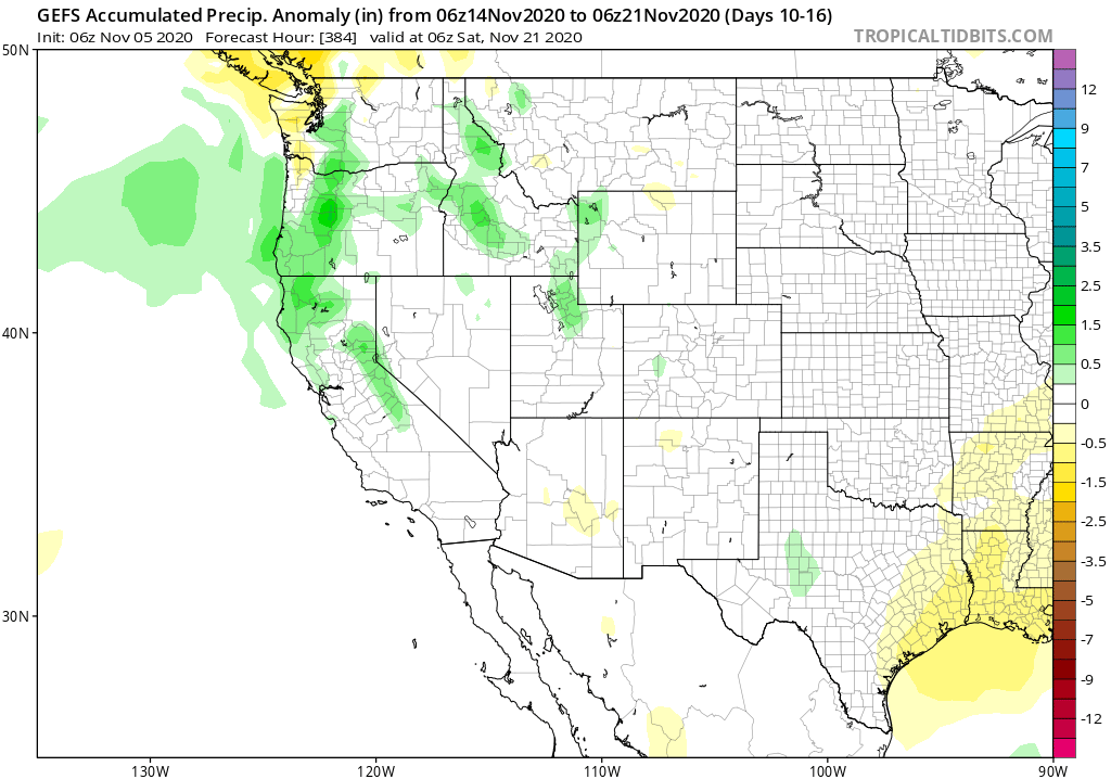
More widespread precip heading toward mid-Nov?
There is more good news. Right now, multi-model ensembles are pretty strongly suggesting at least a 1 week period of more widespread precipitation across most or all of California by mid-November. It’s interesting to note that the sub-seasonal forecasts have been consistently showing this development for several weeks, and now seems to be showing up in the standard ECMWF/GFS ensembles during Week 2. If this happens, as appears increasingly likely, the prospect for widespread, fire-season ending precipitation by Nov 15-20 looks pretty solid. That is still quite late, of course, relative to almost any other season in modern California history–but I think at this point just about everyone will be quite pleased that end of Fire Season 2020 may finally be on the horizon.
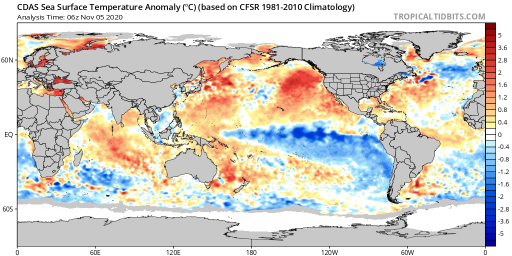
Strong La Niña still looms large
A very impressive La Niña event has now developed in the tropical Pacific Ocean–currently at moderate strength, but this event may ultimately become quite strong. Also striking is the historically unusual ocean temperature signature in the Pacific–with much cooler than usual waters in the eastern tropics but far above average waters…nearly everywhere else. Right now, seasonal predictions continue to point to a substantially elevated risk of a dryer-than-average winter to come, especially across the southern 2/3 of CA and largely on account of this strong La Niña event–but I’ll have more to say on that front in future posts. For now: enjoy the pattern change!
Discover more from Weather West
Subscribe to get the latest posts sent to your email.