Still no relief in California: bone dry conditions persist
.This section will be very short: it still hasn’t rained. For the most part, it has still been warmer than average since the last blog update. Vegetation remains at peak summer-like dryness–which means that potential wildfire fuel is now approaching or exceeding record low moisture levels for this point in that calendar year.
Very strong offshore wind event expected Sun/Mon
Much of northern California has been under Red Flag Warnings this week due to very low humidities and occasional light to moderate offshore winds. Fire risk will remain high, but not extremely so, over the next 48 hours as this pattern persists.
However, a dramatically stronger and more widespread offshore wind event now appears likely beginning late Sunday and continuing into Monday–which will likely lead to a period of very dangerous wildfire risk. In fact, this wind event is poised to become the strongest of the season so far (by a wide margin) and will likely approach the magnitude of the extreme autumn wind events in 2019 and 2017. Given that vegetation is now at or near record dryness levels–much as it was prior to the North Bay firestorm in October 2017–this is a very concerning forecast.
Why are such strong offshore winds expected? Well, it’s essentially a classic weather set-up: an anomalously strong/cold low pressure system will sink southward over the Great Basin and Rocky Mountains this weekend–generating a strong surface pressure gradient and driving very strong low-level winds across northern and central California. These strong winds will be funneled through the valleys along the Sierra Nevada western slopes, warming and accelerating as they do so. In the Bay Area, a similar process will occur as air flows east to west over the coastal mountains and downward toward sea level nearer the coast. In addition to the pre-existing very dry airmass, this downslope flow will further dry the air to the point that there will be virtually zero moisture in the entire atmospheric column–the ECMWF is suggesting precipitable water approaching zero (<0.05 inches) on Monday across northern California, which is literally as low as it can go.
Also important to note is the elevated potential for strong winds to occur outside of the typically favored hills and mountains in NorCal during this event. Sometimes, very strong winds of 60-80 mph can occur across the Bay Area’s peaks with relatively calm conditions down closer to sea level. Very cold air aloft, and a slightly unstable atmosphere, will help promote downward momentum transfer. During this event, however, I expect strong and gusty winds to mix essentially all the way down to sea level–meaning that local wind damage and extremely high fire risk will most likely extend throughout the urban corridor. I would not be surprised to see pretty widespread gusts of 40-50 mph in the more densely populated parts of the SF Bay Area before all is said and done–in great contrast to recent, lesser offshore wind/Red Flag events.
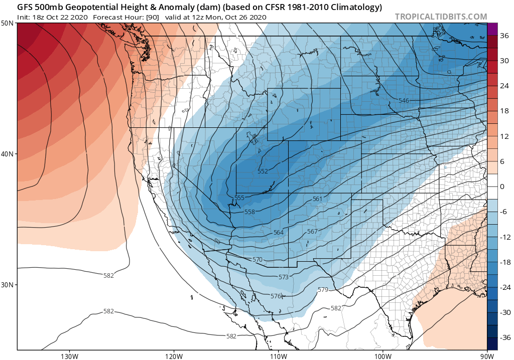
This event will be somewhat less anomalous across southern California, although a “cold Santa Ana” of at least moderate magnitude will still take place and fire risk will still be high.
Interestingly, there is still a bit of disagreement between the ECMWF and GFS regarding just how far west the low pressure system over the Great Basin positions itself. The ECMWF has it a bit farther west, which brings both stronger offshore winds but also the possibility of some scattered showers over the southern Sierra and parts of SoCal. While widespread precipitation is not expected, I would not be totally surprised to see some very light mountain snow showers or valley rain showers in far southern California before all is said and done. The GFS is completely dry, so this may not happen, but it’s worth a mention. In any case, any precipitation that may fall will not be enough to significantly alter the extreme fire weather risk–and none at all is expected across 2/3 of the state.
Extremely critical wildfire risk possible Sun/Mon SF Bay Area & Sierra west slopes
I want to highlight Sunday and Monday as a period of notably extreme wildfire risk in northern California. Red Flag Warnings will undoubtedly be issued, and PG&E will undoubtedly initiate widespread “Public Safety Power Shut-offs.” While my personal view is that previous PSPS events have been poorly managed–and our research does indeed show that they are probably happening too frequently relative to the actual meteorological risks–the Sun/Mon period is a good example of a particularly extreme event during which this kind of intervention probably does make sense. Winds in the Sierra Nevada and SF Bay Area may well be strong enough to knock over trees and powerlines in some areas. Avoiding powerline-caused fire ignitions during extreme wind events removes one of the key ignition sources for the kind of fast-moving and deadly middle-of-the night fires that have destroyed thousands of homes and killed dozens of people in recent years. But a key downside is that it also disrupts lines of communication and can hamper evacuations if a fire does ignite under extreme wind conditions by some other means (there are assuredly plenty of other means).
All of this is to say: the Sunday/Monday period will be a time to pay close attention to your nearby environment, and to do everything possible to avoid accidental fire ignitions. If a fire does start nearby under severe wind conditions, it might be wise to leave the area even before evacuations are officially ordered as they can sometimes come too late under such conditions. We may well get lucky and make it through this very strong wind event without any major new fires–that is my sincere hope. But one thing is clear: California’s fire season is far from over, and dangerous fires will continue to be very possible until widespread significant precipitation occurs. Currently, that is still not on the horizon.
Not just California: unprecedented late-season wildfires also rage in Colorado
While is most definitely still part of the traditional fire season in California, it is generally not so in the interior West. And yet, here on the other side of the Rockies, truly extreme levels of fire activity have persisted right up through the time of this writing. Last Saturday, I personally witnessed the now 10,000 acre Calwood Fire roar out of the Front Range foothills and down onto the plains–moving several miles over the course of just two hours and producing some truly extraordinary fire behavior including counter-rotating pryocumulus clouds, at least one large fire vortex, and a number of smaller satellite fire whirls. I captured some of this on video, below, and the rest via photo–which you can check out here (click thorough the whole thread). It was a scientifically fascinating but also objectively horrifying vantage point, to be sure.
And over the course of writing this blog post, I learned that the East Troublesome Fire (an understated fire name if there ever was one) has spotted *over the Continental Divide* in Rocky Mountain National Park after running through the town of Grand Lake last night–a truly extraordinary feat at any time of year, but especially so considering the calendar date and elevation. And yet…here we are. As in California, fire season 2020 has been an unprecedented one in Colorado–with both the single largest and 3 of 4 top 4 largest fires in modern history occurring since August. Rain and snow–throughout the West–simply cannot arrive soon enough.
Discover more from Weather West
Subscribe to get the latest posts sent to your email.