Warmer than average conditions continue into July
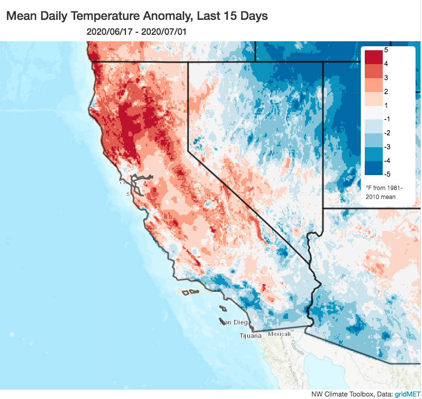
It has been an unusually warm spring and start to summer across most of California. But despite some pretty intense early-season heatwaves, the warmth over the past couple of weeks has been much more subtle–and even absent in coastal SoCal, where temperatures have been near or even slightly below average in recent days. This pattern is likely to reverse itself over the coming week–with interior SoCal experiencing a significant heatwave while NorCal merely edges upward into “somewhat warmer than average” territory.
Intense, prolonged heatwave across interior Southwest and Central U.S.; delayed monsoon onset
An unusually strong mid-level ridge will build directly over the interior Southwest in the coming days, bringing a very prolonged period (10+ days) of extreme heat to a wide swath of the U.S. extending from Arizona to Colorado to Texas. The possibility exists for numerous heat records to be set in this region between now and July 18. The most extreme heat will be confined to the central and eastern portion of this upcoming “heat dome”–meaning that most of California will not experience particularly extreme temperatures during this upcoming event. The major exception will be the southern and eastern interior deserts, which will indeed experience extreme heat this weekend (the Death Valley Visitor Center, for example, is expected to hit ~125F). Still, hot weather will occur throughout southern California (including coastal areas) by this coming weekend, and very warm conditions will also occur across NorCal (although they will be less anomalous).
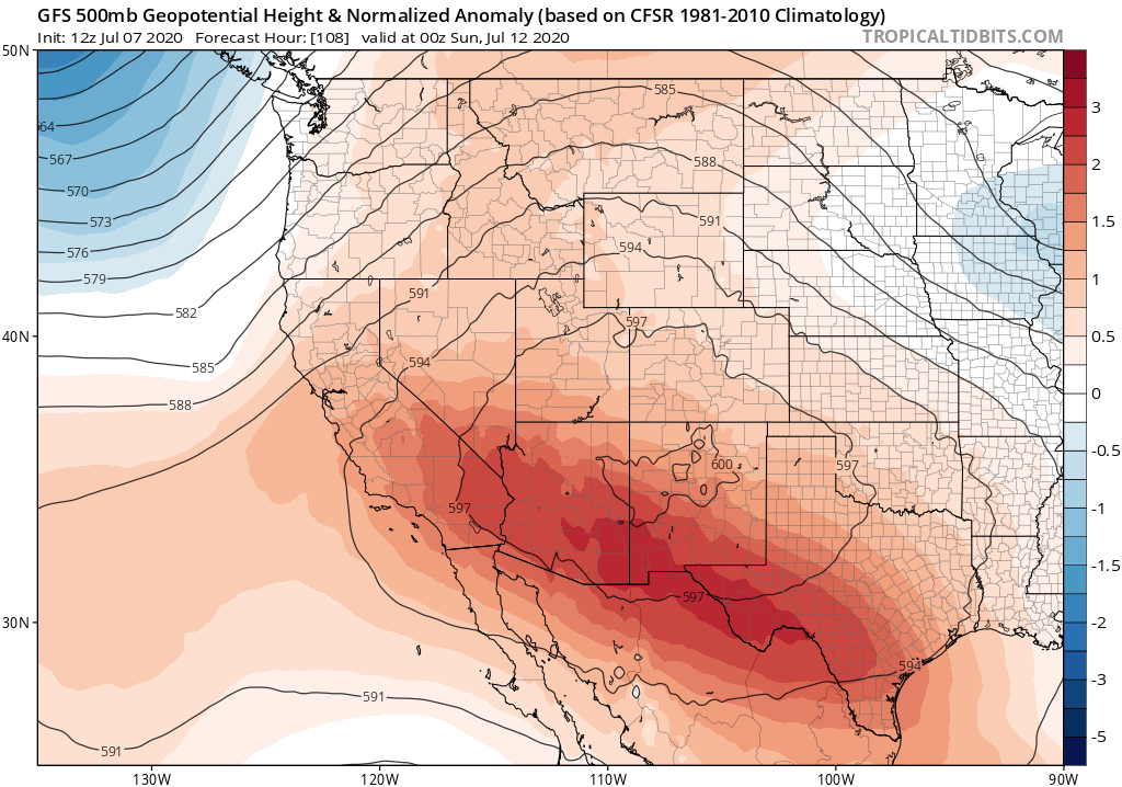
Unfortunately, the placement and strength of this ridge will preclude the incursion of meaningful amounts of monsoonal moisture into the Desert Southwest over the next 10+ days–meaning that the seasonal monsoon onset is likely to be delayed this year. This is not great news, as much of the interior West is currently experiencing an intensifying drought and a severe fire season (especially in Arizona, Utah, and New Mexico). The upcoming extreme heat in those regions, plus the lack of precipitation on the horizon, means that the peak of fire season there is likely to be more prolonged and intense than usual. This also means that prospects for monsoonal thunderstorms across California’s eastern deserts and the Sierra Nevada mountains will remain very low for the foreseeable future.

At the moment, there are mixed signs for the second half of July. Most model ensemble members suggest a tilt toward warmer than average conditions across most of California, but not extremely so. A few individual members suggest the potential for a very intense California heatwave toward the end of July, but those are in the minority at the moment. For now, we’ll just have to wait and see.
Early hints of a warm/dry autumn in California?
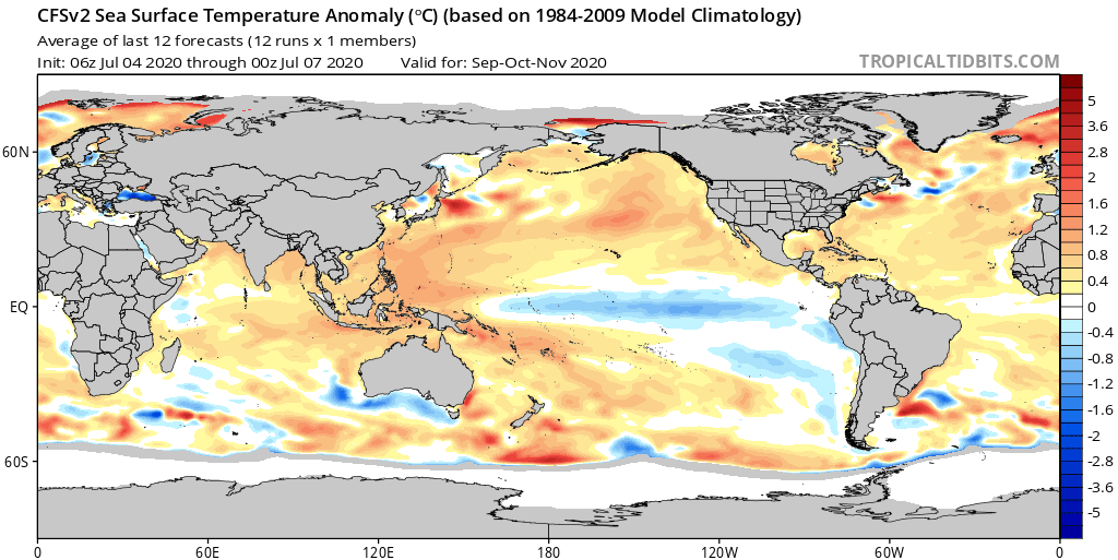
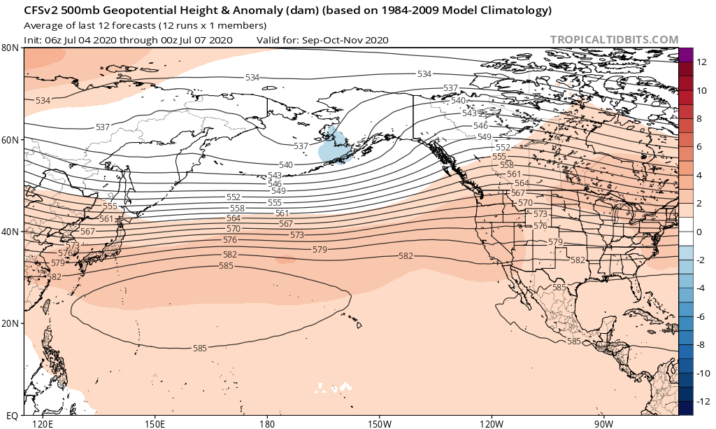
Since it’s currently the slow season from a California weather perspective, folks may be curious about the bigger picture and how conditions might evolve in the coming months. At the moment, most seasonal outlooks still call for the development of a modest La Niña event in the tropical Pacific, though one coinciding with widespread anomalous warmth in the extratropical North Pacific basin. Right now, it appears that these same models are rather strongly suggesting an elevated potential for enhanced northeastern Pacific ridging during the September-November period–which would elevate the potential for warmer and drier-than-average conditions across California during the peak of what is already expected to be a rather intense fire season. While seasonal precipitation predictions still have relatively low skill, the current strength multi-model ensemble signal is strong enough that’s it’s worth noting (especially given the state of the Pacific Ocean at the moment). It’ll certainly be interesting to watch how this evolves in the coming weeks.
Scheduling update: next Wednesday, I’ll have a research-focused blog post discussing our forthcoming paper on extreme atmospheric rivers in a warming climate. Stay tuned for that one!
Discover more from Weather West
Subscribe to get the latest posts sent to your email.