A dry (and warm, in most places) January in California
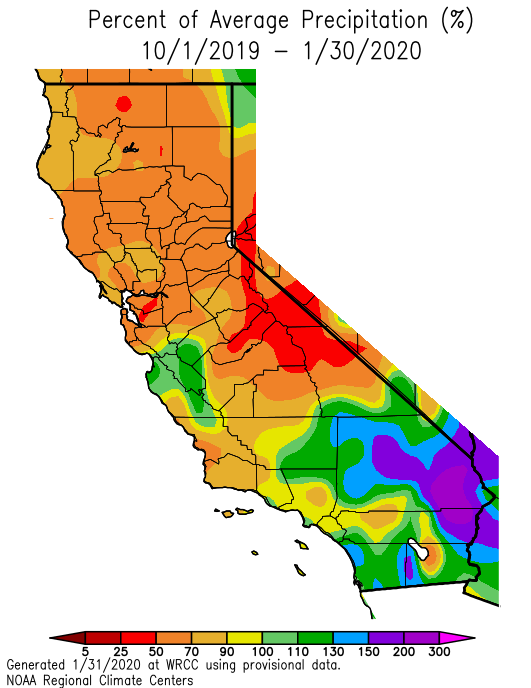
Unusually dry conditions have been the rule over northern California since the early autumn–where dryness has persisted and become more anomalous in recent weeks. In southern California, however, the recent dryness is in greater contrast to the abundant rainfall that fell during a relatively narrow window in late November and early December. Seasonal precipitation accumulation to date has now fallen well behind average (in some places, <50% of average) in northern portions of the state, and have finally started to fall behind in the south. January was also quite a warm month in (and just east of) the Sierra Nevada–Reno experienced its third warmest January on record. As a result of low precipitation and relatively warm temperatures, snowpack is now falling behind typical values rather quickly (currently around ~70% of average statewide). That said, state reservoir levels remain in good shape for the moment due to carryover from recent years–which will likely mitigate certain drought-related concerns from an urban and agricultural water use perspective. (In response to some recent discussion in the comments section: it is worth noting that drought impacts upon California’s ecosystems, and subsequently statewide wildfire risk, are not mitigated by water stored in the state’s reservoirs.)
Record warmth in some spots Saturday; then dramatic cold front on Sunday
Today is a warm one across most of California, but tomorrow will be even warmer. In fact, as a near-record strength mid-level high pressure system peaks overhead, I would expect some spots to set new daily record high temperatures on Saturday (especially away from the coast).
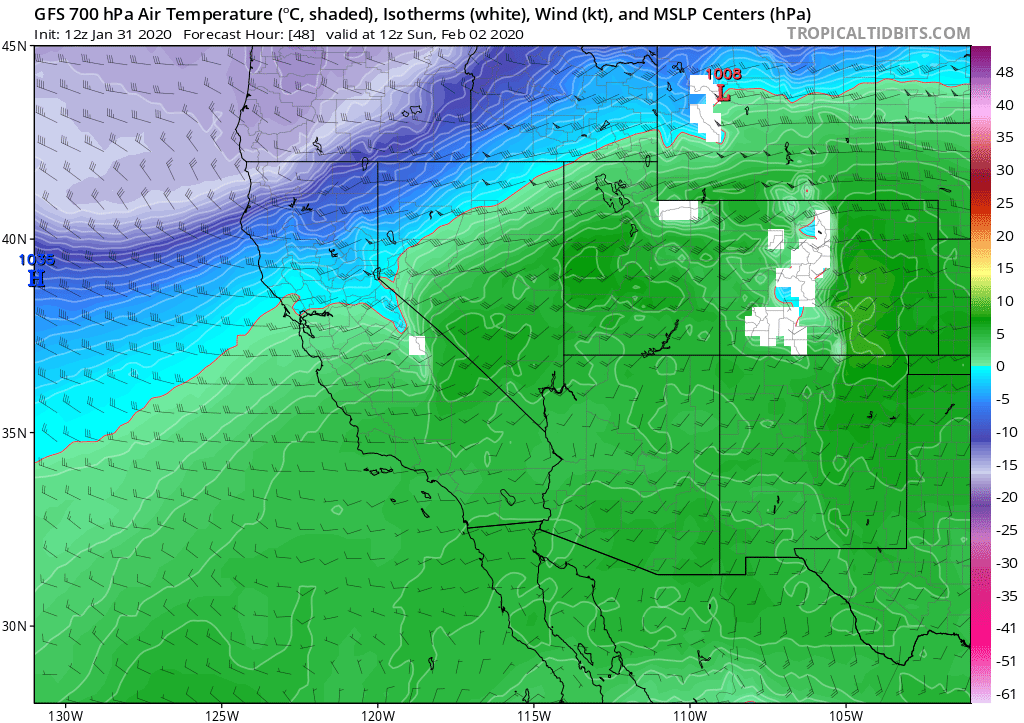
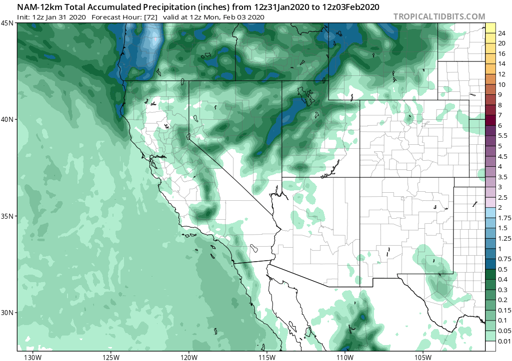
But these very warm winter temperatures will be rather short-lived. A remarkably sharp (by California standards, at least!) cold front will sweep across California on Sunday–bringing a dramatic shift to much colder temperatures and windy conditions nearly everywhere. This will be a very moisture-starved cold front, and in most of the state I would expect no precipitation at all (just some potentially very pretty clouds). There will likely be, however, a sudden burst of light to moderate snowfall in across most of the Sierra Nevada, which will come as a shock after Saturday’s record warmth. Additionally, given the extremely dry but rather unstable airmass over the state on Sunday following the cold front, there is a chance that isolated convective showers (with hail) could pop up in a few spots (most likely in the Central Valley and in the SoCal mountains). Generally speaking, though, this system is not expected to bring much moisture to the state.
Strong and gusty winds, however, will be widespread. While the immediate coast and Central Valley will see the strongest gusts (perhaps to 50mph or so), nearly all parts of the state could become quite gusty Sunday into Sunday night. Since this will be a northerly wind, rather than the more typical southerly wind ahead of winter cold fronts, these winds could cause a bit more disruption/minor damage than usual due to their a-typical direction.
Looking dry (but maybe cooler?) in February
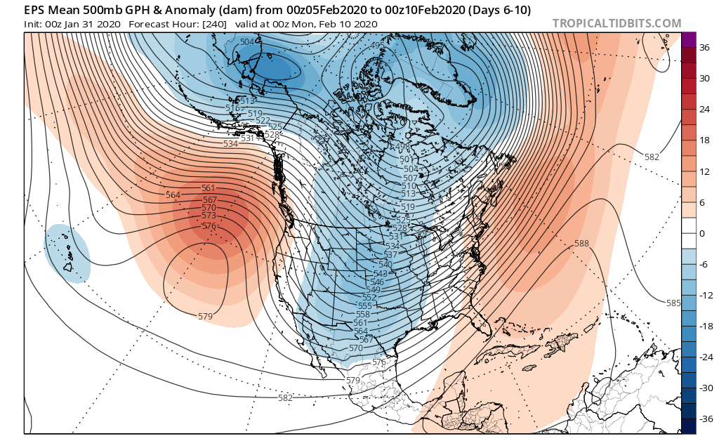
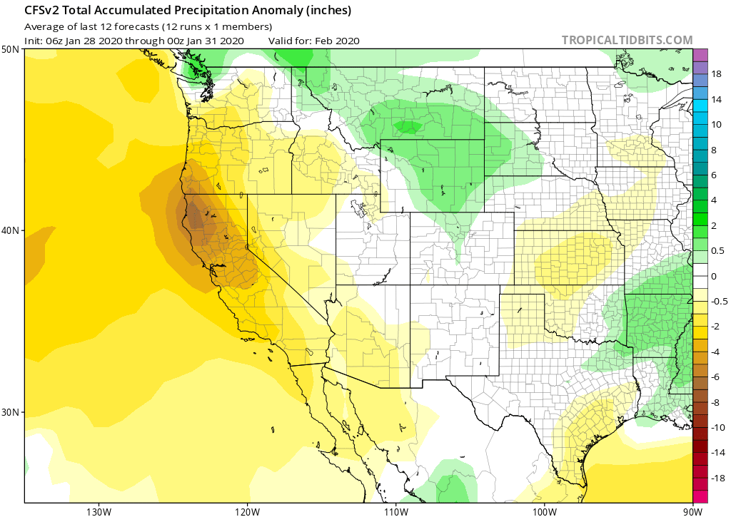
The long-range outlook does not bode well for significant precipitation. For quite a few days, the long range ensemble predictions have been suggesting a high likelihood that a strong and persistent blocking high pressure system would develop west of the West Coast by early February, perhaps persisting for 1-2+ weeks. Recent model solutions continue to support this scenario, which would bring a generally dry pattern to California for the foreseeable future. In fact, the monthly CFS prediction–which has demonstrated increasing skill in recent years–is also pointing to a very high likelihood that February (on average) will be a drier than average month in California.
There are a few caveats to this “dry ridge” scenario, though. First, unlike during recent major drought years in California, this persistent ridge will be located just to the *west* of California, rather than aligned right along the West Coast. While that’s still a favorable position to deflect the jet stream northward and bring dry conditions to California, it does potentially open up the door for dry but cold systems to occasionally drop almost due southward along the eastern flank of the ridge into California. Those types of systems are often similar to the upcoming one this weekend in that they produce little (if any) coastal precipitation and perhaps some dry, light snowfall in the mountains. But if the ridge pattern “retrogresses” just a few hundred miles to the west, that may open the door for these inside sliders to have a bit more over-water trajectory, and pick up more moisture. If that were to happen–as is indicated by a minority of model ensemble members–there would some potential for colder/unstable systems over coastal California that could bring at least some rainfall.
So my best guess for February, at the moment, is that it will be a drier than average (but not completely dry) month, possibly with a couple of opportunities for cold, dry, but unstable airmasses to produce light to moderate mountain snowfall and perhaps also some coastal showers (along with the kind of “interesting” weather that cold convective airmasses tend to provide). This is one of those situations where a small shift in the longitudinal axis of the East Pacific ridge will dictate whether conditions are extremely dry and rather warm, or merely drier than average (and also rather cold). But one thing that does appear likely, at the moment, is that seasonal precipitation deficits will continue to grow over the next 20-30 days. Stay tuned!
Discover more from Weather West
Subscribe to get the latest posts sent to your email.