The spring doldrums are here
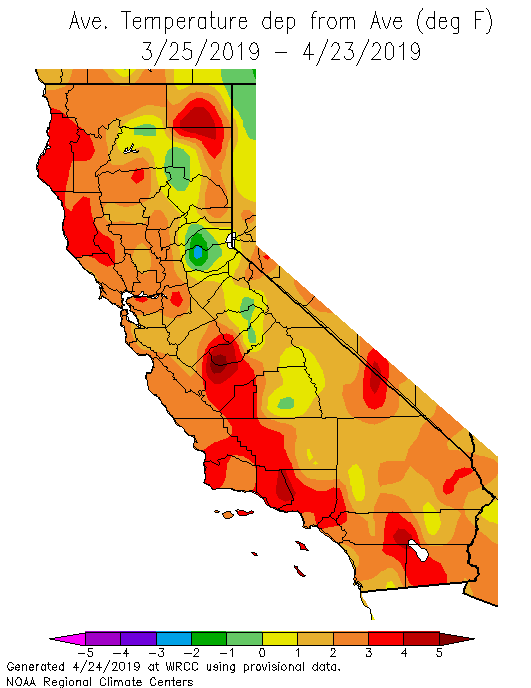
Following a banner snow season in the Sierra Nevada, snowmelt season is now well underway (though statewide snowpack remains fully 50% above the long-term average to date–the legacy of prodigious mid-winter accumulations). Temperatures across a majority of California have been well above average over the past month (especially near the coast), with recent days in particular featuring a string of record daily high temperatures (including some early 90+ degree readings across inland areas). This combination has led to fairly impressive snowmelt, and most snow-fed rivers in California are currently running fast and cold. Only minor flooding has been reported thus far, and currently there are no expectations of any serious snowmelt flooding on the horizon (although there is currently a Flood Watch out for relatively minor snowmelt flooding in the southern Sierra Nevada at the moment).
Otherwise, the spring doldrums have arrived in California (those of you who frequent the comments section may have noticed). This time of year brings relatively quiet weather most of the time, and the likelihood of particularly adverse conditions reaches an annual minimum: it’s too late in the season for major winter storms; too early for searing heatwaves or monsoonal thunderstorm outbreaks; wildfire season (especially following a relatively wet winter) does not really escalate until later in the summer before peaking in the early autumn. In other words: enjoy it while it lasts!
One of the few things to look out for during California spring is the occasional appearance of cut-off low pressure systems which have detached themselves from the directional flow of the jet stream. These often subtle and moisture-starved systems can nevertheless produce some interesting (but often very isolated) effects, as they tend to destabilize the atmosphere and can locally bring some dramatic weather in the form of thunderstorms, hail, and even the odd tornado (usually in the Central Valley). And right on schedule, or or more such systems may affect the state over the next 10 days.
Some thunderstorms possible across SoCal Sun/Mon; maybe further north later next week?
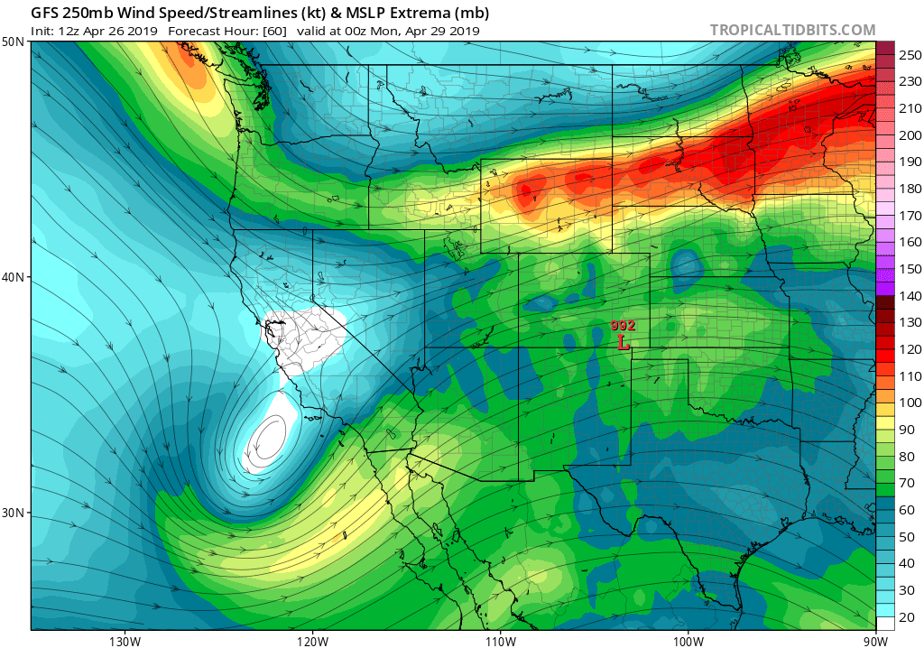
A cut-off low pressure system meandering across the northeastern Pacific will approach southern California from the west on Sunday, bringing increasing clouds and probably scattered showers and thunderstorms to most areas south of the Central Coast. While this system will contain very little moisture (typical of spring lows), it will contain relatively cold air aloft and will be associated with a weak jet streak whose right front quadrant (favorable for divergence aloft and upward vertical motion) will be located over the region late Sunday into Monday. As a result, I would expect Sunday and possibly Monday to be excellent cloud-watching days in Los Angeles and San Diego, and could feature some thunderstorms even over the coastal plain (the GFS and ECMWF actually agree on this). Rainfall will not be significant in most places; some spots will stay dry (though a few places may see heavy downpours).
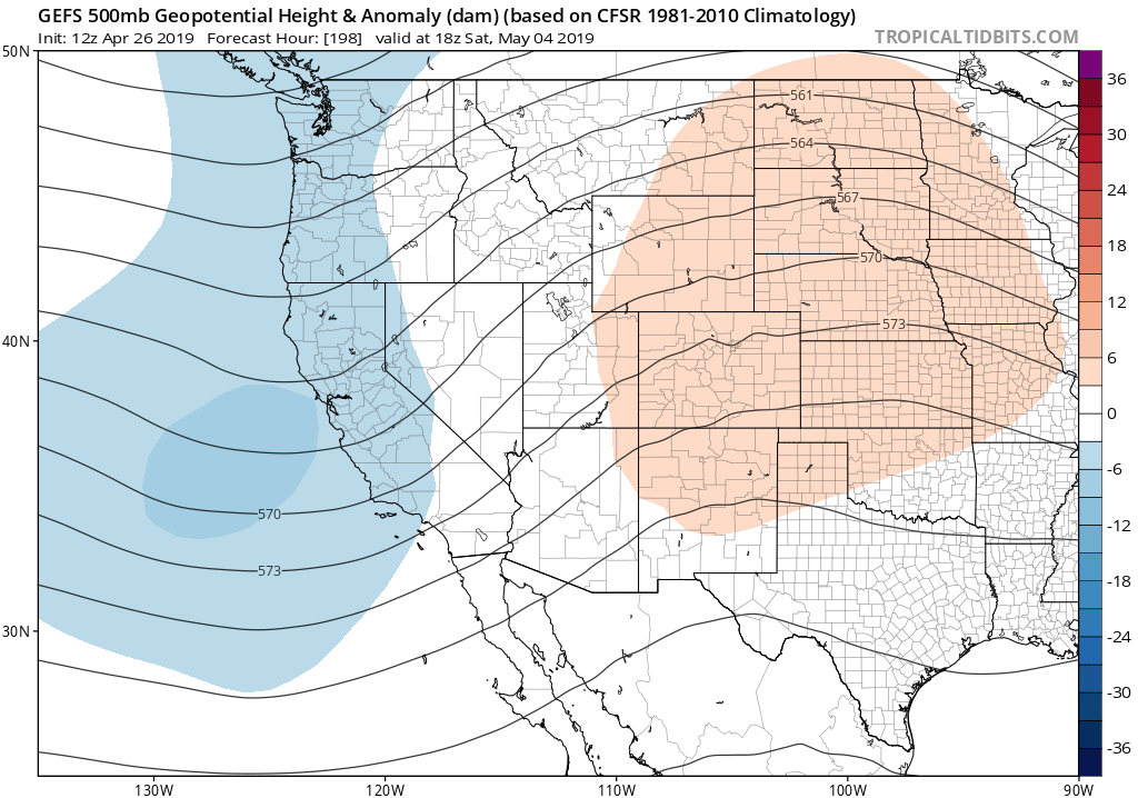
After that initial system clears out of the region by Tuesday, warmer and dry conditions will briefly return to the entire state. Thereafter, the GFS and ECMWF are once again in agreement that a relative unsettled May pattern may develop across California. Details are still fuzzy that far out, but there are a few indications that the Pacific jet may become a little more active than is typical for this time of year and will bring at least one weak low pressure system to Northern California in that time frame. Given the lateness of the season, any such system would potentially stand a good chance of producing scattered thunderstorms across a broader swath of the state than the early week low. To be clear: no widespread significant precipitation is expected, and temperatures may still remain above average. But increased prevalence of puffy, convective cumulus clouds will likely be noticeable to weather watchers across the state.
Weak El Niño and warm SSTs to persist
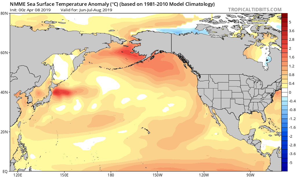
Weak El Niño conditions persist across the eastern tropical Pacific Ocean. This ENSO event has really not been that impressive thus far; long-distance teleconnections have generally not been very pronounced. Coupled atmosphere-ocean models suggest that the current event will likely persist in its present weak form through the summer and into the fall. Given the weak magnitude of the El Niño event, it’s doesn’t appear likely to exert any strong influence on California weather conditions in the coming months. The one exception may be related to near-coastal ocean temperatures, which are already elevated and are expected to become slightly more so over the next few months. (Note: this probably isn’t related only to El Niño–it’s also the product of other natural ocean variations and the long-term ocean warming trend associated with climate change).
Locally, warm SSTs don’t necessarily translate into an increased likelihood of “extreme” afternoon air temperatures or heatwaves. Instead, they tend to increase the likelihood of warmer, muggier overnight temperatures–especially in coastal Southern California (the North Coast, and SF Bay Area, are more strongly affected by localized but very pronounced cold water upwelling just offshore–which have recently mitigated the effect of broader Pacific Ocean warming). It’s worth noting that overnight temperatures in California have been warming around 3 times faster than daytime temperatures in recent decades–a pattern that is likely related to the effect of increasing near-shore water temperatures.
For those wondering: it’s still too early to say what ENSO might do next winter, and what the implications might be for seasonal precipitation, although there’s *not* currently any indication of a strong El Niño or La Niña event.
Discover more from Weather West
Subscribe to get the latest posts sent to your email.