Searing hot summer continues across CA interior (meanwhile, coastal denizens say “huh?”)
The overall pattern over California has been remarkably consistent thus far this warm season: exceptional, unrelenting, and record-breaking heat across interior and higher elevation areas (especially in NorCal), but relatively unremarkable temperatures along the immediate coast that have actually felt pretty chilly at times. It has been a summer of incredible contrasts between the beaches and…virtually everywhere else in California.
This divergence is reflected in the fire season so far–which has rapidly accelerated to historic proportions (yes, even given the context of the last few years) across the northern 1/3 of the state. The Dixie Fire is now the largest single-origin wildfire in modern California history, having burned ~500,000 acres as of this writing. (Yes, I am aware that the August Complex last summer was larger, but that was composed of multiple distinct fires that merged; I am also aware that the Fly Fire near the Dixie may perhaps have been a separate start rather than a spot fire, but it was quite small (<2,500 acres) when it was subsumed by the massive oncoming fire front.) In addition, numerous new fires were ignited by lightning over the past 10 days across Shasta, Modoc, and multiple counties in NW California. Some of these have already burned tens of thousands of acres, are burning in remote areas, and are therefore likely to burn for weeks (probably until the onset of widespread precipitation this autumn/winter).
Yet another record-breaking heatwave across PacNW will bleed into interior NorCal
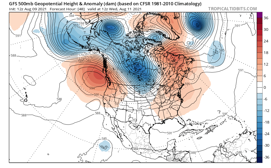
Incredibly, it looks like a (somewhat lesser) version of the record-shattering heatwave across the Pacific Northwest and British Columbia will repeat itself this week. The synoptic pattern, and its surface weather impacts, look almost eerily similar–though the magnitude appears to be noticeably less. But that’s really only because the June 2021 event shattered every record there was to break up in those parts–were it not for the June event, the upcoming event this week would probably have threatened all-time, any-month records in places like Portland and interior B.C. So this is still likely to be a very major heat event for most of Oregon, Washington, and B.C. (with many daily and perhaps monthly records broken), and will also bleed over into much of interior NorCal (i.e., the same parts of CA that have been so hard hit with heat and fires so far this season). Excessive heat watches/warnings are now in effect for much of far N and NW CA at this time, which includes, unfortunately, virtually all of the major fire zones in NorCal (and southern Oregon). I hate to say that it looks like more of the same from earlier this summer, but…it looks like more of the same. It will be relatively hot across the rest of the CA interior, with a long stretch of triple digit temps in the Central Valley and SE deserts once again (although I don’t think too many records will be broken this time). The coast will remain pretty mild, yet again, although probably not as chilly as in June as ocean temperatures have warmed since then and the marine layer is not quite as robust.
Renewed monsoonal moisture surge could bring some more Sierra thunderstorms, with slight lightning risk elsewhere?
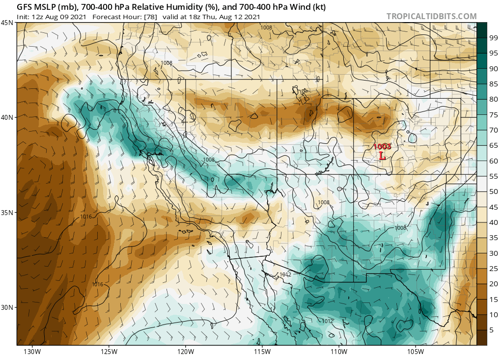
I’m also foreseeing a bit of a repeat of the kind of mixed monsoonal pattern discussed in the last blog post. This upcoming one will not feature as deep of a moisture surge, so storms in general will probably be less widespread and not as wet (although some big downpours are still possible, locally, in the SE CA deserts). Fortunately, the last two potential dry lightning events were fairly limited in CA (although they were not total busts–there have still been quite a few lightning fire ignitions over the past 2-3 weeks in NorCal). This potential upcoming event will hopefully be unremarkable, too, but at the moment it’s too early to tell. There are some ingredients that will keep fire weather forecasters on their toes this week, with a couple of rounds of elevated moisture and instability over central and northern CA beginning around Wednesday and perhaps continuing on and off through the weekend. Neither of these look especially dramatic at this time, but as I keep pointing out: it’s not always easy to tell which *potential* summer lightning events in California will actually end up bringing lots of lightning. The *potential* is certainly present again this week, although it is slight. Lightning will be more likely across the Sierra Nevada, SE deserts, and far northern mountains–where it would more likely be accompanied by some precipitation. But it will still be worth keeping a close watch on the the potential for some dry strikes elsewhere in CA this week, all the way west to the coast. At a minimum, hot and unstable conditions across existing fire zones may lead to dangerous, plume-dominated fire behavior.
End of August looks cooler, but may come with increased winds in fire-besieged NorCal
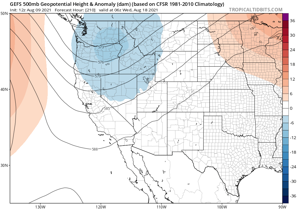
There is some mixed news, at the moment, for the end of August. On the positive side, there are some signs of a very weak early season (dry) trough over the Pacific Northwest. That will probably act to cool things down over CA and the West Coast in about 10-12 days, and there may even be some below average temperatures for a few days! But it will also significantly increase the potential for some stronger westerly and southwesterly winds in NorCal, which could further accelerate fire spread on existing fires. The sequence of “yet more intense heat, then possible lightning, then possible strong westerly winds” is really not a great progression given the scope and extremity of the fires already burning in densely forested and heavily drought stricken parts of interior NorCal–so consider this an early heads-up on different kinds of adverse conditions coming up over the next 1-2 weeks.
Discover more from Weather West
Subscribe to get the latest posts sent to your email.