Quiet spring conditions persist in California, but late summer/autumn could look quite different
Warmer-than-average conditions from mid-April to mid-May hasten snowpack melting
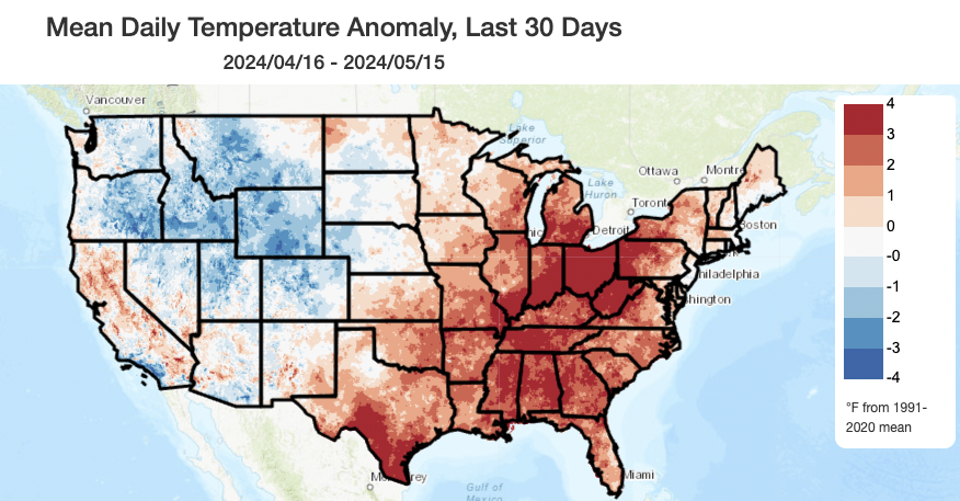
The past month has been a fairly mild one across much of the Western U.S., with many areas near or below their most recent 30-year average (with the reminder that this recent baseline is ever-shifting in a warming climate: such temperatures would have been warmer than average for most of the cooler 20th century). In California, however, the mid-April to mid-May period was actually somewhat warmer than the recent baseline period in most regions–especially in northern CA and the SE deserts. (Coastal SoCal, however, was actually near to below the recent average during this period.) This relatively warmer period peaked over the past week, when many areas across the CA interior (including the central valley) saw hot early summer-like temperatures in the 90-100F degree range.
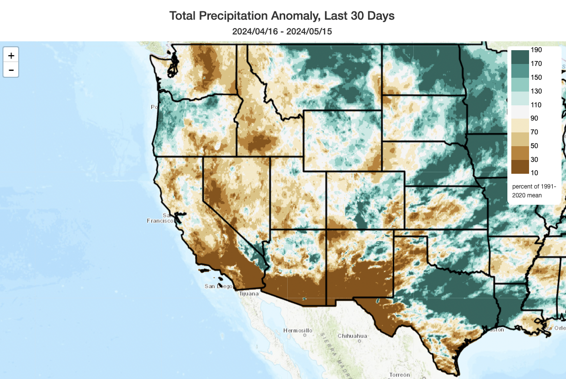
The last 30 days have also been pretty dry across most of the Southwest and California, with some localized exceptions. Southern and central CA were nearly dry during this period–marking a pretty sudden end to several months of exceptionally wet conditions in coastal SoCal. Together, the warmer than average (primarily) and drier than average (secondarily) conditions contributed to fairly rapid melt of Sierra snowpack during this period: snow water equivalent relative to the calendar date average on a statewide basis fell from over 100% of average in early April to 78% of average (and 56% of average in the Southern Sierra) as of today. Neither the relatively fast snowmelt nor the sudden drop in SWE are particularly concerning in context–this is now the second year with near-average or better snowpack (last year’s was extraordinary, and this year’s was “fine”) and above average seasonal precipitation statewide. But it does highlight how the Sierra did not benefit as much as coastal areas did this past winter–very much unlike 2022-2023, when it was very wet virtually everywhere and also much colder than average (this winter was not nearly as cold, either).
A cooler but mostly dry late-spring pattern for the rest of May, but warmer again by early June
Last week’s unusually warm early season heat will give way to cooler temperatures once again over the next 5-10 days as a sequence of weak and mostly inside-slidery low pressure systems move across the interior West amid a troughier West Coast pattern through the end of May. Precipitation is unlikely in CA outside of some isolated showers along the North Coast and Sierra Nevada (where isolated thunderstorms could also occur) at times during this period, along with the potential for some (potentially measurable) drizzle along the immediate coast from a seasonably deep marine layer there. Breezy conditions could occur at times, as well. Generally, though, this will be a period of quite benign weather across California.
There are signs in all model ensembles that a broader and stronger ridge will build across the interior West by early June–perhaps bringing warmer and even above average temperatures across much of the Southwest and likely the CA interior again during this period. However, there are no signs of extreme heat at this time in CA, and it’s quite plausible that the marine layer (May Grey transitioning to June Gloom) will hold strong during this period. So it could well be a classic June set-up where coastal areas remain cool, foggy, and locally damp, but inland areas get pretty toasty.
An (updated) look ahead: strong signs of hot (and dry?) Aug-Oct in CA & SW

As I’ve mentioned previously, I don’t believe our relatively mild spring (and, probably, early summer) will persist past July or August. In fact, the latest multi-model ensemble update cycle brings even higher confidence of a very hot late summer and autumn to come across much of North America–California included. In particular, global predictive models seem to be keying in on the development of a very strong mid-level ridge across the Southwest by mid-summer, along with pretty strong odds of a weaker-than-average monsoon across the Desert SW and possibly a late/weak start to the rainy season in CA. There’s much more confidence in the prediction regarding “ridge-y and hot” conditions from Aug-Oct vs the precipitation outlook–but, combined, they portend a late summer and autumn that could bring very active wildfire conditions to much of the U.S. West after fairly quiet conditions the past couple of years amid wetter conditions and a plateau in regional temperatures. I’ll continue to follow these seasonal developments as they unfold.

In case you missed it: my views on the problem with “climate optimism versus climate pessimism” framing
Occasionally my live and interactive YouTube “Office Hours” run long–and when they do, it’s usually because the discussion and conversation has been really engaging! Last week’s session was one such example, and I strongly encourage folks to check the recorded version of this one out if you’re interested in my own thoughts on the recent discourse surrounding “climate change optimism versus pessimism” (TL;DR: I find it to be a very frustrating framing).