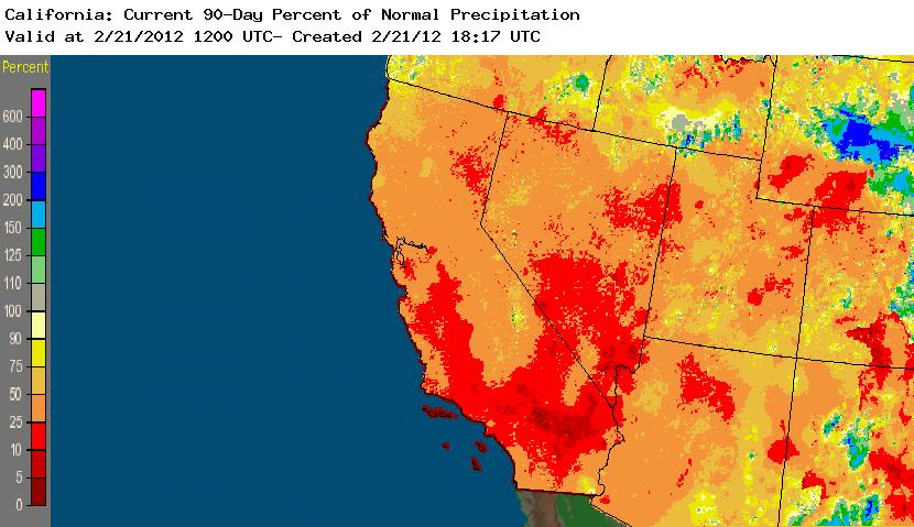
As has been case for the entirety of the traditional “wet season” thus far, California continues to experience very dry conditions. Though the length of absolutely dry periods has decreased in recent weeks, the dry spells have been punctuated only by brief periods of light or very light precipitation (with a couple of highly localized exceptions). Cumulative precipitation totals for the water year, winter season, past month, and–despite some recent precipitation–even for the past week are all well below normal across nearly the entire state (and, for that matter, across most of the Southwestern U.S.). In fact, the most recent update from NWS/CPC indicates that most of California (and Nevada, and Utah, and Arizona) has received less than half of typical precipitation so far this winter, and over a third of the state has received less than 25% of average during the three months that usually make up the peak of the rainy season in our region.
The wide geographic scope of the very dry conditions across the Western United States is indicative of the type of prevailing weather pattern that has led to the present situation: rather than a long train of “near-misses,” whereby numerous storm systems miss California either to the north (bringing copious rains to the Pacific Northwest) or to the east (in the form of “inside sliders,” bringing widespread rain and snow to the interior West), there has been a remarkable dearth of storm activity across the entire Western third of the country. The most immediate cause of this impressive dryness has been the persistence of an anomalous ridge over the Northeastern Pacific for essentially the entire winter.
Teleconnections between California wintertime precipitation and tropical convection in the Western Pacific are well-known, and on intra-seasonal timescales the Madden-Julian Oscillation tends to be a good indicator of the potential linkage at a given point in time. This winter, the MJO has been very quiet–regions of suppressed/enhanced tropical convective activity have been small and longitudinally stationary. Such behavior is not particularly unusual during a La Nina event, but there are usually some other aspects to the hemispheric pattern during Eastern Pacific cold events that usually bring at least modest (often cold) precipitation to much of the American West. This year, we haven’t really had any amplified meridional flow over the U.S., which has prevented the kind of sub-polar incursions that might otherwise have boosted our presently meager precipitation totals.
The all-important question, of course, is whether we might finally receive some late-season precipitation that could at least mitigate the effects of the very dry season thus far. While I see little hope of significant precipitation anywhere in California through the end of February, there are some recent changes in large-scale conditions worth considering. In the past 1-2 weeks, a rather strong MJO signal has emerged in the Western Pacific and is slowly propagating eastward. The first question is whether this signal can hold itself together and continue to propagate into a position favorable for forcing an amplified Pacific jet stream. The second question, of course, is whether we would even see any rainfall out of a strengthened zonal jet given the magnitude of the entrenched Pacific ridge. Only time will tell on this front, though it’s worth paying attention to the large-scale pattern in the 2-3 week range.
Secondly, La Nina appears to rapidly be on its way out of the picture. SST anomalies in the traditional Nino 3/Nino 4 regions have actually gone positive in the last few weeks, and there’s even a subsurface pool of warm water around ~300 m. In addition, there are presently strong westerly wind anomalies in the Eastern Pacific, which will only contribute to additional surface warming. While this is probably a positive development with respect to long-term rain prospects, it’s unclear if the transition to ENSO-neutral conditions will occur soon enough to have a significant impact on water year 2011-2012. It’s still too early to be talking seriously about El Nino prospects, though I will say that some of the dynamical models are indicating positive SST anomalies by mid-summer.
As always…stay tuned.
© 2011 WEATHER WEST
Discover more from Weather West
Subscribe to get the latest posts sent to your email.
