Hot, hot summer: all-time record heatwave in SoCal in early July, and more heat to come

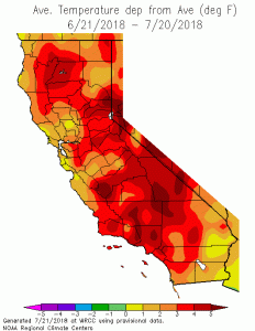
One of the most impressive heatwaves in recorded history brought truly blistering heat to Southern California earlier this month. Nearly every kind of of temperature record was broken in at least a few locations, from all-time daily maximum to all-time overnight minimums, and a countless daily/monthly records. This heatwave was especially notable at least three distinct ways. First, extreme temperatures made it very close to the coast (for example, UCLA hit 111 degrees–an all-time record in any month). Second, extreme warmth persisted into the nighttime hours: temperatures near 100 degrees occurred after midnight in some places during the peak of the event, with lows failing to drop below 80 degrees at any point for several days in some spots (and setting all-time record overnight temperature records in the process). Finally, the “downsloping” winds that brought extraordinary compressional warming to the coastal plain in SoCal occurred out of season: those conditions are much more common in the autumn, when the overall airmass is somewhat cooler. The 120 degree reading in Chino, CA (about 20 miles east of Los Angeles) during this event was not only an all-time record at that site, but most likely the highest verified temperature ever recorded within 100 miles of the Southern California coast.
Interestingly, Northern California has generally not experienced the same kind of searing heat that has occurred in SoCal. While temperatures have generally been running well above average even up north (with the exception of portions of the SF Bay Area, where a persistent marine layer has acted as a natural air conditioner much of the time), there have not been a great number of extremely hot days so far this season. This type of subtle warmth is perhaps best reflected just across the state line in Reno, Nevada–which is presently on track to experience its warmest July on record despite not having experienced any daily records for the entire month to date! In fact, it is possible that California may experience its warmest July on record on a statewide basis, bolstered by both the extreme heat in the south and the more subtle but still anomalous warmth up north.
New, prolonged heatwave beginning Monday (focused mainly in SoCal and inland CA)

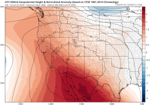
Yet more heat is on the way, and it will affect most of the same areas that have been hardest hit so far this summer. While this event will almost certainly not feature temperatures as extreme as the early July event, numerous daily records could still fall in SoCal between Monday and Thursday of the upcoming week. The immediate coastline will be spared to a greater degree than during the previous heatwave, but it will still be quite warm there as ocean temperatures have risen pretty dramatically in recent weeks and are xproviding a relatively high “floor” on coastal air temperatures at the moment. Very warm overnight temperatures could once again occur during the upcoming heatwave, and there may even be some weak downsloping “sundowner” winds across portions of SoCal which bring high fire danger and compressional heating. Perhaps the most notable aspect of this event will be its longevity–the heatwave will not “break” in any distinct way. Instead, by Friday or Saturday next, the heat will slowly fade away as the ridge weakens overhead. Interior NorCal will experience widespread triple digit temperatures during this event, but that’s not especially unusual for late July and this event won’t be especially exceptional in the north.
Long range: still looks hot; monsoon may re-surge

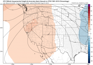
There is still pretty good agreement between the GFS and ECMWF ensembles that the typical Four Corners high will remain a bit stronger on its western flank than usual for the foreseeable future, increasing the likelihood of hotter-than-usual temperatures across southern and interior portions of California. A temporary weakness in the ridge may allow a renewed surge of monsoonal moisture to enter the state from the east about a week from now, which would bring muggy conditions and perhaps more thunderstorms to some areas, but at this point it’s too early to discuss the details. Also, warming near-shore ocean temperatures may act to keep things warmer than average for at least several weeks to come-especially in SoCal, where SSTs are as high as 75 degrees at the moment.
Finally, if you’re interested in hearing a bit more about the recent Southern California heatwave, the extraordinary heat being observed elsewhere in the Northern Hemisphere this summer, and how these events fit into the broader context of climate change, feel free to listen to this interview recorded last week featuring Noah Diffenbaugh (Stanford), Marty Hoerling (NOAA), and me.
Discover more from Weather West
Subscribe to get the latest posts sent to your email.