Summer in January; Sierra Nevada snowpack nears record low
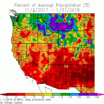
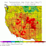
Despite the calendar, it sure hasn’t felt much like the middle of winter across California in recent days. While well above average temperatures and below average precipitation have been widespread throughout the state, recent warmth and dryness have been especially concentrated across Southern California. Immediately following the warmest autumn (and before that, warmest summer) on record, a legitimate mid-winter heatwave baked the southern third of the state this week, setting numerous high temperature records. In fact, anomalous offshore flow brought daytime temperatures near 90 degrees and overnight lows above 70 degrees near the Pacific coastline–temperatures that would be well above average in these areas in June, let alone January.
While temperatures in SoCal have now moderated somewhat, they’re still quite mild for this time of year (running a “cool” 10-15+ degrees above average).
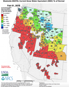
Additionally, this highly anomalous warmth has now spread northward across the rest of the state–bringing spring-like temperatures to the Sierra Nevada and inducing unusual mid-winter snowmelt. The statewide snowpack has already been tracking near record-low levels for most of the winter (partly due to modestly below average precipitation but mostly due to far above average temperatures), but the ongoing warm and dry spell will likely melt what little snow currently exists below about 8000 feet in elevation. The lack of snow in California so far this winter is actually part of a much broader “snow drought” that currently extends across most of the mountainous interior of the American West, from the Cascades in Oregon to the Front Range of the Rockies in Colorado. Much as in the Sierra Nevada, these largely snow-less conditions are the product of both below average precipitation and above average temperatures across a wide swath of the Southwest so far this season.
“Severe drought” has returned to parts of Southern California
Today’s update of the U.S. Drought Monitor suggests that “severe drought” conditions have returned to parts of Southern California–most notably, Santa Barbara and Ventura Counties, where huge tracts of land have recently been burned by the nearly 300,000 acre Thomas Fire (in December) and/or the localized but devastating debris flows and flash floods (in early January). That might not come as a surprise to local residents–many of whom will point out that California’s multi-year, statewide 2012-2016 drought never really ended locally (where Lake Casitas, the only source of water for several communities, is running at about 35% of capacity). While the Northern California reservoirs are generally in much better shape due to carry-over from last year’s deluge (and California’s big cities, which are all tied into the state water system, are therefore unlikely to experience water restrictions this year), California’s wildlands and ecosystems will most likely experience more immediate adverse impacts from yet another warm, dry winter. The recent drought was a major factor in the bark beetle-linked mortality of well over 100 million Sierra Nevada trees in recent years. Despite last year’s wet and cooler reprieve, these drought and beetle-stressed forests have yet to recover from the intense multi-year drought that preceded it–so there is serious concern that forest mortality could accelerate once again during the upcoming dry season.
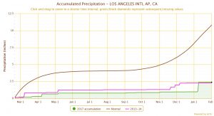
Just how dry has it been in Southern California? As a current resident of Los Angeles, I found the following statistic especially striking: if the city reaches February 19th, 2018 without a significant rain event (as currently appears plausible), there will have been only a single day with more than a third (0.33) of an inch of precipitation in the preceding 365 days–a full calendar year.
A big West Coast ridge has returned…and it looks pretty resilient
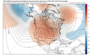
At risk of sounding like a broken record: a strong, persistent, broad, and anomalous ridge of atmospheric high pressure has yet again set up along the West Coast. All indications are that it will probably stick around for the foreseeable future (certainly for the next 10 days, and plausibly for the next 2-3 weeks). This may sound a bit odd to those accustomed to the typical weather prediction mantra that anything out beyond about 7-10 days is essentially unpredictable. But recent evidence suggests that under certain circumstances, large-scale atmospheric predictability can be much higher over longer periods. The present instance of prolonged, stable ridging near the West Coast appears to be one of these situations, given the remarkable multi-model ensemble agreement that the large-scale flow pattern is unlikely to change much through at least mid-February (and perhaps even longer than that).
One atmospheric dynamics-related reason for this high confidence: the Madden-Julian Oscillation (MJO) yesterday reached its highest amplitude in recorded history, and appears to be be “stuck” in a phase that favors strong West Coast ridging and warm/dry California conditions. MJO-California weather linkages are a complicated topic that’s a bit beyond the scope of this brief blog post, but there are some good resources out there on the web for those who are interested in learning more.
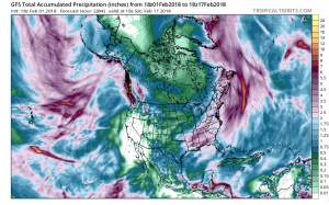
This doesn’t mean that it will be completely dry across the entire state, but it does suggest a very high probability of far above average temperatures and well below average precipitation during what is typically the wettest part of the year in many parts of California. This appears to be an unfortunate case where the seasonal forecast models–which predicted a warm and drier than average winter in California, especially across the south–did a pretty good job. As many folks have pointed out, California’s seasonal precipitation is often dictated by the occurrence of just a handful of strong storms each year–so it’s still possible that a robust storm sequence in late February (or another “Miracle March“) could bring a remarkable turnaround in short order. But while that possibility remains on the table, the odds are long.
Some brighter news: a Weather West milestone!
Recently, the Weather West blog hit a bit of a milestone: 10 million visitors since 2006! Even more impressive, I think, are the 250,000 (and mostly on-topic!) comments that have accumulated (occasionally over 5,000 per blog post!). That’s a real testament to the engaged community that has flourished here over the years. I want to sincerely thank everyone who has helped make this site what it is today!
Discover more from Weather West
Subscribe to get the latest posts sent to your email.