A dynamic and changeable spring 2026 weather pattern in California amid ongoing marine heatwave
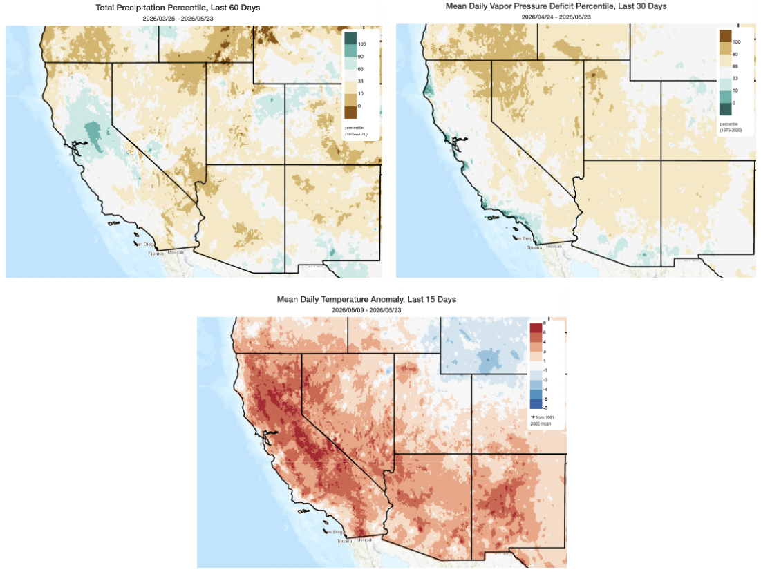
As we approach the end of May, it’s worth looking back at the past couple of months of highly changeable weather conditions across California and the West. Spring is always, to some degree, a tumultuous weather period, as it heralds the messy transition period between winter and summer when both winter-like and summer-like conditions are possible (and sometimes in quick succession). But some years, that transition is seemingly singular in California with the flip of a switch: cold, wet conditions give way to warm and dry ones. In other years, the switch keeps flipping on and off, with repeated swings between wet and dry and warm and cool. 2026 has certainly been one of those “swingier” springs, and that reality is perhaps accentuated by the record-shattering heat that occurred in late winter, and especially in March. Some places have only just begun to see temperatures approach or eclipse their genuinely shocking March values–which is a testament more to the extremity of the March heatwave than relative coolness today.
In fact, the past two weeks have been significant warmer than even our warmer-climate recent baseline across most of California. There have certainly been colder and wetter interludes over the past 2 months, including late-season precipitation throughout NorCal and even some late season Sierra snow. But overall, despite being much cooler in relative terms than March, April and May have still been warmer than even the recent average across most of California (with only local exceptions).
Over the past month or so, precipitation has continued to be above average right along the very same “Interstate 80 Axis” from about San Francisco northeastward to the Tahoe Basin, but has actually been below average nearly everywhere else in California and the Southwest as low pressure systems repeatedly favored this recurring narrow corridor. Also notable is the recent uptick in northwesterly winds along and just offshore of the northern and central California coast–thanks to enhanced surface high pressure well offshore–which has reinvigorated recently anemic near-coastal upwelling and thus temporarily reverse the near-shore portion of the long-term marine heatwave along the California coastline north of Monterey. South of Monterey and even ~100 miles west of San Francisco and the North Coast, the marine heatwave continues in earnest and is actually still breaking records. But along this narrow coastal strip, this burst in enhanced coastal winds has brought cold water to the surface that will likely remain for at least another week or so.
These same northerly or northwesterly winds that interrupted the NorCal marine heatwave also brought much lower inland humidities, as well as a considerable uptick in grass and brush fire activity, in recent days. This was most pronounced in SoCal, where quite a few notable but mostly non-damaging wildfires broke out amid hot, dry, and windy conditions in a setting of increased herbaceous fuel loading (read: extra grass and brush growth thanks to recent wet years). This, combined with the marine heatwave, has resulted in an interesting “humidity/vapor pressure deficit dipole” wherein the immediate coastline has experienced exceptionally moist air in recent weeks (among the moistest on record for May, in fact!) but inland areas have actually seen unusually dry air thanks to northerly or even offshore winds plus a subsident airmass.
All in all, this has already been a rather different spring than recent ones, as coastal regions have not been nearly as chilly. While fog and low stratus have still occurred along the coast at times, the marine inversion has been less persistent so far and temperatures both within and above the fog layer have been notably warmer than recent “severe May Gray” regimes. And the occasional (and ongoing) precipitation, especially in NorCal, has kept the growing season going a bit longer than usual in many locations as well.
Yet another cut-off low pressure system this week will bring cooler temps, showers in mountains (& locally elsewhere), and coastal drizzle from enhanced marine layer
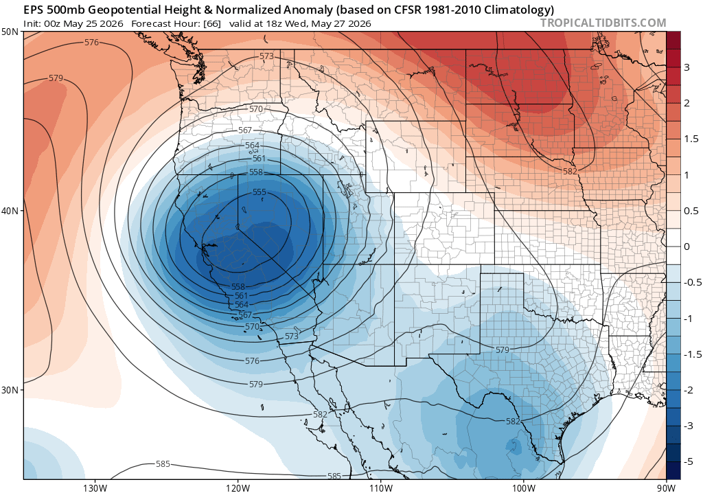
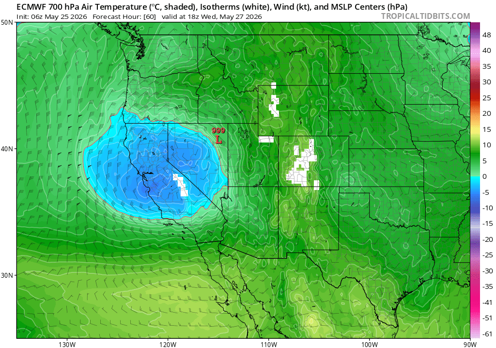
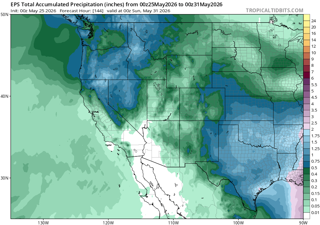
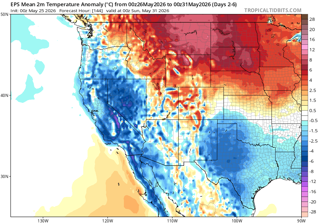
In keeping with the highly dynamic pattern that has dominated thus far this spring, another significant cut-off low pressure system will develop and drop southward over California and Nevada early this week. It’ll be accompanied by pretty cold air aloft for the time of year, which will likely combine with strong late May sun to generate steep lapse rates with decent instability across much of NorCal. This system will be moisture-starved, so most showers (plus scattered thunderstorms) will occur over the mountains, but a few isolated showers or even thunderstorms could probably pop up elsewhere (including some “surprise” locations) by virtue of this unstable but relatively dry airmass. A few high Sierra snow showers are also possible. Also, because this system will generate some strong and gusty winds, it may locally increase the risk of wind-driven grass fires once again in places that don’t see any precipitation.
In addition to mountain showers and thunderstorms plus a few isolated convective pop-ups elsewhere at lower elevations, there will probably also be some measurable coastal drizzle from a temporarily enhanced marine layer along the coast from about San Francisco Bay Area southward. In some parts of SoCal, this could yield a solid tenth of an inch or so!
As you might expect, the first half of this week will be much colder than recently until this low pressure system moves eastward. Temperatures along the immediate coast of SoCal will remain elevated due to the warm near-shore ocean, but elsewhere it’ll be noticeably chillier than it has been recently.
Considerable warming once again likely by early-mid June; NorCal marine heatwave likely to rebound during this period
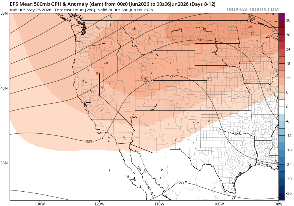
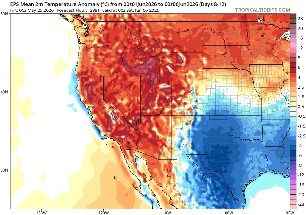
Looking ahead to early-mid June, however, a significant pattern shift is possible. At present, it appears likely from ensembles that a blocking ridge will develop at a somewhat higher latitude across the West, somewhere between the Pacific Northwest and the Northern Rockies (as it turns out, this is a pattern favored during transitional ENSO summers when the subtropical jet remains unusually active across SoCal and Mexico, as at present). This will likely mean a return to broadly warmer than average conditions across the West, including California, during this period. (In other words, warmer than average but probably no extreme heat in California during this period, but more extreme heat in relative terms is certainly possible elsewhere to the north.) This is generally a pattern that favors highly anomalous heat across the PacNW and western Canada, but only moderately anomalous heat over California (and there is still a slight chance that weak low pressure systems sneak through underneath the blocking ridge). Still, this likely portends a return to much warmer weather in California and perhaps also weakening of the recently reinvigorated upwelling along the NorCal coast, so near-shore ocean temperatures could potentially rise again during this period. Occasional breezy conditions could once again bring periods of elevated grass and brush fire activity, as well, through for the moment the higher elevation forests in California remain too damp for major fire activity.
Outlook for summer and beyond increasingly dominated by now-likely trend toward strong (or very strong) El Niño; more to come!
The atmosphere and the oceans continue to cooperate, and both are behaving in a way that’s consistent with predictive model “super-ensemble” predictions that a significant El Niño event will develop by mid-summer. In fact, that process is now clearly well underway, and the single most likely outcome (according to both model-based predictions, the official NOAA outlook, and my own analysis) at this point is an El Niño event of at least strong, and possibly very strong, magnitude by the time it reaches is peak in autumn or early winter. I’ll have a great deal more to say about this now-likely event in the coming weeks and months, including a dedicated blog post at some point in the next couple of weeks.
In the short term, it’s possible we’ll continue to see a pattern dominated by unusually unsettled conditions in the Southwest (including California) as an unusually active subtropical jet stream for May/June persists over the region, though these cooler/potentially showery interludes (mainly mountains at this point) will also occur in the context of persistent blocking near the Pacific Northwest that will bring occasional heatwaves and windy conditions to CA, as well as an ongoing marine heatwave (especially in southern and central California). In fact, I do expect that upwelling off of San Francisco and the North Coast will eventually weaken to below-average levels once again at some point during June, with a renewed surge in even warmer near-shore ocean temperatures in SoCal and a trend back toward above-average near-shore SST in NorCal. That does not mean that there won’t be any fog, but it does mean that the strength of the marine inversion will often be less than usual–with a less-persistent fog/stratus layer than recent summers and also warmer coastal temperatures than most recent years as well (both during fog events and otherwise). This warmer coastal pattern might take a bit longer to establish than originally anticipated–perhaps not fully materializing until July–but every indication that I can see is that it’s coming and once it does will be here to stay (and it’s already present south of Monterey).
By August and September, I do expect that California will see at least one “unusual summer precipitation” event–most likely in SoCal, but perhaps elsewhere too. The East Pacific will likely see a very active hurricane season, and ocean temperatures in the region between about Santa Barbara and Baja del Sur are already far above average. That will raise the potential for both tropical remnants and western fringe monsoonal surges to bring periods of elevated humidity, and possibly showers and thunderstorms, by mid-late summer into autumn. Whether these potential late summer thunderstorms are drier vs wetter will dictate what broader effect they have on accentuating vs alleviating fire season; I’ll have more to say about that later, too.
But in the meantime, you can check out my marathon livestream session (recorded and available here as well as below) on this likely event, its broader climate context, and specific relevance to California.
You can also, if you don’t have 90 minutes to devote to a deep dive, check out various shorter clips I’ve snipped from the longer video, including: “El Niño in a Nutshell (60 second version),” “What would be the historical context of a potential “Super” El Niño event in 2026?,” “When it comes to El Niño and California winter precipitation, strength matters!,” and “What does the potential for a strong El Niño mean from a global climate perspective?”.
Part 3 of Climate Extremes documentary series is out now!
Finally, I wanted to share that the third installment of the “Climate Extremes” documentary series is now out on YouTube. The latest episode focuses on the impacts of climate change on global agriculture, including the effects of both large shocks and more incremental shifts, as well as potential solutions to these challenges. Previous episodes focused on extreme weather in a warming climate, and the complex Earth system dynamics related to potential “tipping points.” All are fully and freely available to watch and share, so please do check them out.
Discover more from Weather West
Subscribe to get the latest posts sent to your email.