Major early-season heatwave ramps up through Fri; snowmelt and flood risk accelerate

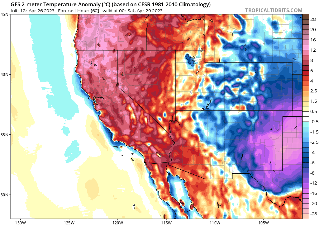
After a winter and early spring that were characterized by remarkably cold conditions across the entirety of California, this week could not feel more different. Above-average temperatures have been the rule in most places, and this early season heatwave is expected to ramp up further over the next few days before peaking around Friday in most spots. Temperatures will be unusually warm both day and night, with some daily record high temperatures (and record warm overnight minimum temperatures) will likely occur across portions of Northern California. This will be true in the higher mountains, as well, where an absolutely enormous snowpack still remains.
As should come at no surprise, this early season heatwave will dramatically accelerate snowmelt from today through the weekend–leading to moderate flood concerns in mountain watercourses themselves and greater concerns in the valleys downstream (and the Tulare Lake Basin, in particular). Flood watches for snowmelt-related inundation are up for both the western and eastern slopes of the southern and central Sierra; Yosemite Valley in Yosemite National Park will be closing due to anticipated flooding this weekend (though I do expect the level of inundation up there to be disruptive rather than destructive–so hopefully it’ll be a relatively short closure). A more serious situation continues to evolve in and near the Tulare Lake Basin, since the rate of inflow into an already flooded area will spike later this week–causing yet more problems, though the details remain somewhat hard to predict. There are vast tracts of agricultural land, as well as multiple small to medium-sized towns in the area, which will be exposed to a continually escalating flood threat for weeks to come.
Snowmelt flood risk from this pulse will likely peak this weekend into early next week before subsiding somewhat (see the next section). But I do want to point out that this will not be the last or necessarily largest flood peak from snowmelt this season–current expectations is that we can expect snowmelt to peak around late May or early June, so we could well have at least 4-6 weeks before that happens (and places like Tulare Lake will have problems for much longer than that). Any additional early heatwaves or major warm rain events between now and early June would still have the potential to cause even greater challenges.
Cut-off low pressure system next week will bring cooling trend but also possibility of notable NorCal thunderstorm outbreak
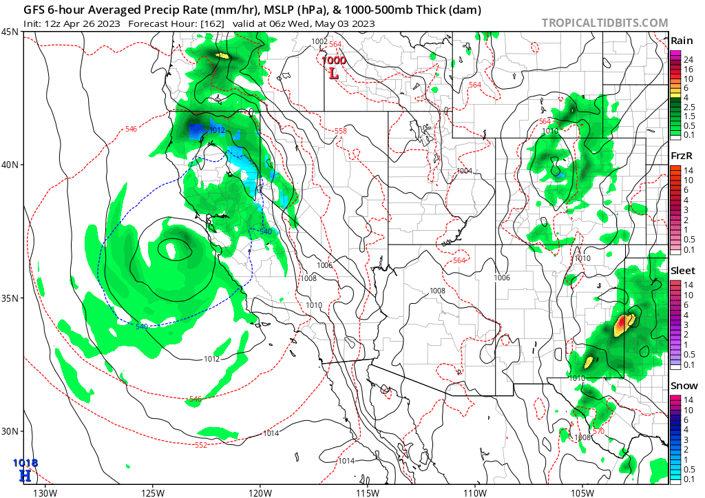
Next week, there will be yet another dramatic shift in the prevailing weather regime over California as a cut-off low pressure area sets up shop over or just west of NorCal by next Tuesday. The most immediate impact will be a dive in temperatures to somewhat below average levels once again, although it’ll be less pronounced than recent cold spells. Windy conditions are also likely as a relatively dry cold front moves through initially. As the cut-off low lingers over or near NorCal for multiple days, however, it now appears it’ll pick up some Pacific moisture and that, combined with considerable atmospheric instability, could lead to some pretty interesting weather across much of central and northern CA from about Tuesday through Friday next week.
The devil’s always in the details with cut-off lows, so it’s hard to make a specific prediction 6-7 days in advance. But I will say that the current placement of the low pressure system, combined with pretty cold air aloft for this time of year and least a modest Pacific moisture source, immediately suggests to me the potential for a fairly significant convective event (i.e., showers and thunderstorms) across the northern half of the state during this period. In fact, some model runs are already depicting around ~zero C with surface temperatures near or above 60–suggesting very steep low-level lapse rates amid a conditionally unstable atmosphere (some model runs are depicting wide areas of 500-1000 J/kg of CAPE, which is a lot in CA). Additionally, some runs depict the low remaining in such a position such that upper-level winds would favor upper-level divergence over central CA–adding some dynamical support into the mix.

What does this all mean? Well, widespread significant precipitation remains quite unlikely at lower elevations (though could be somewhat more widespread in the NorCal mountains). But pattern recognition, plus the lateness of the season and the strong early May sun angle, suggest that this will be a favorable pattern for scattered thunderstorms over NorCal (especially the mountains and the Central Valley /foothills, but perhaps elsewhere too). It’s also the kind of pattern that might become favorable for yet more supercell thunderstorms (with associated larger hail/brief tornado risk) in the Central Valley at some point next week, too (we’ve already seen a lot of that this year!). So this is one of those “storm” events that may not be very significant in most places (in fact, some spots could remain entirely dry), but could be rather dramatic locally.
Although the focus of this event currently appears to be the northern half of CA, recent model runs do suggest the low may move far enough south to bring a possibility of scattered showers/thunderstorms to much of SoCal as well later next week. So…stay tuned!
Overall, the cooler temperatures next week will decelerate snowmelt once again from its faster pace during this week’s heatwave. But there will also be some potentially substantial precipitation in some Sierra basins next week, and that could fall mainly as rain in many areas (though would still be snow at the highest elevations). So I expect high river flows will continue next week, despite cooler temps, though they should generally be somewhat lower than this week. One thing to keep an eye on is whether any persistent thunderstorm downpours develop over any of the smaller watersheds in the Southern Sierra that still have a huge amount of mid-elevation snow–that could cause greater-than-anticipated problems locally or downstream if it were to occur.
El Niño keeps cookin’, and global ocean temperatures break heat records by huge margins
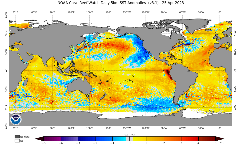
El Niño is now rapidly developing in the tropical Pacific Ocean, with remarkable and even record-breaking ocean surface temperature anomalies now emerging near the coast of South America (Peru). Additionally, the *entire* subsurface of the tropical Pacific from essentially the International Dateline eastward to South American is now much warmer than average–suggesting that there is a whole lot of anomalously warm water getting ready to surface during the next round of westerly wind burst activity (which, right on cue, is expected to ramp up during May). There is much chatter in the oceanographic and climatological communities at the moment regarding the amount of heat that has likely been sequestered in the subsurface ocean by a rare consecutive “Triple Dip” (three year-long) La Niña event against the backdrop of a warming climate–which mostly relates to the elevated possibility of a strong (or very strong) El Niño event this year. In other words: it’s not just that there’s a high likelihood of El Niño conditions of some magnitude this year (which there is), but there’s also a moderate but growing likelihood of a remarkably strong event later in 2023.

What do the models say? Most are now predicting an El Niño event ranging from moderate to strong (or even record-breaking) magnitude, peaking late next autumn or early next winter. There’s still a wide range of outcomes possible at this early juncture, but as the median outcome is getting close to “strong El Niño,” I do think it’s worth having this conversation now. If this happens, there will be significant implications for California weather beginning around mid-summer (when the presently unusually *cold* ocean temperatures may rapidly shift to unusually *warm*, disrupting what will otherwise likely be a robust coastal marine layer in May/early June, and raising the likelihood of coastal humid heatwaves) and then through next autumn and winter (it would likely increase the odds of an unusually wet season next Water Year).
I will, of course, be watching this closely in the coming weeks and months; you can follow that conversation here, on Twitter, or via my now relatively frequent live virtual “office hours” on Youtube.
Discover more from Weather West
Subscribe to get the latest posts sent to your email.