A fairly dramatic shift to cooler and wetter conditions
In recent days, much of California saw a pretty abrupt shift from dry and anomalously warm conditions to damp, windy, and much cooler conditions. Rainfall was fairly widespread in NorCal though not especially heavy; most of the Sierra Nevada has experienced some solid early season snowfall as well (though would not necessarily call it heavy…yet). Some locations saw isolated thunderstorms and small hail–an indication of relatively cold air aloft and a modestly unstable atmosphere. And this first system is–fortunately!–a preview of more similar weather to come over the next 7-10 days.
Additional (beneficial) cold storms on the way, with heavy Sierra snowfall likely
In the short term, this is really one of the best forecasts you could hope for if you don’t like drought and extreme autumn wildfires. The upcoming rain and mountain snowfall should deliver some much needed water to parched ecosystems, and effectively kill off fire season in northern and central California once and for all (absent another extraordinary mid-winter storm curtailment like last year). It will also (most likely) bring substantial benefits to SoCal, greatly mitigating fire season there as well (though the background likelihood of fire risk reemerging during Santa Ana wind events later in winter is always higher down south vs. up north).

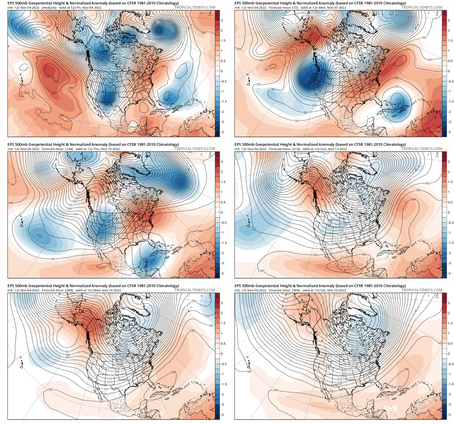
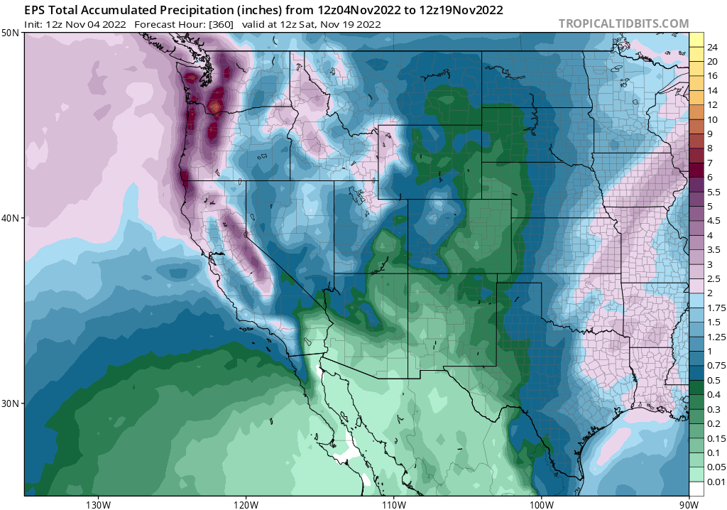
What will these storms actually bring? Well, it appears that the conveniently spaced-out parade of good old Gulf of Alaska systems will continue for at least the next 7-10 days or so. None of these storms currently looks exceptionally strong, so while they’ll bring widespread moderate rainfall (from slightly less than an inch to around 3 inches of liquid equivalent up north, and up to around an inch in SoCal) and modest winds to lower elevations, there’s little or no substantial flood or wind damage risk. These storms will be a bigger deal in the Sierra Nevada, though, at least from snowfall perspective. 1-2 feet, and locally 3+ feet, could accumulate between Sunday and Tuesday (with the most at the highest elevations, as usual). And snow levels will slowly fall to relatively low elevations–starting out around 6,000 feet, but lowering to near 2,500 feet by Mon/Tue. That means that relatively heavy snowfall is possible even down into the upper foothills. All of this means that there will likely be major travel challenges this weekend over the major passes, and perhaps down to lower elevations in some spots as well.

This cold and unstable pattern will bring much below average temperatures statewide (and, indeed, across the entire Western U.S. in a substantial reversal from recent weeks/months!). Along with the rain and mountain snow, there will likely be episodes of isolated thunder/small hail storms at lower elevations as spokes of vorticity move ashore within the broader offshore trough axis amid a conditionally unstable atmosphere. All in all, a nice and active weather pattern is in store for essentially all of California over the next 7-10 days, with few hazards associated with it except for road travel (especially in the mountains).
Thereafter, there is a little more uncertainty–ensembles are presently suggesting mixed signals regarding a possible return to less active/drier and warmer conditions by mid-November.

Pronounced La Niña still a key driver for upcoming winter
Autumn and even early winter conditions really don’t tell us much about what the Water Year will look like overall–though wetter conditions early on do give a bit more of a buffer if things do dry out later. And that’s still a very plausible possibility for the 2022-2023 season: La Niña’s still going strong in the Pacific, and has even strengthened a bit in relative terms in recent days. A persistent North Pacific ridge is still very likely for most of the coming winter. But the question, as always, is where *exactly* does the ridge axis set up? If it’s far enough west, then California could continue to see cold storms like the one’s we’re experiencing now from early to mid November. But it’s far enough east, we could see another year in which things dramatically dry out right near what would normally be “peak season.” Right now, I’d still put the odds at about 2:1 to 3:1 that the latter will be closer to reality–and that we’ll still see a drier-than average Water Year overall for most of California and much of the Colorado River basin. Will be interesting to see the new suite of seasonal model products when they come out early next week, but for the moment my seasonal expectations remain essentially the same as in recent discussions. That said, I’m glad we’re getting some solid cold storms in November!
Announcing (soft launch of) the new Weather West YouTube channel!
For a variety of reasons, I’ve decided to expand my weather and climate science communication to YouTube. This will be my first foray into producing video-format content, so I appreciate your patience as I figure things out! My goal is to create a mix of content there–including informal “ask me anything”-type sessions on weather and climate, occasional more highly produced videos on climate change and related topics, and probably episodic and event-driven analyses of extreme events in near real-time (these will be rare, and focused on exceptional weather/climate events–especially in California and the American West). I’ve soft-launched the channel this week a bit earlier than expected, so at the moment there’s only an introductory video (plus a playlist featuring some of my public presentations and media appearances), but stay tuned for some additional short videos in the next month or so and then a formal channel launch in early 2023. As a reminder, I’m also still planning to remain on Twitter for the foreseeable future.
Discover more from Weather West
Subscribe to get the latest posts sent to your email.