“March Mitigation” commences as unusually cold late-season storm sequence arrives
Recent precipitation has begun to reduce enormous seasonal deficit, but still long way to go
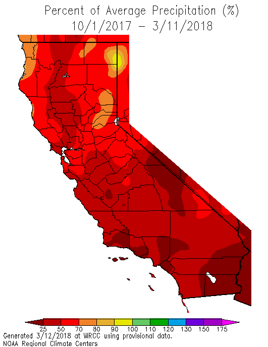
In my last post, I mentioned that upcoming storms would (finally!) start to chip away at the huge seasonal precipitation deficit that has accumulated this year throughout California–but that this storm series would be far from a “Miracle March.” So far, that expectation has largely been borne out: fairly prodigious multi-foot snow accumulations did occur throughout the Sierra Nevada, and the overall amount of water stored in the statewide snowpack doubled nearly overnight. But it’s important to consider the absolute numbers here: snowpack was so low going into the most recent storm sequence that snow water equivalent doubled from 18% to around 37% of average–meaning that there’s still more than 60% less snow in the mountains than has historically been the case this time of year. More broadly, precipitation to date is still well below average everywhere in California, and is still less than 25% of average across large portions of SoCal. In other words: recent rain and snow have been highly beneficial, but we still have a long way to go.
“March Miracle” still a high bar, but maybe “March Mitigation” is good enough?
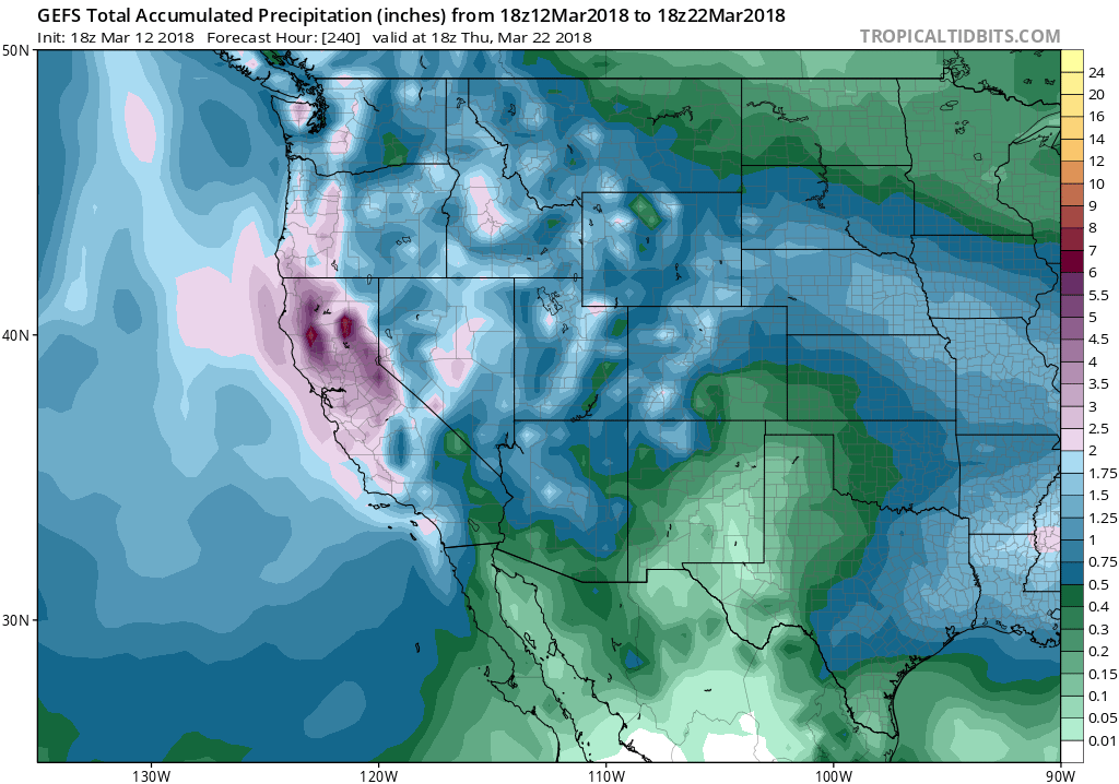
Well, I do have some good news to report: there’s quite a bit more rain and snow on the way! A renewed series of storm activity is expected to bring widespread precipitation over (at least) the next 7-10 days, and the potential is there for a rather strong storm or two in the mix. Ensemble forecasts are suggesting that precipitation over the next two weeks could be quite substantial, with several inches possible in some coastal spots and 6 inches of liquid equivalent in the favored Sierra Nevada watersheds. These are not exceptional totals, but they are definitely above average for a two week period this late in the season. Importantly, there will be quite a bit of cold air associated with this precipitation, and so snow levels will once again be low enough for most of this water to fall in frozen form above about 4000 feet (and locally lower). That’s great news from a snowpack perspective, as it appears that this storm sequence could cumulatively drop several new feet of snow in some places (perhaps nearly as much as the last event at the highest elevations).
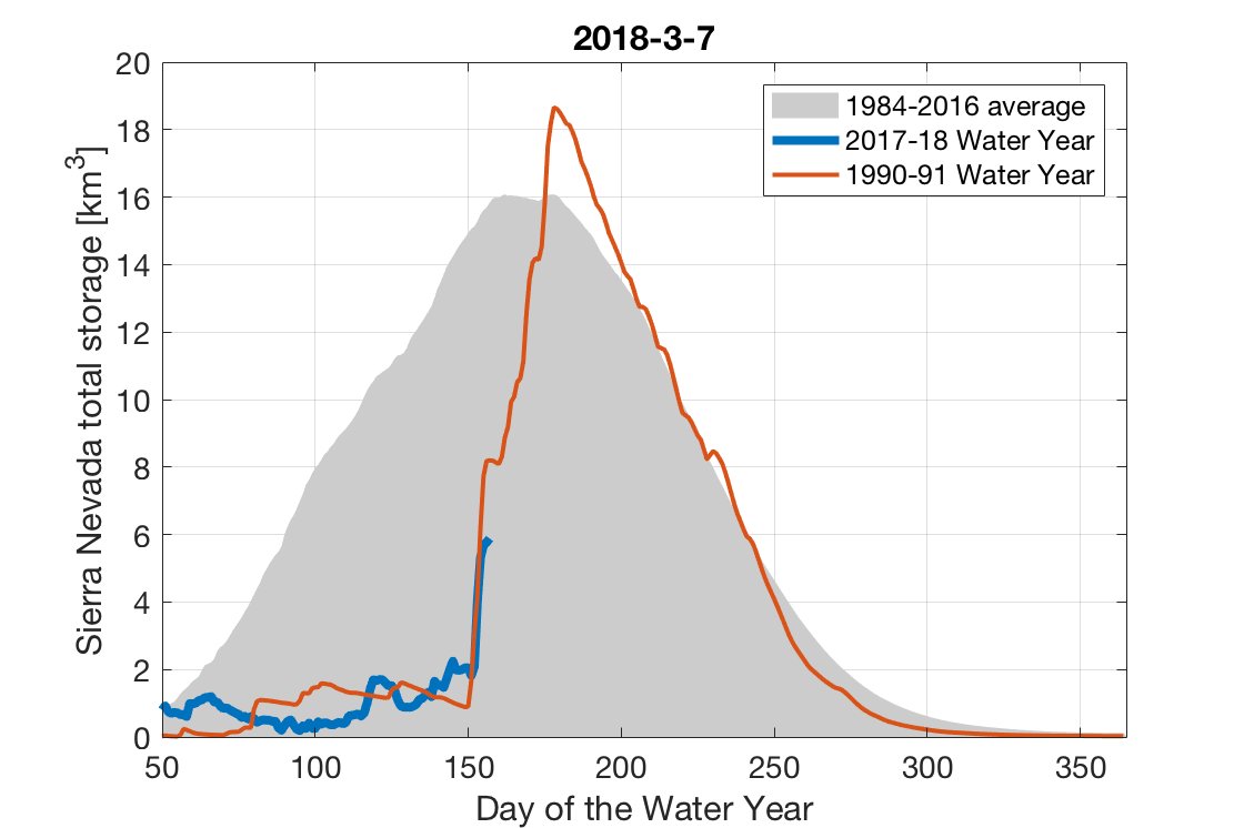
Worth noting when folks talk about a “Miracle March,” however, is just how exceptional that eponymous 1991 storm sequence really was. As I’ve recently discussed, we probably shouldn’t be using that event as a benchmark for late-season turnarounds in California–despite the new storms in the forecast, there still aren’t signs of a repeat of that magnitude. (This is why I’m borrowing a term from a Weather West reader and calling the upcoming event a “March Mitigation” (in a drought sense). I think the attached figure speaks for itself:
Period of persistent storminess on the way
In the previous post, I discussed how a recent “sudden stratospheric warming” event and subsequent split of the stratospheric vortex was a primary driver of our unexpected (and fortuitous) late-season shift to a wetter and colder pattern in California.
Well, the polar vortex (in the stratosphere) has now re-formed, but the tumultuous legacy of its earlier collapse is still being felt in the troposphere (i.e. the lower part of the atmosphere where we live). A wavy, stuck-in-place jet stream pattern is still keeping some places very cold (the European “Beast from the East” is returning this week) and other spots exceptionally warm (the Arctic just rounded out its record warmest winter, coinciding with record low sea ice). All of this is to say: winter’s last gasp is actually shaping up to be pretty impressive in some places this year.
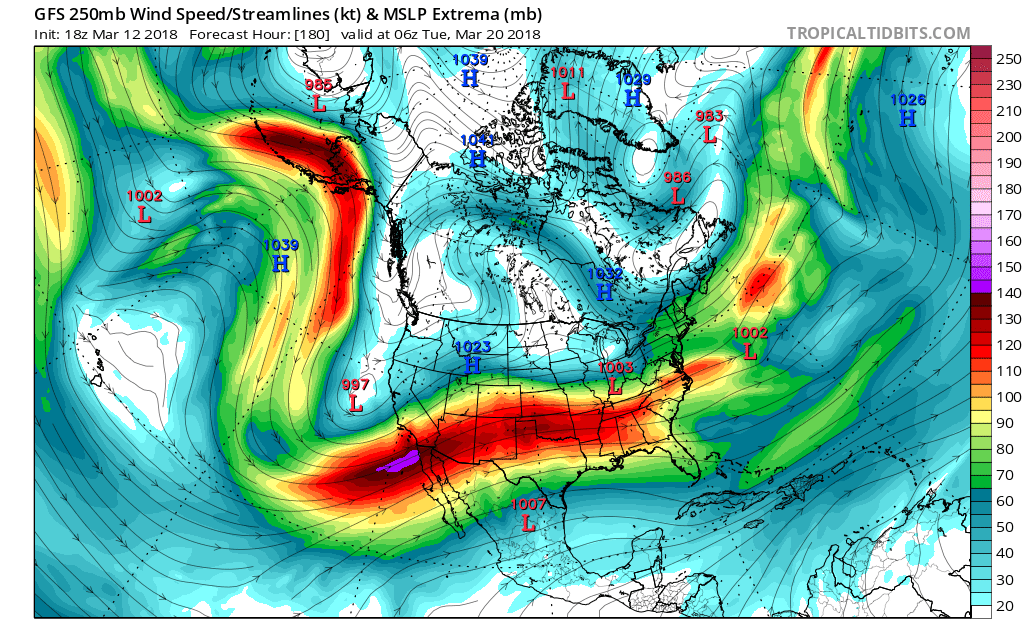
There are still substantial inter-model differences regarding how the pattern evolves over the next week or so, but the big picture is pretty clear: a persistent trough will anchor itself just west of the West Coast, allowing surface lows to spin up/deepen off the coast and fling waves of storm activity over the Golden State. Eventually, this fairly deep surface low itself will move eastward and inland; when this happens, it may spell an end to the stormy pattern. But we will probably see a good 7-10+ days of periodic rain and snow. Given the strong mid-March sun angle and impressively cold air aloft, I would expect to see at least scattered thunderstorm activity at times, especially in the Central Valley and more generally across NorCal (though SoCal could see some activity at some point, too). Timing which days will see the most intense rainfall is impossible at this point (though it’s worth noting that the Sierra Nevada may essentially see multiple consecutive days of nearly uninterrupted light snowfall, with a few heavy bursts).
Southern California is a bit more of a wildcard, precipitation-wise. Recent model solutions have oscillated wildly between pretty mundane outcomes (occasional light to moderate rain) and some pretty eyebrow-raising ones (multiple days of widespread and heavy-at-times rainfall along with thunderstorms). Either scenario is possible at this point, though I’d lean toward the less wet one. One concern, especially if the wetter scenarios pan out, is that the Thomas Fire burn scar may be at risk of renewed flood/debris flow activity. There are already (once again) mandatory evacuations in effect in Santa Barbara County in advance of tomorrow’s rain. As always, I’d advise people to heed the advice of local authorities. But at the moment, projected storm activity later this week and into next week has considerably higher potential to cause problems than tomorrow’s event (so hopefully “evacuation fatigue” won’t set in before then).
All in all, these storms will probably do more good than harm (especially if Santa Barbara and Ventura can escape any significant debris flow issues). At a minimum, it does appear that the Sierra Nevada will end March with a semi-respectable snowpack–even if it remains well below the historical average. Fingers crossed!
“March Mitigation” commences as unusually cold late-season storm sequence arrives Read More »