Significant pattern change, though not necessarily significant precipitation, across California this weekend
Anomalous to record-breaking autumn warmth in recent weeks (yes, yet again)

The last two months have proven to be yet another extraordinarily warm/hot period for much of the West, including most of California and essentially all of the Pacific Northwest. Although coastal California is no stranger to very warm temperatures even late into October during offshore wind events, seeing widespread sustained heat like this (even as far north as British Columbia and even at high elevations) has been exceptionally rare to unprecedented historically. Folks up in Seattle and Vancouver have attested to being “seriously weirded out” by “California-like” warmth and dryness at a time of year that is nearly always quite wet and often cold and dreary (in fact, the rainy season actually peaks in November in some parts of B.C.!). The warmth in California has been somewhat less historic, although still conspicuous.
Conditions have also been much drier than usual (record dry, in fact, in many spots) across the Pacific Northwest, where very unusual late-season wildfires have continued to burn into mid-October and creating a public health crisis due to the multi-week persistence of dense smoke near the surface (sound familiar?). Fortunately, a change in the weather today finally pushed most of the smoke out of the region and has likely dampened fires considerably.
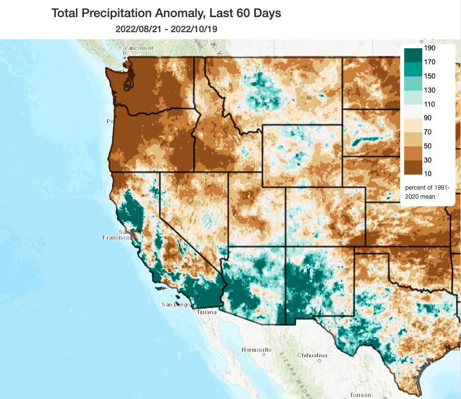
Over California, precipitation over the past two months has been a bit of a mixed bag. Some areas saw *record* wet conditions in September (a decidedly low bar, to be sure, but it was certainly enough to short circuit fire season for a time and yield some beautiful smoke-free skies for a few weeks–and for that, I think a lot of folks are grateful). But the effects of that early season precipitation are fading, and it’s also true that not all places benefited from that September rainfall. The convective nature of those (locally heavy) showers and thunderstorms brought localized minor flooding to some places but left others high and dry–meaning that levels of landscape and vegetation dryness now vary considerably from one county to the next (and why some areas will see high fire risk this weekend, but other spots are even seeing some new green grass sprout up).
Pattern change this weekend: much cooler, windier, and some localized precipitation in lucky few locations
Fortunately, the prolonged period of much warmer than average temperatures is likely in the rear view mirror. A much cooler and more unsettled pattern will develop this weekend across California thanks to a modest “inside slider”-type low pressure system. This system won’t be completely dry–it will probably generate some showers along the far North Coast and maybe also some light showers over the Sierra Nevada and even parts of far SoCal. But most of Central and Northern California will remain completely dry into early next week despite the passage of this system.
What everyone in CA will notice, however, are the increasingly strong/gusty N/NW winds and much cooler temperatures. Although this does not appear likely to be an extreme offshore wind event, it will generate moderate to locally strong gusts in some areas–particularly along/near the coast in the San Francisco Bay Area, in parts of the Central Valley and foothills, and the Sierra Nevada. Although winds will not be extremely strong and relative humidity will only be moderately low, vegetation has dried out considerably in many areas since the September precipitation and so there will be a significantly elevated fire weather threat (though probably not an extreme one) in some areas. PG&E has mentioned the potential for Public Safety Power Shut-Offs in some areas, although I doubt they will be especially widespread with this relatively moderate pattern. Highest risk would probably be in areas that did not see significant Sep precip and are also not expected to see measurable precip this weekend.
Still hints of slightly wetter pattern toward late Oct/early Nov, but models “kicking the can”
For some days now, multi-model ensembles have been suggesting the relatively high potential for more widespread rainfall across at least Northern California 7-10 days in the future. Well, two weeks have passed…and that elusive wet shift is still 7-10 days in the future. (Although it has been worth noting that at least 20% of individual ensemble members have been depicting dry conditions this entire time–another example of why it’s important to consider the full ensemble, not just the individual operational model runs that bounce around from one prediction window to another.) This kind of “kicking the can down the road” behavior is really not that unusual or surprising during the autumn transition season–although that can make it difficult to ascertain when a true shift is actually on the horizon. At the moment, it still appears that some light to locally moderate precipitation may be possible across NorCal by late Oct or early Nov, but I’m a bit skeptical. Either way, even the ensemble averages suggest that below average precipitation is likely to persist across most/all of California for the next 10-14 days–so even if some modest precipitation does materialize there are currently no signs of anything big. The thing to look out for will be any strong north/offshore wind events in the next 7-10 days before widespread significant precipitation occurs (since that would pose an elevated fire weather risk). Currently, none are on the horizon except for the modest one this weekend–but that is subject to change this time of year.
Research highlight: Atmospheric river temperatures and the Pineapple Express
Although (unfortunately) there are no atmospheric rivers on the horizon at the moment in California, some of our latest research on these moist plumes of concentrated water vapor transport was just published. In this work, which was led by my colleague Katerina Gonzales, we find that ARs with lower origin latitudes, higher levels of vertically integrated water vapor transport (IVT), and longer lifetimes tend to be warmer than their counterparts at landfall–potentially leading to enhanced hydrologic impacts (because warmer ARs produce more rain vs snow at higher elevations, leading to greater immediate runoff). We also, for the first time, systematically confirm that so-called “Pineapple Express” atmospheric river storms–those with origins in the subtropics near the Hawaiian Islands–are indeed both warmer and moister at landfall than other ARs (especially during the winter months). The paper itself is open access, and you can also check out the summary thread by Kat below:
