Widespread rain in SoCal to temporarily alleviate fire concerns by Sunday; SoCal drought still likely to expand rest of winter
Extraordinarily sustained winter fire weather episode continues in SoCal through Saturday, but dramatic shift to come
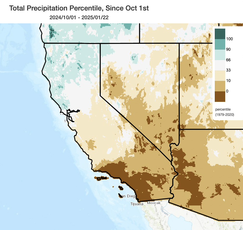
Southern California is now well into its driest start to the ostensible “rainy season” on record, and this week we’ve been topping things off with single-digit humidity and balmily warm temperatures. Moderate to strong offshore wind conditions have continued periodically since early January, though have not eclipsed the (extreme) Jan 7-8 event. Nonetheless, there has been a steading an increasing pace of additional wildfire activity throughout Southern California and also Baja California; most of these fires have remained on the smaller side but several have escaped initial control to burn thousands of acres and force substantial evacuations in new areas not originally affected by the early January fires. For its part, Northern California has been drying out too–though here there is still the beneficial legacy of the (extremely) wet start to the season back in Oct-Dec and so soil/vegetation conditions are far from critically dry. Even here, though, there have been some small and slow-moving vegetation fires in recent days; not especially surprising considering from a wildfire risk perspective compared to southern CA, but a testament to how much things have changed since the record-breaking atmospheric river events back in late 2024 in the very same region.
Rain, at last, in Southern California: Widespread and locally heavy showers Sun-Mon in most areas (plus mountain snow)
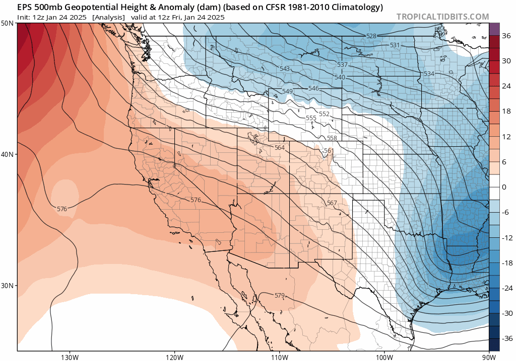
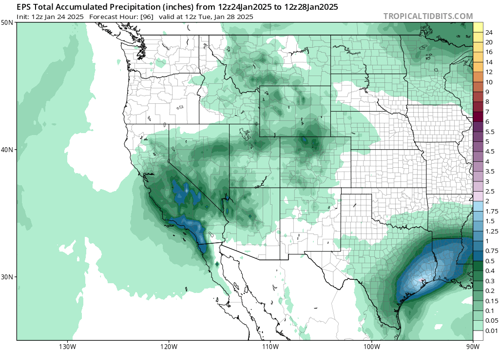
In some parts of Southern California, less than a tenth of an inch (0.10 in.) of rain has fallen since last May (2024). Most of those places will, finally and at long last, see a soaking rain this weekend (Sun into Mon). This will be delivered not by a traditional west-to-east moving Pacific storm system but instead by yet another “retrograding” (northeast-to-southwest-moving) cut-off low pressure system sliding down the spine of the Sierra Nevada before moving westward to a position over or just west of the SoCal Bight by Sunday. This position will be just far enough west to pick up enough local moisture from the Pacific, when combined with decent atmospheric instability contributed by very cold air aloft, to generate widespread convective showers and probably at least isolated thunderstorms. While it certainly won’t rain continuously between Sun and Mon, there will be occasional showers–and they could contain some hefty downpours. The showery and convective nature of this system means there will likely be “winners and losers;” some areas will see considerably more than the average amount, and a few spots could stay nearly dry. But in general, I’d expect to see around 0.3-1.0 inch at lower elevations, and 0.5-1.5+ inches in the mountains of Southern CA. Above 4,000 feet, most of that precipitation will fall as accumulating snow (with locally heavy amounts). Given what has transpired recently, that is certainly respectable.
Some scattered showers may be possible as far north as the San Francisco Bay Area/Interstate 80 corridor and along the Central Coast; there remains some uncertainty regarding the northwestward extend of the precipitation this weekend from this retrograding low pressure system.
Mountain snowfall is likely, though it will be mostly light; the Sierra Crest will likely see at least a few inches of powder (including Tahoe Basin); the higher mountains of SoCal could see quite a bit more than that–locally 6-12+ inches at the highest elevations, with a dusting possible along Central Coast and SoCal mountains down to 3,000 feet or so (which even includes the upper reaches of some recent wildfire burn areas). Just about any location in Southern California could see some small hail from isolated thunderstorms later this weekend, as is often the case during cold/unstable conditions brought about by cold cut-off lows.
One major question has been whether this weekend’s system could bring a risk of dangerous debris flows, mudslides, or flash flooding to recent wildfire burn areas. There is virtually zero risk from a system like this outside of such zones, since overall precipitation will not be that extreme and antecedent conditions have been exceptionally (even record) dry. But in/near, and immediately downslope from, recent wildfire burn areas–especially the Jan 2025 fires (mainly Eaton and Palisades though also others) but also the large fires that burned at higher elevations back in Sep 2024 (Bridge, Line, Airport)–very recently burned slopes will be highly susceptible to increased runoff rates and debris loading compared to what would otherwise be the case. Given the likelihood of at least isolated thunderstorm activity with heavy downpours, there is at least a slight risk of debris flows in the recent fire zones; if the wetter ensemble members verify, this may be closer to a moderate risk. The NWS has already hoisted a Flash Flood Watch for the burn areas; I would not be surprised to see at least isolated instances of debris flows (which could be quite consequential, given the extreme recency of the fires and the combination of steep slopes/densely populated neighborhoods within and below).
If you live in or near one of these areas, I would pay close attention to NWS forecasts (and especially short-fused warnings) as well as possible evacuation warnings/orders from local officials that may come as a result from the risk of debris flows. (There has not yet been enough time between the fires themselves and this potential rain event to fully assess debris flow risk locally–another challenge with formerly uncommon mid-winter wildfires in SoCal.) These concerns will be present to at least some extent with this weekend’s system, as well as with any future storms the rest of this winter that are capable of dropping even brief/isolated heavier downpours. Remember: when it comes to debris flow hazard, it’s often the rainfall rates that matter more than the total amount–intense downpours, even if they are quite brief, are usually a greater risk that larger amounts of rainfall spread out over a longer period of time.
There are some further concerns, on which I am less qualified to reflect, that rain this weekend could redistribute toxic ash from thousands of burned structures, automobiles, and etc. into waterways and neighborhoods near the fire zones. This is potentially the case, though it’s also true that getting some moisture on the ground will temporarily reduce the quantity of this ash that becomes lofted by gusty winds (so air quality in SoCal should be quite good in general by Sun/Mon–hopefully folks can take a literal breather in that respect, at least).
Overall, I do expect this brief wetter interlude in SoCal Sun-Mon to be highly beneficial in ~95% of cases in terms of (greatly) reducing, for at least a 1-2 week period, regional fire risk and vegetation flammability. There may be some isolated spots where dangerous debris flows could occur, if thunderstorm downpours occur there, in which case this weather could locally be quite harmful. But the reality is that SoCal desperately needs rain at this point–and it is at least plausible that this system will “thread the needle” in terms of delivering a solid region-wide soaking (enough to tamp down fire risk for a while) without causing widespread/severe risk of debris flows (despite the potential for some problems in isolated areas).
“Winter fire season” may not be over in SoCal as drier-than-usual conditions remain likely, but NorCal may see more rain
For the moment, it still looks like this weekend’s system may be a “one and done” type set-up for SoCal. There are some ensemble members suggesting an (even weaker) encore about a week later, but at least as many suggesting that this one modest rain event may be the only one on the horizon (at least across the southern third of the state). Prospects for rain in early Feb are better in NorCal, where there may be multiple opportunities for at least some precipitation. Overall, though, this still looks like a pretty dry pattern for SoCal; in fact, there are already (early/tentative) indications that there could be some more inside slider and offshore wind activity in the first half of February.
At the moment, therefore, I am confident SoCal will see at least a 1-2 week reprieve from high wildfire risk. If this weekend’s rain and mountain snow is not followed up by another substantive rain event within a couple of weeks thereafter, and if we start seeing offshore wind events again (both of which appear possible), than I would not be entirely surprised to see a re-emergence of elevated wildfire risk sometime in February. For now, we’ll just have to see how the pattern evolves.
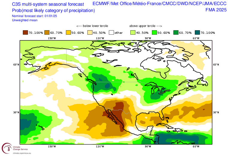
And speaking of the rest of winter, what might it hold? Well, the seasonal predictions suggesting a strong tilt in the odds toward a drier-than-average winter overall across SoCal and the interior Southwest are now almost guaranteed to be validated (given the already accumulated deficit). But moving forward, well…it does look like more of the same, unfortunately: the latest seasonal model ensembles suggest a continued (strong) tilt in the odds toward drier than average conditions across SoCal and the broader Southwest. This, plus the additional anomalously warm-to-hot signal they are also suggesting for later in the spring, suggest that drought will likely re-emerge across this region in the coming months. It is far less clear what might happen in northern California, where record-breaking Oct-Dec rainfall has really helped pad the numbers (and odds for the rest of the season are close to even for below or above average precipitation). But initial indications are that next summer may see a much faster and earlier start to fire season in SoCal and the interior Southwest than has been observed in recent years; in some spots in far southern CA and AZ, 2024-2025 may end up being as close to a year-round fire season as we’ve seen in these parts (with at least some risk of large fires from each month between June the preceding year and June in the present year). We’ll see what happens in the coming weeks and months, but the recent sequence of pronounced and in some cases record-breaking precipitation whiplash in Southern CA has been remarkable (to say the least).