After a long, dry, and very warm January, a cooler & wetter pattern will return to the U.S. West, with partial relief amid record-low mountain snowpack
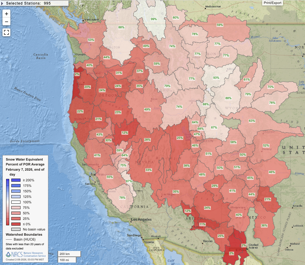
Record warm winter-to-date continues across most of the American West; already abysmal mountain snowpack dips to record low levels in many areas (except…higher elevations in southern Sierra!)
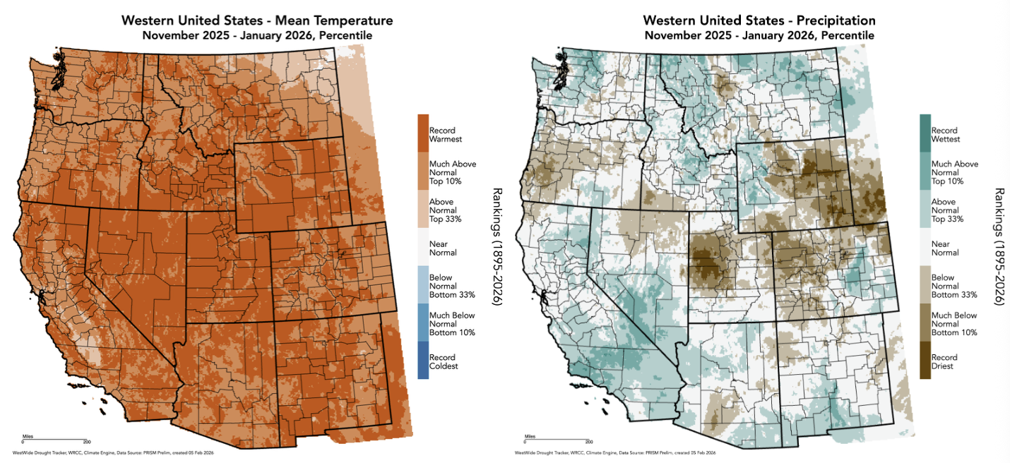
Well, it sure has been a winter to remember thus far across the Western U.S. Astonishing, record-breaking warmth has pervaded nearly entire region (with few exceptions, though one of them being CA’s Central Valley due to two distinct tule fog episodes). Precipitation has been mixed–with a record or near-record wet start to the season across portion of central and southern California and a record dry start across portions of the interior West/Rocky Mountains (including parts of Utah and Colorado). As a result of the nearly universal record warmth, plus regions of low precipitation, western U.S. snowpack has now reached record low levels for February in numerous individual locations; every single western watershed, as of February 7th, had below average snow water equivalent. There are a handful of high mountain regions with near or even above average snow water storage right now–including the highest peaks of the southern Sierra Nevada and northern Rockies–where heavy precipitation earlier this season generated “cement-like” heavy wet snowfall that has persisted despite the anomalous heat. But on balance, snowpack is essentially as bad as it’s ever been in recorded history for the time of year in at least some portion of every single western U.S. state.
Spring or even summer-like warmth has occurred at times all the way from the southern California coast to the Front Range of the Rocky Mountains. Plants, animals, and skiers alike have been exhibiting unusual behavior; tourism in mountain towns has been suffering. And concerns regarding wildfire risk and water supply in the months and seasons to come–especially across the interior West and Pacific Northwest–have continued to deepen.
Meanwhile, much of the eastern U.S. has been muddling through one of the coldest 2-week periods in decades, having experienced some combination of disruptive and even deadly ice and snow storms in the meantime. All of this can be blamed on the multi-week persistence of the “Warm West/Cool East” pattern, characterized by a strong Western U.S. ridge and Eastern U.S. trough, as well as a co-occurring “Warm Arctic/Cold Continents” pattern (wherein a weak tropospheric polar vortex “leaves the freezer door open”–depleting the core Arctic of its normally bitter air at the height of winter and redirecting it equator-ward in a handful of continental regions globally). We’re in the final hours of this particular episode, as in the coming days the overall set-up will largely reverse itself over the continental U.S. (at least for a week or two).
So, the good news is: cooler temperatures, plus rain and mountain snow, are imminent across most of the U.S. West in the coming days. The question is: will it be enough to substantially ameliorate the ongoing Great Western Snow Drought?
A major pattern change is imminent, and it will bring at least partial “snow drought” relief to a good portion of the Mountain West
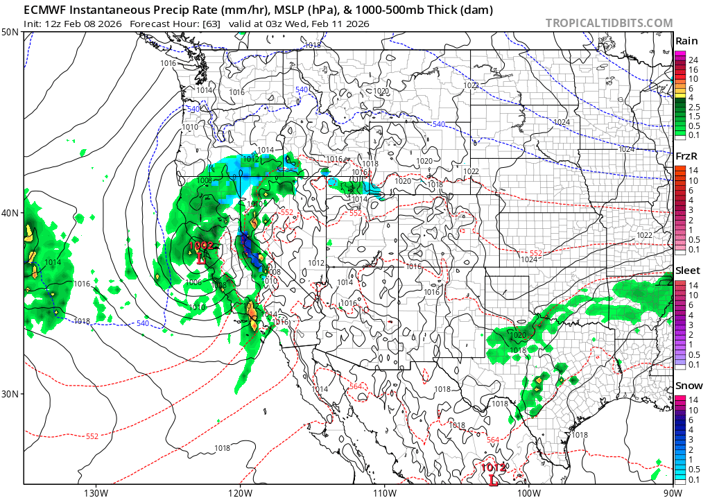
The first in a series of Pacific weather systems will arrive in central California on Tuesday, and it will pack a decent (though somewhat localized) punch. A slowly-deepening surface low will make landfall near San Francisco on Tuesday evening, bringing widespread rain and some gusty winds to much of the state. The greatest impacts will likely be near and south of where the low makes landfall, so including much of the SF Bay Area and I-80 corridor south to the Central Coast. But at least some precipitation can be expected statewide. And while this system will start out on the warmer-than-average side (yes, again!), it does not have a substantial warm subtropical moisture tap so there will be enough cold air filtering in behind the cold front to drop Sierra snow levels to more reasonable/seasonable levels.
This initial system will weaken rapidly after passing over California, missing the Pacific Northwest entirely. While some rain (yes, rain) and higher mountain snow will be likely across potions of the interior West through midweek, much of the region will need to wait a bit longer for more substantial precipitation and cooler temperatures. But they do still appear to be on the near-term horizon.
Uncertainty regarding details, but a stronger storm or two possible in California during upcoming cycle
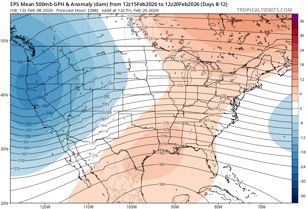
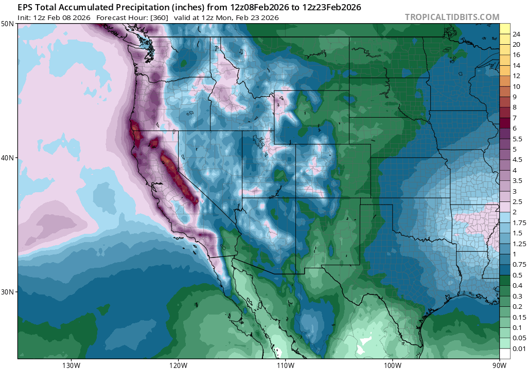
Following the Tuesday system, there is a fairly high likelihood off additional and possibly larger/stronger storms thereafter along the West Coast and across the interior West. The persistent ridge will be replaced, for at least a 7-10 day period, by a quasi-stationary trough along the West Coast or just offshore–a favorable setup for recurring precipitation events. This is a fairly high-energy pattern, with a strong zonal Pacific jet likely to be draped across California for much of the period. That makes pinning down individual storms difficult to impossible at this time horizon, but the overall pattern is one that may support 1-2 strong low pressure systems/associated cold frontal passages, with the possibility of widespread moderate to heavy rain and more localized strong/gusty winds (as well as period of heavy mountain snowfall, and possibly some coastal thunderstorms. More on that below.).
Although this pattern does not appear likely to feature any kind of Arctic/extreme cold airmass, it will still be much cooler than the near-record warmth that has been occurring recently and will likely be cold enough to allow for for respectable snow accumulations across most major mountain ranges in the West over the next 10-14 days. This should be at least enough to keep pace with usual February snow accumulation in these areas, and likely also enough to make up for a modest portion of the season-to-date accumulated snow deficit (especially in places like the central and southern Sierra, which were already doing better in relative terms this season vs. most of the rest of the mountain West). However, I’m not seeing any evidence of a pattern that would come even close to “erasing” the huge and in many cases record-breaking snow deficits that presently exist in many areas.
Thunderstorms & downpours possible with inbound systems due to ongoing marine heatwave and cold air aloft
A major marine heatwave has been occurring across all of California’s near-shore waters in recent months, and it has actually intensified further during January’s calm and quiescent weather pattern (as the lack of storms or strong offshore flow prevented upwelling from occurring). Water temperatures are now 3-5°F above average across a wide area, and locally higher. These are really large anomalies for the ocean, as it takes vastly more energy (more than 4 times as much by mass, or 3,000 times as much by volume) to heat water versus air. Accordingly, these substantial and widespread warm anomalies will have a tangible influence on weather conditions both during this storm cycle and likely for the rest of winter/spring.
The most obvious effect, of course, is warmer near-shore temperatures in coastal areas (I felt this personally last week right along the beaches in LA County, where air temperatures were in the 80s with essentially no on or offshore wind at all). That anomalous warmth will also be “dragged inland” to a limited extent, both during dry periods with onshore flow and also when Pacific storms push air inland. It may cause snow levels to be a bit higher than some models suggest during precipitation, at least prior to or during cold frontal passages (more northerly winds behind cold fronts might negate this effect).
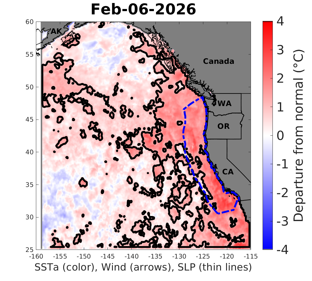
But as noted in the past, warm ocean anomalies of this magnitude can also add additional moisture to the lowest levels of the atmosphere (i.e., the boundary layer) and also contribute some additional potential energy to storms that do arrive on California’s doorstep. This can be in the form of additional convective potential energy (i.e., CAPE) that can contribute to intensified localized downpours and thunderstorm activity, and by adding a bit more “storm fuel” to deepening low pressure systems (via increased latent heat release from increased precipitation rates).
Thus, these warm ocean waters may once again “juice up” the incoming storms a bit, increasing the odds of thunderstorms (which could occur with any of the inbound storms, including Tuesday’s), increase precipitation rates somewhat, and raise snow levels a bit. A portion of these potential effects are likely incorporated into most model forecasts, though there historically tends to be a bit of an underestimation.
High uncertainty regarding the rest of February; more Northern Hemisphere chaos possible
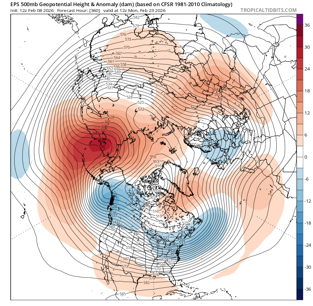
Following this 1-2 week and mostly beneficial storm cycle, there’s a wide range of possibilities regarding what happens next. There are some suggestions of another major polar vortex disruption, which may result in another wavy/amplified jet pattern over the Northern Hemisphere. But even if that happens, there’s no guarantee that the subsequent persistent ridges and troughs will set up in the same positions they did in January. In fact, right now, the ensembles are hinting at the potential for a very strong and persistent blocking ridge developing over the North-Central Pacific near the Aleutian Islands or Bering Sea. If that happens, a large cold air mass will likely develop once again over western Canada. Where will it go thereafter? Well, it all depends on the broader hemispheric pattern. This could mean a re-load of the warm West/cool East pattern once again, or it could even allow some late-season Arctic air to spill southward across portion of the U.S. West. That latter outcome does seem decidedly less likely than the former, but I’ll be keeping an eye on it!
In case you missed it: “Increasing weather and water whiplash on a warming planet: The California experience”
Last week, I was in (anomalously warm) Long Beach, CA for a series of public lectures. In case you missed the main event, hosted by Aquarium of the Pacific, the entire presentation and discussion that followed was recorded live and is now available on YouTube! Thanks again to the aquarium for making this public event so accessible, both in-person and online.
Join me live on YouTube to discuss the upcoming pattern change, inbound storms, and the mountain snowpack situation
I’ll be discussing the upcoming pattern change, and more, on Monday at 3pm Pacific Time. Join me live, and bring your questions!