Drought in California: an quick overview
California is no stranger to drought. Periods of low precipitation show up throughout the historical record–some lasting only a single winter season (most notably 1976-1977), and others lasting the better part of a decade (for example, 1928-1935). Reconstructions of California climate suggest that meteorological droughts lasting multiple decades are not uncommon over the past 1000 years, while there is evidence that dry periods of even longer duration occurred in California’s deeper geological past.
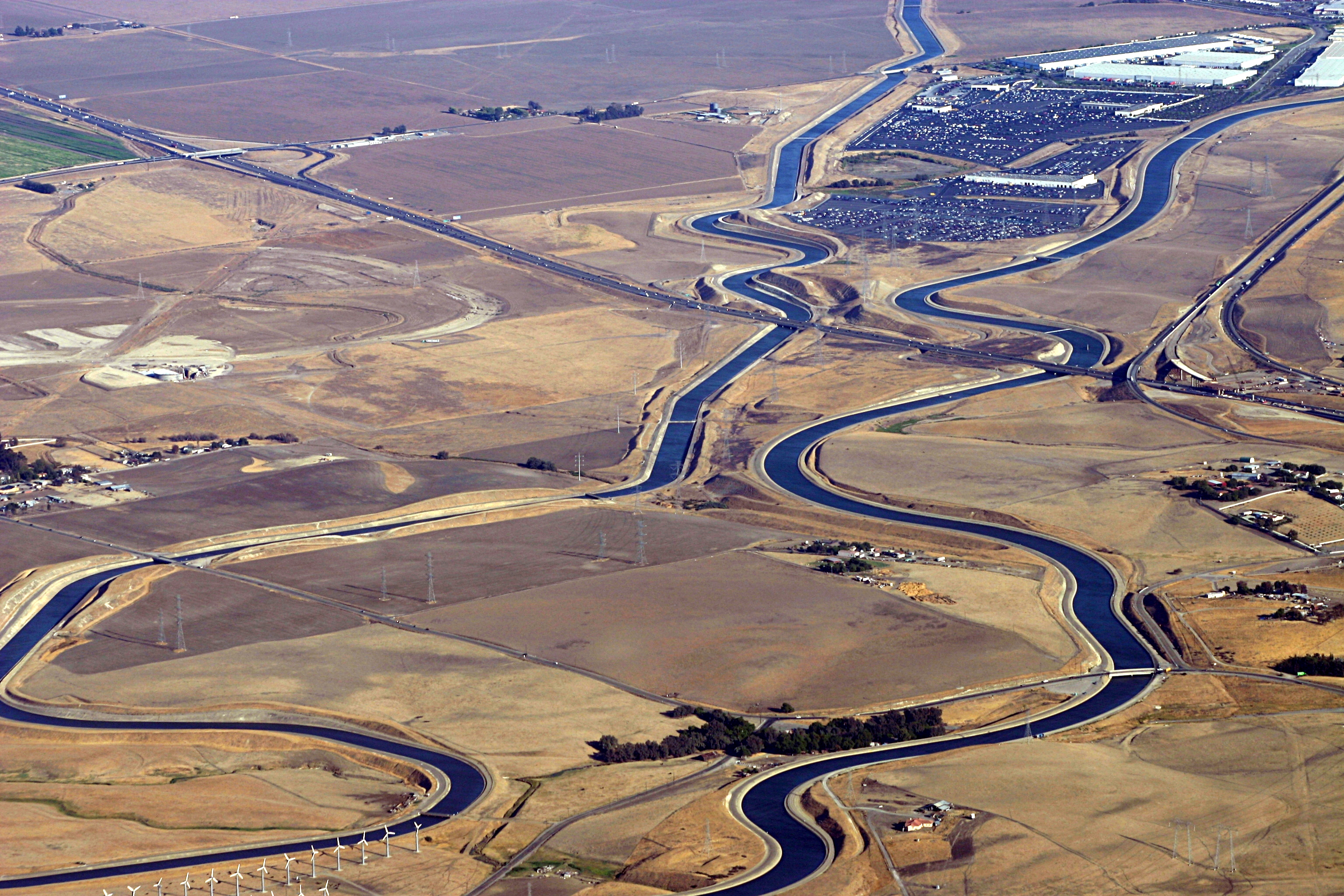
Of course, as many Californians are acutely aware, it doesn’t take a drought of historic intensity to cause serious problems in this state. Since essentially the entire geographic region experiences a qualitatively Mediterranean climate–with strongly seasonal precipitation and a very distinct (but globally uncommon) summer dry season–most of California’s annual precipitation derives from a relatively small handful of major cool-season precipitation events. For this reason, any delay in onset or early truncation of our rainy season (which typically runs from October through May) can quickly result in diminished annual precipitation totals; conversely, the occurrence of just a couple of additional storm events can lead to well-above totals for the year. On top of this large natural climate variability, California’s water supply system is notoriously convoluted and subject to a bewildering array of environmental, legal, political, and usage constraints. These human factors combine with inherent meteorological and hydrological limitations to create a distribution system that can be stressed to its limits even in near-average years.
The current situation
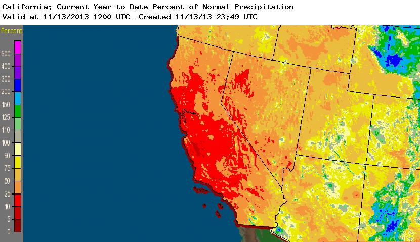
California has now experienced two consecutive dry winter seasons: 2011-2012 and 2012-2013. The 2012-2013 water year was especially remarkable because it began rather early with a series of very intense and moist storms associated with “atmospheric rivers” in Northern California during November but then quickly tapered off, with only light and sporadic precipitation falling for the remainder of the typical “rainy” season from mid-December through May. We’re now in the early portion of the 2013-2014 water year, and so far the extraordinary dry pattern that has been in place since mid-December 2012 is continuing (as of this writing on 11/13/13). In fact, calendar year 2013 now appears to be the driest on record to date–specifically, California has received less precipitation during the period January 1, 2013 – November 13, 2013 than during any other January 1 – November 13 period in at least the past 119 years. This calendar year statistic spans a portion of two water years, which is very unusual for a dry spell of this intensity at any time during the historical record.
Meteorological Analysis
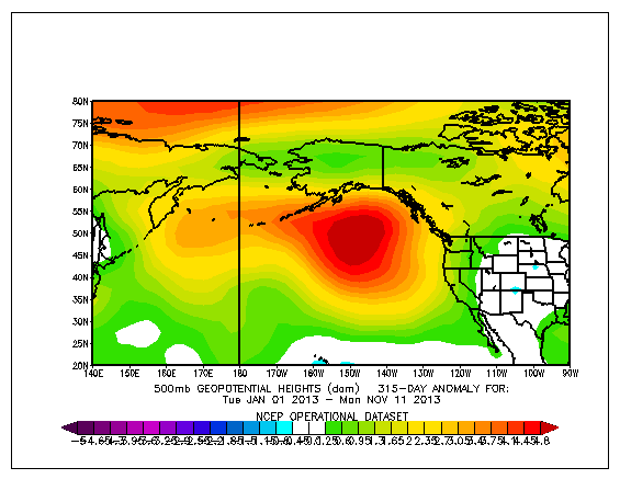
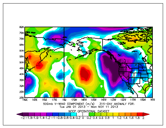
An examination of 315-day (1/1/2013-11/11/2013) departures from average for several different atmospheric variables gives substantial insight into the proximate cause of California’s extreme dry spell. Immediately apparent is the prominence of a broad region of anomalous geopotential height ridging over the northeastern Pacific Ocean. This geographically vast area of unusually high geopotential heights has been extraordinarily persistent over the past 12 months and has also been a common feature in recent dry years (including, notably, the 2011-2012 winter season). Under this huge ridge, sea level pressure also been well above average for the same 315-day period.
Impressive and long-lived wind anomalies at all levels of the atmosphere have been associated with these geopotential height and sea level pressure anomalies in the North Pacific. The jet stream has been diverted well to the north around the northern periphery of the anomalous ridge–all the way up into Alaska, which has been experiencing record warmth and storminess over the past several months. At the same time, a deep anticyclonic flow anomaly is centered on the region of enhanced high pressure, resulting in persistent northerly flow over the West Coast and persistent southerly flow in the Gulf of Alaska (which is likely contributing to some of the ongoing precipitation and temperature anomalies there).
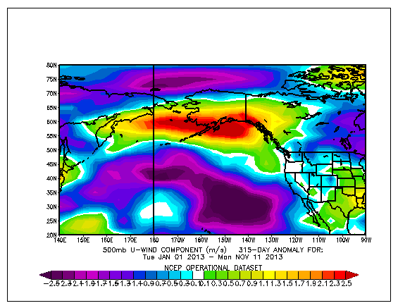
For California, this particular meteorological setup is especially effective at reducing precipitation. High pressure tends to inhibit rainfall by suppressing the vertical motions in the atmosphere necessary for the development of clouds and storm systems, while geopotential ridging acts to shift the storm track northward and to divert existing storm systems away from California. Additionally, a disproportionate fraction of those systems that have made it into the Golden State over the past year or so have had a large over-land trajectory (typically associated with dry “inside slider” low pressure systems, which contain dry continental air rather than moist marine air), a reality that is not all that surprising given the large north-to-south wind anomaly observed.
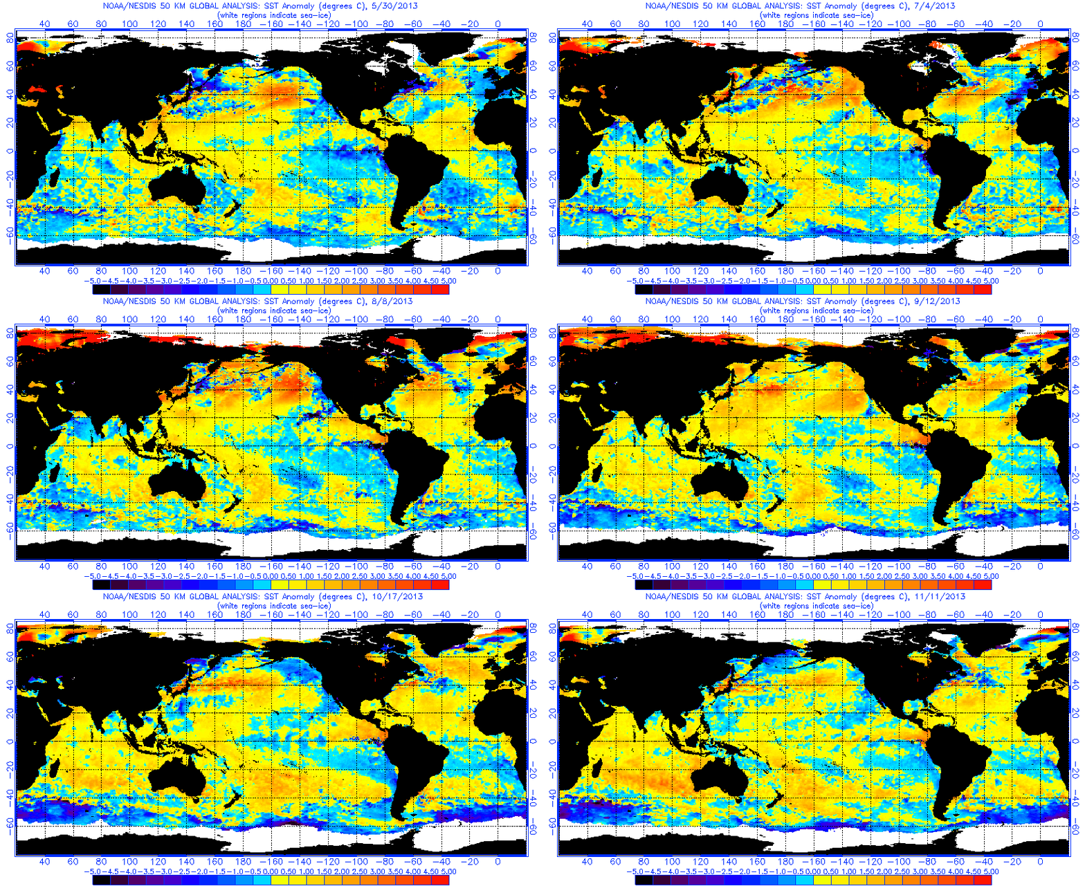
Given the context of this highly anomalous and extremely persistent atmospheric ridging over the northeastern Pacific Ocean, it’s very interesting to note that there has also been a region of strongly positive sea surface temperature anomalies in same the general vicinity for the past 10-11 months. Causality is always tricky to assign in cases such as this one, since it’s entirely possible that the ridging itself has led to warm surface water though decreased oceanic mixing by wind and unusually high air temperatures. On the other hand, ocean-atmosphere coupling is very well recognized in this region on longer timescales (such as the multi-decade periodicity of the Pacific Decadal Oscillation, or PDO), so it seems likely that the anomalous ridging that has led to to California’s extremely dry weather and the North Pacific warm pool are physically linked in one way or another.
When will the current dry spell end?
Unfortunately, there are presently no indications that the persistent northeast Pacific ridging and the associated California dry spell will end any time soon. Medium range numerical forecast models are currently rather consistent in projecting a continuation of the same general pattern for the rest of the month. This doesn’t preclude the possibility of sporadic light precipitation in some regions, but at this point it appears very likely that November precipitation will be well below average statewide. It is difficult to make a prediction for the rest of the water season from early December onward given the lack of a strong ENSO signal. It is worth noting that the PDO is currently in a negative phase, which historically favors reduced precipitation across much of California during ENSO-neutral years. With this in mind, and given how difficult it can be to dislodge deeply-entrenched ridging such as is currently being observed, I estimate that there is an above average probability that total precipitation for water year 2013-2014 will be below normal once again. As we saw last November, though, it only takes a couple of really big storms to fill up the reservoirs, so at this early juncture we’ll just have to wait and see.
Stay tuned.
Update on 11/17
Some light to moderate precipitation now appears likely this week across most of the state as a weak system interacts with a modest suptropical moisture plume. The precipitation this week will probably only be enough to bring us up to normal for the week–that is, in the long run, this week’s rainfall/snowfall will only prevent the already huge precipitation deficit from increasing further. By next weekend, however, a much stronger and broader ridge will build in over the Eastern Pacific, bringing warm temperatures and dry weather heading towards Thanksgiving. While this week’s expected precipitation is much-needed and notable given the recent extreme dryness, we’re probably still on track for the driest year on record.
© 2013 WEATHER WEST