Recent warm and quiescent period ends suddenly tomorrow
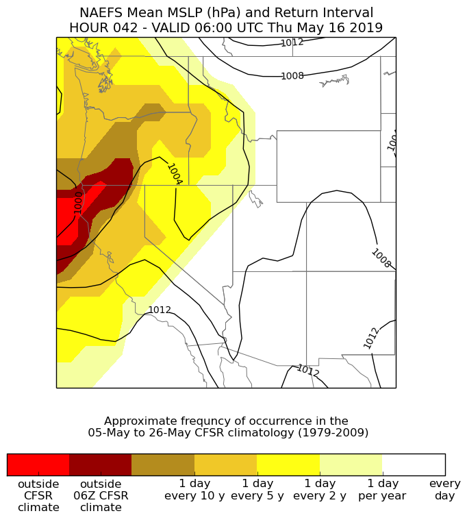
A very warm April and relatively warm start to May–coupled with rather dry conditions throughout the state during that period–will come crashing to an end tomorrow. A rather prolonged period of unsettled, perhaps even downright stormy, conditions are expected across most of California over the next 10 days or so. The suddenness of this pattern change, along with the highly unusual nature of widespread significant rainfall (and mountain snowfall) this late in the season will likely catch a lot of folks by surprise, and will have some substantial impacts for the agricultural sector and those traveling (not to mention those poor souls just starting out on the Pacific Crest Trail).
Widespread rain & mountain snow likely, esp. in NorCal
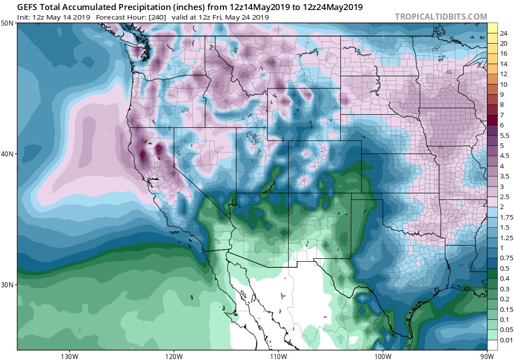
Widespread soaking rains will arrive across the northern half of California tomorrow, and will continue on and off for the next 10-12 days. Significant rainfall is also possible across much of southern California, although that will more likely come from subsequent systems. Over the course of the next 10 days, rainfall accumulations will likely be extremely impressive for late May. Total rainfall of 2-3 inches is likely *across most of NorCal,* including the lowlands; orographically favored mountain areas could see 5-6 inches or even more locally. 10-day rainfall totals will greatly exceed May monthly averages nearly everywhere; this storm sequence could easily set numerous daily rainfall records, and could singlehandedly push many NorCal sites into their top-10 wettest Mays on record. Needless to say: temperatures over the next 10 days should be well below mid-May averages throughout California.
Some good news from a wildfire risk perspective, at least in the short term: widespread rainfall of 2+ inches will likely delay the start of peak fire season by at least a few weeks, and could actually delay the vegetation “curing” (browning/drying) of seasonal grasses and brush across portions of the state. Long-term implications are less clear, though, since wet springs have historically been linked toward more severe fires later in the season across much of the state (as the added moisture allows for increased vegetation growth, which inevitably dries out during California’s bone dry summers. The opposite tends to be true in the denser forests at cooler, higher elevation–where wet springs/snowy winters historically tended to keep the soil column from drying out even in late summer–but that rule of thumb has become a bit dubious as California’s climate has continued to warm). Wet soil conditions will probably also decrease the magnitude of early-season heatwaves in late May and the first half of June (although that’s more relevant for inland areas, as that’s peak “Coastal Gloom” season near the coast).
Non-rain impacts: heavy late-season Sierra snow; local thunderstorms; locally strong winds?
In addition to the widespread (and locally heavy) rain and mountain snow, at least a couple of these incoming storm systems will yield a decent chance of convective activity in the form of thunderstorms. The strong late-May sun angle, combined with quite cold air aloft and some rather impressive dynamic lift courtesy of unusually strong spring low pressure centers, will produce rather favorable conditions. In fact, that’s a pretty compelling list of ingredients for some strong or even severe thunderstorms in some preferred spots, especially the Central Valley. (For you storm chasers out there: I would not be too surprised to see some rotating mini-supercells at some point, given the presence of cyclonically curved jet overhead and other favorable parameters). It’s hard to time the arrival of peak thunderstorm likelihood during this active period, but there will probably be at least 2-3 distinct periods of convective activity over the next ~10 days. Most of this activity will be confined to NorCal, but the models have been hinting that one storm system next week could dig quite far south and increase the risk over SoCal as well.
Meanwhile, these systems will also be notably cold for this time of year, and will likely bring widespread significant snowfall to the Sierra Nevada. Heavy (1-2+ feet) snow accumulations are likely above 8,000 feet, but some travel-disrupting snowfall is likely down to Lake Tahoe elevation or even lower (perhaps as low as 5,000 feet locally). As the local NWS offices have pointed out, May snowfall is not actually all that rare in California’s mountains–but late-May accumulations of this magnitude are a bit eyebrow-raising (especially given the highly anomalous warmth in recent spring periods).
Finally: wind. Strong winds from a Pacific storm system are quite rare in May, yet that’s exactly what some models are suggesting for early next week. It’s still a bit early to get too excited, but given the lateness of the season and the fact that most trees are now fully leafed out, even a moderate windstorm could have significant impacts.
More like March than May: what the heck is going on?
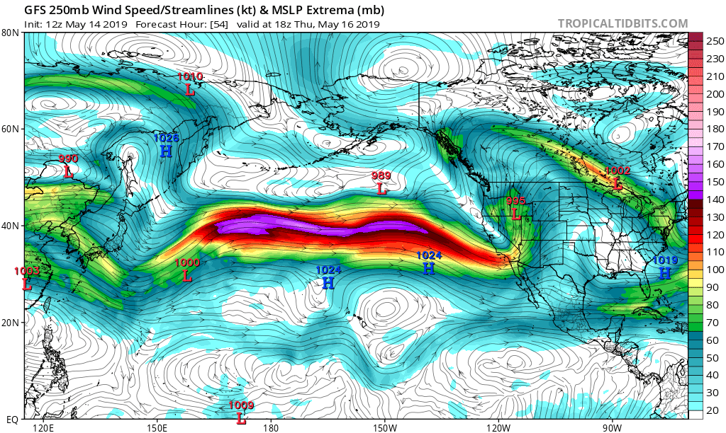
Winter 2018-2019 was a memorable one across much of the continental U.S., with repeated Arctic outbreaks occurring with unusual frequency and intensity across much of the mid-latitude Northern Hemisphere. It’s pretty clear that at least a partial cause of this wild winter pattern was the temporary disruption of the usually-robust circumpolar vortex–the breakdown of which allows pockets of extremely cold Arctic air to spill southward over the continents and subsequently produces some crazy weather conditions due to the ensuing low-latitude thermal contrasts. In such cases, the Arctic itself tends to experience dramatic warming as its “cold air reservoir” is depleted. This winter was no exception. And interestingly, a similar process appears to be evolving at the moment: extremely warm air temperatures and record/near-record low sea ice extent are occurring, with an unusually wavy (wavenumber 6) atmospheric pressure pattern across the Northern Hemisphere. As was the case this past winter, California once again appears to be the beneficiary of an unusually active North Pacific jet stream (especially for the time of year).
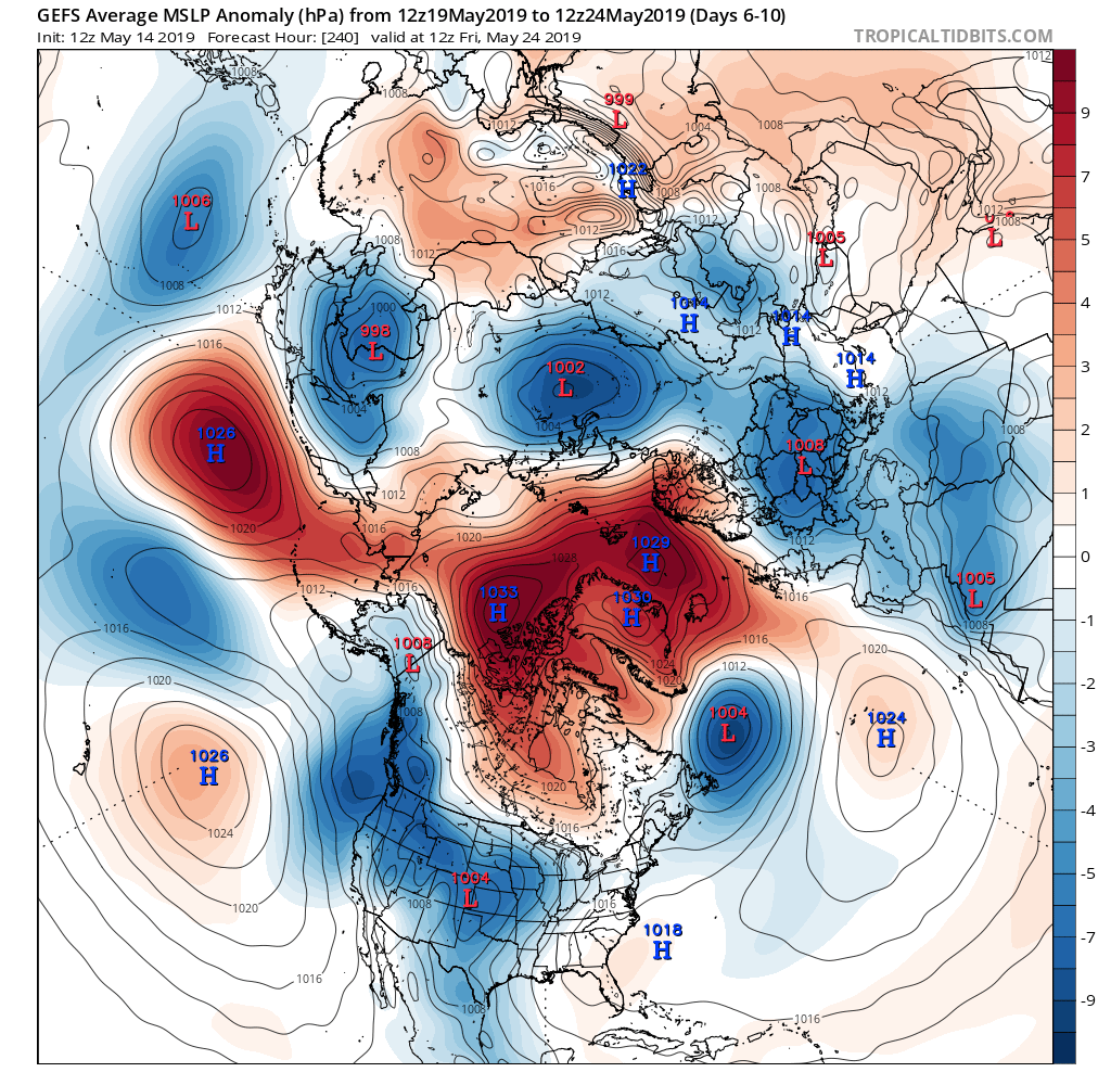
(A modest, but growing, body of recent scientific evidence (including this fascinating new study, out this week) suggests that such polar vortex disruptions have not only been occurring more frequently in recent years, but that rapidly declining Arctic sea ice may be playing a role. This remains a very active–and somewhat contentious–area of research).
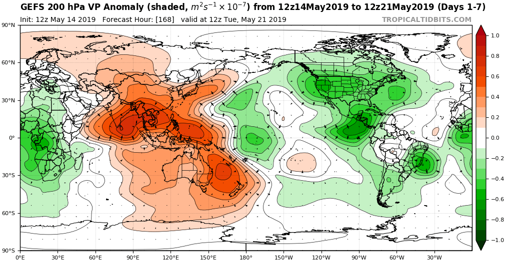
It’s also worth noting that the Madden-Julian Oscillation has been very active for the time of year, and this too is likely contributing to the dramatic and unseasonable re-restrengthening of the east Asian jet (which extends across the Pacific toward California). As the MJO signal slowly propagates, it will eventually move into a position unfavorable for the continuation of active weather across California. Right now, the models are hinting this could happen during the last week in May–likely setting the stage for rapid drying (and perhaps also a pretty sudden warm-up to summer-like heat). But for now: enjoy the upcoming 10 days of “Mayuary.”
Discover more from Weather West
Subscribe to get the latest posts sent to your email.