Record summer heat (in many spots, except SF) fades
After a truly searing start to summer across most of California, especially in the south, the last several weeks have felt rather mild by comparison. The record-breaking heatwaves of July, followed by record warm ocean temperatures later in the summer in SoCal, made for very uncomfortable conditions across some of California’s most densely populated regions for much of the summer. Meanwhile, in interior NorCal, record daytime highs were few and far between–but relentless overnight warmth and persistently above-average daytime temperatures again combined to produce record or near-record summer temperatures. Indeed: across many parts of southern and interior California, 2018 was the warmest summer on record.
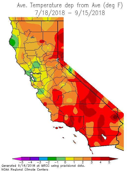
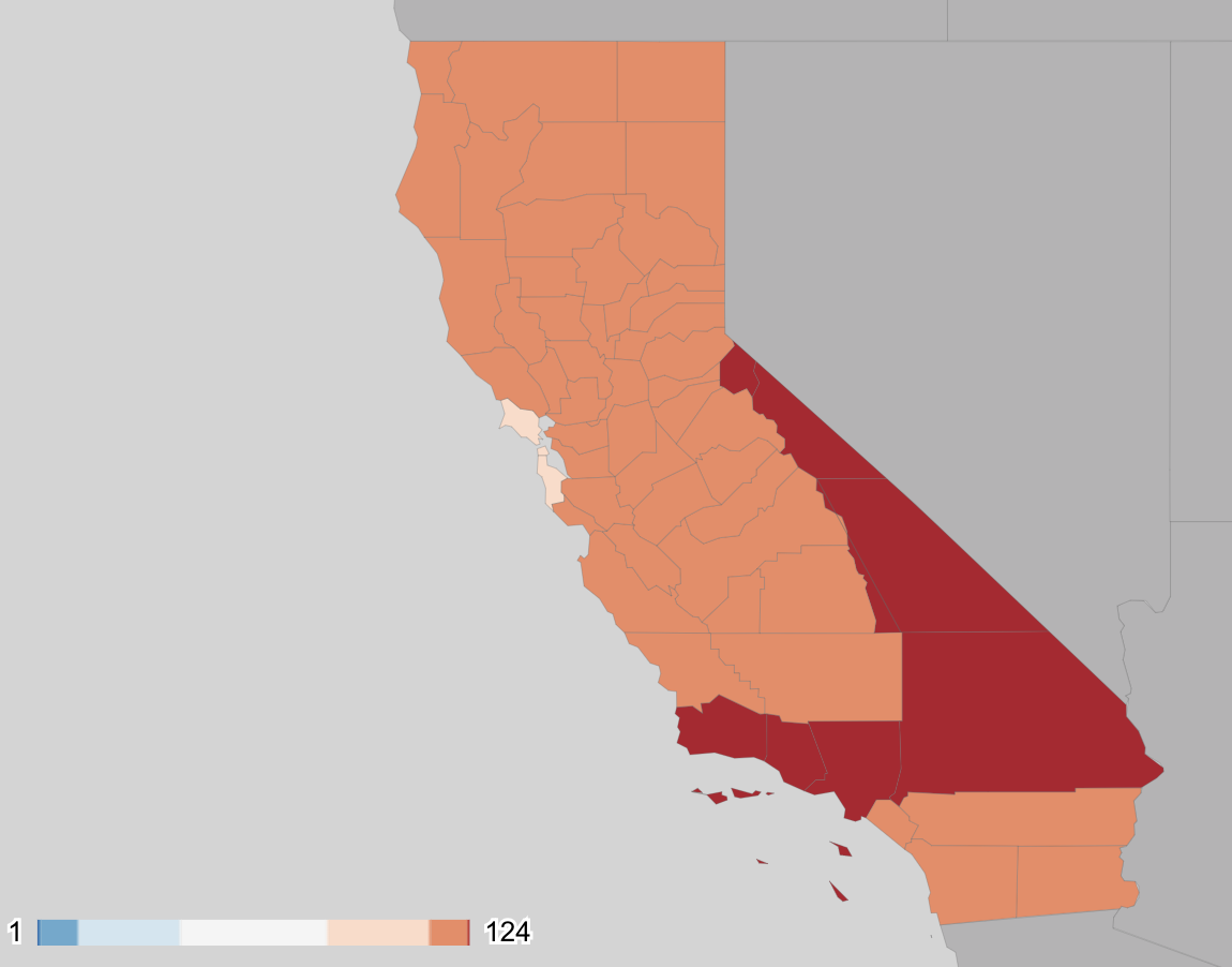
As many folks have remarked over the past couple of months, a striking exception to this relentless California warmth has been the immediate coastline of NorCal from about the SF Bay Area northward, including some of the bayside communities a bit further inland. Those relative few blessed enough to miss out on this summer’s record heat can thank a localized patch of unusually cool ocean water west of San Francisco due to enhanced “upwelling” of deep ocean water this summer. That patch of cool water (which stood in extraordinary contrast to the record-warm 75-80+ degree ocean off of the Los Angeles and San Diego County coastlines) cranked up Nature’s air conditioning in the form of a very persistent Bay Area marine layer, which kept conditions relatively cool and cloudy for most of the summer. It’s important to keep San Francisco’s recent relative coolness in perspective, though–the coastal Bay Area actually experienced average temperatures that were pretty close to long-term averages this summer (daytime highs were slightly cooler than average; nighttime temperatures slightly above). But they certainly *felt* cool relative to the record-breaking warmth of recent summers (it was just over a year ago, for example, that downtown San Francisco hit its all-time record high temperature of 106 degrees).
Wildfire activity moderates (for now), but autumn resurgence plausible
Following an extraordinarily bad start to the fire 2018 fire season, which included the devastating Carr Fire (and incredible “fire tornado” in Redding) and the now-largest wildfire in California history (the Ranch Fire, which exceeded the previous acreage record set by the Thomas Fire just last December), fire activity has moderated somewhat in recent days as temperatures have cooled. Fire risk is still extremely high in many areas, and the traditional peak of fire season in California (which coincides with the often warm and dry autumn offshore winds) has only just begun. At the moment, there are no severe wind events on the horizon, which is good news–but Santa Ana wind season extends through December (as last year’s late-season firestorms vividly illustrated). So after the present reprieve, I would not be surprised to see a renewed surge in heat, wind, and fire activity before the winter rains arrive. I’ll keep my fingers crossed that we get a break this year, though. It’s already been a rough few years as far as California wildfires go.
(As of this writing, there are actually some fire weather watches in effect for the higher elevations surrounding the northern Sacramento Valley due to warm temperatures, low humidity, and gusty winds. While this is not expected to be an especially extreme event, it’s still worth noting given the number of large (but mostly-contained) fires still burning in NorCal and the near record-dry state of vegetation in this region).
Thoughts on recent El Niño research, and context of upcoming 2019 event
The tropical Pacific Ocean is most likely headed for El Niño conditions this autumn and winter, though at the moment sea surface temperatures in this region remain relatively unremarkable. As often happens when an El Niño or La Niña event is in the forecast, there has been a surge in news headlines making proclamations regarding implications for various regions–especially California’s likelihood of seeing a wet (or dry) winter. But are these headlines justified by the science?
In California, there’s quite a bit of folklore surrounding El Niño–even in the water resources and weather communities, where opinions vary widely. For some folks, El Niño means lots of rain; La Niña means drought. For others, the importance of El Niño/La Niña (ENSO) oscillations are seen as largely unimportant, or highly unreliable. Over the past decades, there has been quite a bit of new scientific inquiry that has considerably enhanced our understanding of the connection between ENSO and California precipitation. But most of that scholarly research hasn’t yet permeated popular culture. So, what have scientists learned in recent years?
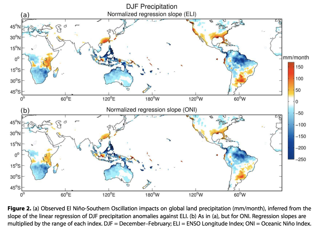
Well, in short: just about everyone is partially justified in their beliefs. ENSO, as a generic predictor of California winter precipitation, is pretty unreliable–the typical correlation between East Pacific ocean temperatures and rainfall here is weak. Interestingly, the connection between ENSO and Gulf of Alaska conditions is quite strong–El Niño yields a persistent deepening of GoA low pressure, and La Niña tends to lead to high pressure ridging in the mid-Pacific. But what happens in California is much more dependent upon what happens immediately off our coastline, less than 1000 miles “upstream.” And recent research demonstrates that the ENSO teleconnection is typically weak in this specific region, despite its considerable strength elsewhere across the North Pacific. That means that influences other than ENSO often dominate the outcome–overwhelming the ENSO signal in terms of how much precipitation California sees during winter.
HOWEVER…it would be incorrect to assume that ENSO is always unimportant. Climate scientists have known for a long time that ENSO involves highly “non-linear” processes in the atmosphere and ocean system. One consequence of this is that especially strong El Niño events are qualitatively different than weaker ones, and actually exert a very strong (and, in the long run, quite reliable) influence on California winter precipitation. In practical terms, this means that we can largely discount ENSO as a useful predictor in California unless there’s a very strong El Niño or La Niña event in place. But if we do make it into that relatively rare territory, watch out! In practical terms, this means that we should probably give little weight to weak to moderate El Niño events–but rather heavy weight to 82/83 or 97/98-level events.
But, you may ask, what about the 2015-2016 event–which was a very strong El Niño from an oceanic perspective but failed to bring heavy California precipitation? Fascinating new research offers a nuanced interpretation of the failure of this event to bring anticipated drought-breaking rains to California. While the “sample size” of very strong ENSO events is small in the real world (essentially 3, counting 15/16), scientists who study ENSO using numerical computer models (similar to those used in day-to-day weather prediction) can generate a much larger number of simulated ENSO events–allowing for more robust conclusions than we can glean from our limited real-world observations alone.
These simulations tell us two important things. First: even the strongest events can occasionally fail to bring expected atmospheric “teleconnections” and subsequent California precipitation simply due to random chance–despite the fact that the vast majority do so in the long run (over many decades). Second: not all strong El Niño events are alike. The spatial distribution of warm tropical ocean temperatures matters quite a bit: “east-focused” SST anomalies are far more likely to generate the expected California precipitation connection as opposed to SST anomalies based in the Central Pacific (which can even favor drought conditions in California)! Recent work has refined the concept of “El Niño Modoki,” which has been floating around for the past decade or so, linking the region of maximum SST to development of anomalous tropical thunderstorms (convection) that generate large-scale atmospheric (Rossby) waves. The position from which these waves emanate, which ultimately determines the location of ridges and troughs in the Pacific jet stream–ultimately make all the difference for California.
And while there is still considerable uncertainty regarding the future of ENSO in a warming world, recent work continues to suggest that we should expect to see increasingly frequent “extreme” ENSO events. Interestingly, this appears to be at the expense of ENSO-neutral years–meaning that we may see an increase in both strong east-based El Niño events (which strongly favor very wet conditions in California) and strong central-based El Niño events as well as strong La Niña events (which are both conducive to dry conditions in California). There is speculation that the enhanced magnitude of these ENSO oscillations might largely explain the increased “precipitation whiplash” we reported in research published earlier this year. But stay tuned for more work on that front in the coming months and years!
Summing it up: what does all this mean for California?
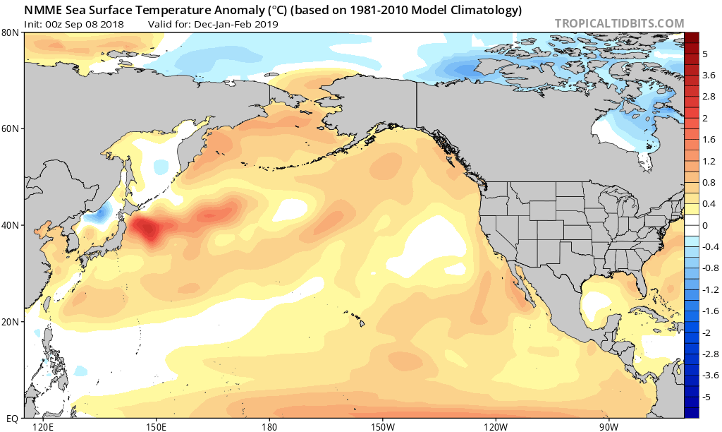
In short: ENSO certainly isn’t everything when it comes to California precipitation, but on the other hand particularly strong El Niño and La Niña events are quite likely to be consequential. Current seasonal projections for 2019 suggest a high likelihood of a weak to moderate El Niño event. In keeping with the above discussion, that unfortunately doesn’t offer much information regarding whether California is likely to experience a wet or dry winter (and this is largely reflected in seasonal precipitation forecasts, which are essentially suggesting equal odds of a wet or dry winter). It is worth noting that relatively warm conditions are quite likely to occur this winter throughout much of the American West; the global models appear to be in pretty good agreement on this front. These days, though, that’s not an especially surprising forecast: the world is a warmer place than it was when today’s “climate normals” were defined, and the odds are increasingly favoring warmer winters as the years go by.
Discover more from Weather West
Subscribe to get the latest posts sent to your email.