What happened to the “Arctic Outbreak” mentioned in the last post?
Well, it happened…somewhat further north than expected. The Pacific Northwest has been shivering through another unusually extended wave of subfreezing temperatures and snow–even along the immediate coast. These very cold temperatures did in fact make it to far northern California, where snowflakes were indeed observed near sea level along the North Coast (Crescent City briefly reported “thundersnow” on January 2nd) and in the lower hills of Mendocino County and the northern Sacramento foothills.
Pretty spectacular high pressure "block" over Alaska causing very complex (& hard to forecast) active pattern across West.#CAwx #ORwx #WAwx pic.twitter.com/nsEXfYijz2
— Dr. Daniel Swain (@Weather_West) January 2, 2017
However, this extremely cold airmass did not make much southward progress beyond the northern third of California. Ultimately, the numerical weather models actually handled the complex atmospheric pattern over the North Pacific very well–pegging the approximate position of the very strong Alaska blocking ridge many days in advance. Subtle differences in the west-to-east flow across the far northeastern Pacific, however, have kept California warmer and wetter than initially expected over the past week. And remember those potential “big storms” I mentioned at the end of the last post? Well, those are now materializing in a pretty eyebrow-raising manner.
Meanwhile, at higher elevations in NorCal, one of the largest sustained snowfalls in several years is currently underway. Much of the Sierra Nevada above about 6000 feet in elevation is in the process of being buried by many inches of snow–and heavy snow rates will likely continue periodically for the next several days. By late Thursday, many places will likely be reporting totals in feet rather than inches. Due to the cold airmass still in place across NorCal, some spots as low as 2500 feet will experience unusually large accumulations before warmer air moves in. These recent, large snow accumulations have already led to a high risk of avalanches in steeper terrain–and may add to the already considerable flood risk developing for the coming weekend.
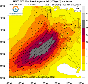
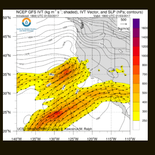
One-two (three?) atmospheric river punch will deliver copious precipitation
A series of extremely moist Pacific storm systems will take aim at California this week. The first of these is already bringing increasingly heavy rain (and mountain snow) along with gusty winds to much of northern California. This initial system probably won’t cause too many problems outside of some notable travel headaches over mountain passes and perhaps some minor local flooding. But this first round of precipitation will set the stage for bigger problems later this week into next week by saturating the soils north of about Santa Barbara and by depositing multiple feet of fresh snow to the Sierra Nevada, even at more moderate elevations.

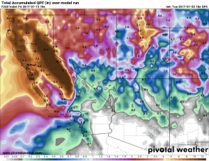
The second storm is (by far) the one of greatest concern, as it will take the form a moisture-laden and slow-moving atmospheric river. While the details with this second system are still somewhat uncertain, virtually all numerical forecast models are painting a very broad area of extremely high precipitation totals over the next 6-7 days across the entire Sierra Nevada mountain chain and also in the coastal mountains from the Oregon border south to Monterey County. It’s still too early to say exactly how much precipitation will fall, but the potential is there for some very impressive numbers–perhaps greater than 20-25 inches along favored western slope regions of the Sierra Nevada and greater than 15 inches in the coastal mountains. Even in low elevation urban areas near the Bay Area and Sacramento regions, 7-day totals exceeding 5-7 inches are entirely possible.
Since this system is expected to be slow moving, the associated atmospheric river may stall over some portion of northern or central California on Sunday or Monday–or even waver back northward temporarily. If and when this occurs (as has been suggested by recent runs of both the ECMWF and GFS), there may be a 100-200 mile wide band of even higher precipitation totals. It’s impossible to say at this time where any stalling or frontal waves might occur, but that has the potential to be a serious situation locally.
This system will also be drastically warmer than its predecessor, and while snow levels could actually start out unusually low (locally in the 2,000-2,500 foot range), they will skyrocket as very strong warm advection occurs Saturday into Sunday. It’s possible that the models are currently presently overestimating the amount of airmass warming that will occur over the weekend, but given the subtropical origins of this atmospheric river snow levels could rise above 9,000 or perhaps even 10,000 feet at the height of the event. This is above essentially all Sierra Nevada passes, and more importantly well above the majority of the recently-fallen snowpack in the 3000-8000 foot range. In fact, 850mb temperatures could rise to around +10C at this time–would would be very bad news indeed for the snowpack. The highest elevations of the Sierra Nevada could see tremendous snowfall totals, likely over 100 inches. And it’s true that storm #1 will drop quite a lot of snow at much lower elevations over the next 24 hours. But much of this snowpack could be erased by 24 hours of warm rain later this weekend.
In addition to big precip totals, 2nd #atmosphericriver event will be very warm, bringing additional threat of snowmelt #flooding. #CAwx pic.twitter.com/KxmSSOtRJg
— Dr. Daniel Swain (@Weather_West) January 4, 2017
Risk of significant, perhaps serious, flooding in parts of California next 10 days

Should the #2 storm this weekend come to fruition as currently depicted by the models, there will be a high risk of fairly widespread flooding throughout smaller rivers and streams in the Sierra Nevada–including the western foothills–and also in the Coast Ranges (especially near the Bay Area). Given the duration and magnitude of the event, there will also be an increasing risk of mainstem river flooding by Sunday. This risk will be amplified by the potential for widespread melting of a rather substantial lower elevation snowpack, especially on Sunday. It’s still too early to say just how serious this likely flooding may become, as this will likely depend strongly on just how persistent the atmospheric river ultimately is on Sunday and how much snowmelt actually occurs. But it does appear that the potential is there for a potentially serious, high-impact flood event across some portion of central or northern California by this weekend, and a more general risk of flooding elsewhere throughout the northern 2/3 of the state.

For better or for worse, this does not really appear to be a Southern California storm event (though that could still change if there is a modest southward shift in the atmospheric river trajectory). It’ll still be wet in Los Angeles and San Diego, and precipitation could become briefly heavy at some point (probably early on Monday). But earlier forecasts suggesting the potential for very large rainfall totals near the LA Basin are no longer looking likely, as the bulk of this moisture is aimed much further north.
Beyond this weekend: conditions will likely remain quite active across the Pacific, and the very long range forecast even hints at the potential for another (though weaker) atmospheric river by the middle of next week. An ongoing active and wet pattern would prolong the risk of flooding throughout California, so this will bear close watching in the days to come.
I’ll be following this event in real-time on Twitter, and I may have another blog post on the Sunday storm if the higher-end flood scenarios are starting to look more likely.
Discover more from Weather West
Subscribe to get the latest posts sent to your email.